Weather
RI Weather: Rain, Heavy At Times, Expected Through Wednesday Night
A couple of low pressure systems will bring anywhere between 2 and 3 inches of rainfall by Thursday morning. Sunshine returns by Friday.

Weather Forecast & Discussion for Rhode Island on November 30, 2016
“The First Forty-Eight”
- Wednesday: Mostly cloudy through the morning, with showers/rain returning by noon. ENE winds 9-13 mph, highs in the middle 50’s. Rain ends early Thursday morning, with lows in the upper 40’s.
- Thursday: Cloudy skies in the morning, with partial sunshine through the afternoon. Winds WNW at 11-14 mph, highs in the middle 50’s. Partly cloudy skies during the night, with lows in the middle 30’s.
Forecast Discussion:
Find out what's happening in East Providencefor free with the latest updates from Patch.
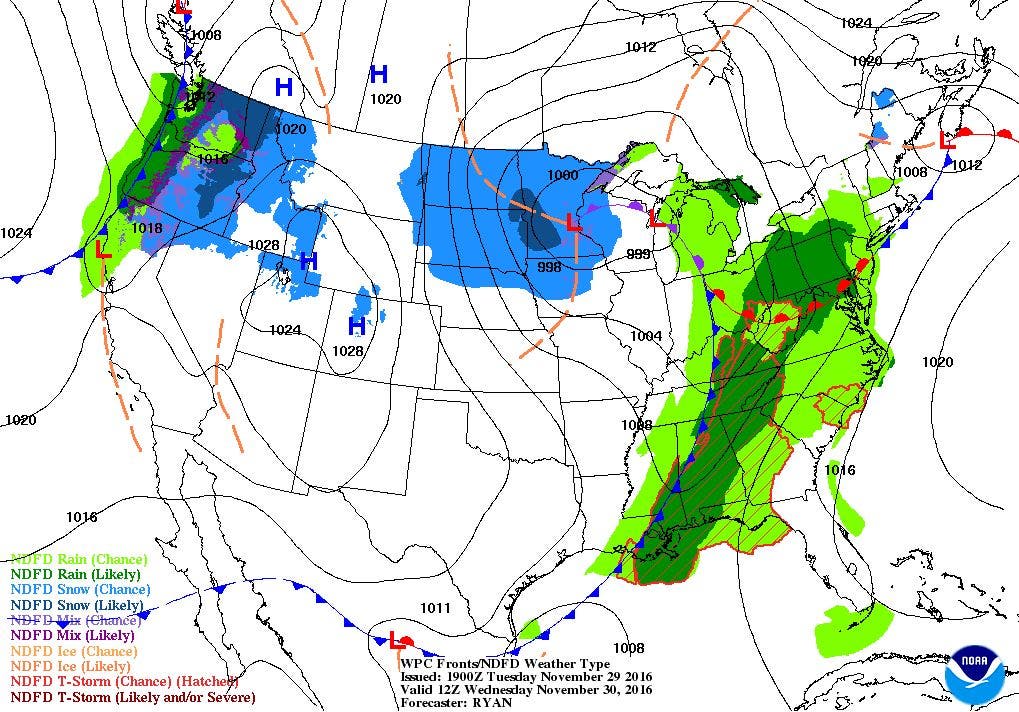
Despite a low pressure system centered over northern Minnesota, this low is actually help create the wet weather we are experiencing at the moment over the Ocean State. A warm front has already moved over eastern Massachusetts, helping to raise our temperatures into the lower 50’s. Also, moderate rain is moving over the region, as we have already received 0.31 inches of rainfall in the last 5 hours at T.F. Green Airport.
We will have some drier air over us through Wednesday morning, before a new low moving into Ohio brings another round of rainfall by noon. Expect heavier rainfall during the afternoon and evening commute. Patchy fog may return for the mid-afternoon. High temperatures will reach the middle 50’s. The “triple point” of an occuluded front, warm front, and cold front will move over the state by 2 a.m. Thursday morning. Rain will persist until then, before tapering off to showers into sunrise. Look for low temperatures Wednesday night to stay in the upper 40’s. Patchy fog will return, so take precaution if driving. Also, please watch for some street and urban flooding, especially if leaves are blocking drainage areas. We could see anywhere between 2 and isolated areas of 3 inches of rain before the two systems are over.
Find out what's happening in East Providencefor free with the latest updates from Patch.
A leftover shower or drizzle is possible Thursday morning, before drier air moves in from the southwest. We may see some partial sunshine before sunset. It will remain warm despite the cold front already passing through us, with the mercury reaching the middle 50’s. Temperatures will begin to fall as we have partly cloudy skies Thursday night. Lows are expected to reach the middle to upper 30’s. High pressure ridging will stay over parts of Rhode Island on Friday, giving us partly to mostly sunny skies. However, we will return to our normal temperatures, as highs are only expected to reach the upper 40’s. Skies remain partly cloudy Friday night, with lows in the middle 30’s.
We begin the weekend with sunny skies on Saturday, as high pressure over Missouri moves eastward. Expect highs to only reach the middle 40’s. It will become cold Saturday night, with clear skies and light winds. Temperatures will fall below freezing, into the upper 20’s north and west of Providence, to near freezing south of Providence. As we go into Sunday, the computer models begin to digress from each other, making for an interesting event. The models agree on the daytime hours, as high pressure will give us sunny skies. High temperatures will only reach the middle 40’s. The models then begin to disagree on Sunday night and Monday’s forecast.
The real problem involves a low pressure system forming in the Southwest U.S. This low will basically track eastward, and stay well south of New England. However, the disagreement involves whether the low tracks further north, and moves the high pressure system giving us dry weather through the weekend. At this time, the American and European models agree the high will keep the low suppressed. So, we will not see any precipitation moving northward towards Southern New England. But, the United Kingdom and Canadian models do believe the low will not only strengthen, but move into the Tennessee River Valley by Sunday night. This means we would see some precipitation Sunday night, and it would be in the form of some snow showers. Then, it would change from snow to rain on Monday morning.
At this time, I feel the low is forming well south of us, and I am not sure how the upper level dynamics seen in the models gets the precipitation this far north. For now, I will call for partly to mostly cloudy skies Sunday night, with the chance for showers Monday. However, my confidence level during this time period is quite low, due to the differing opinions of the models. Expect lows Sunday night in the lower 30’s, with highs Monday in the middle 40’s. We keep sunshine for next Tuesday, with highs reaching the lower 40’s.
Jim Laurie is a local meteorologist who earned a B.S. in Meteorology at Lyndon State College in Lyndonville, VT. Jim has fifteen years of professional experience, with eight years in the field of marine meteorology.


