Weather
Rain, thunderstorms possible tonight through Monday night; sunshine returns Wednesday; cooler temperatures for weekend
It will be quite humid over the next 48 hours, with the threat of showers and thunderstorms into Tuesday morning. The sun returns Wednesday.

Weather Forecast Discussion for Rhode Island on September 19, 2016
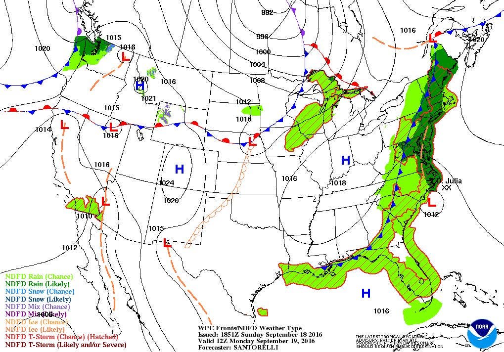
A cold front passing into the western Mid-Atlantic at the moment brought increasing clouds to the Ocean State, especially during Sunday afternoon. Also, thanks to south winds, our dewpoints are in the upper 60’s, making for some humid conditions. We will see patchy fog during the overnight, along with the chance for some showers and thunderstorms. Look for lows to only fall into the upper 60’s. The cold front, becoming quasi-stationary will continue to give us scattered showers and thunderstorms for Monday. We may still see patches of patchy fog right into the mid-afternoon. Without any sunshine, high temperatures will only reach the upper 70’s. By Monday night, the remnants of Julia will try to be absorbed by the stationary frontal boundary. The cold front will slowly move offshore through the overnight, so we will see any showers or thunderstorms dissipate into the morning. We will continue to see patches of patchy fog, with lows in the upper 60’s.
Despite weak high pressure ridging slowly building over us from the west, the front may still linger offshore Tuesday morning. So, despite partly sunny skies, there still may be a widely isolated shower or thunderstorm until noon. High temperatures are forecast to reach the lower 80’s. We will see partly cloudy skies by Tuesday night, as the high pressure ridge fully influences our region. With dewpoints still in the lower 60’s, there is still the chance for some patchy fog. Look for lows to fall into the middle 60’s. Sunny skies return for Wednesday, with highs in the lower 80’s. We will see clear skies Wednesday night, along with light winds. The high pressure center will sit right over Rhode Island at this time, helping to create radiational cooling. Low temperatures will fall into the upper 50’s.
After Thursday, a strong high pressure ridge coming off the Atlantic, along with a high pressure system over central Canada will provide us with dry air right into the weekend. So, the weather looks sunny as we officially start autumn at 10:21 a.m. Thursday morning. Look for highs in the upper 70’s to near 80 into Friday, with lows near 60 Thursday and Friday night. By the weekend, however, cooler air from Canada will move down into New England. We will see partly to mostly sunny skies for the weekend, but highs will only reach the upper 60’s to lower 70’s, with lows in the middle 50’s.
Tropical Update: In the Atlantic, we have two named systems. Tropical Depression Julia is still giving rainfall to North Carolina. As of 5 p.m. Sunday, Julia was centered about 110 miles south-southeast of Myrtle Beach, SC with sustained winds of 30 mph. She is moving north-northwest at 7 mph. The system will move inland within the next 24 hours, and peter out as a remnant low by Wednesday afternoon. It will then dissipate by Thursday. This will not be a threat to Rhode Island.
Meanwhile, Tropical Storm Karl is 1110 miles east of the Leeward Islands as of 5 p.m. Sunday. Maximum sustained winds are at 40 mph, and is moving west-northwest at 15 mph. As the system moves away from any vertical wind shear, he will begin to strengthen. After 72 hours, Karl is forecast to become a hurricane. The system will stay away from Cuba, Puerto Rico, and the Dominican Republic. But, it will send heavy swells down to that area. At this time, Karl is not a threat to the Bahamas or ot Bermuda within the next 5 days.
Finally, an area is being watched by the National Hurricane Center, as it might become the next named tropical system. At this time, it is near the Cabo Verde Islands, moving west-northwest to northwest. There is a 50% chance it will become a tropical system within 48 hours, and a 80% chance within the next 120 hours.
Jim Laurie is a local meteorologist who earned a B.S. in Meteorology at Lyndon State College in Lyndonville, VT. Jim has fifteen years of professional experience, with eight years in the field of marine meteorology.


