Weather
RI Weather Forecast: Updated Wind, Cold Estimates
Temperatures plunge to dangerous levels Thursday night.


We've updates this story with the most recent estimates (Monday afternoon) from the National Weather Service regarding wind chill factors and wind gusts.
• Thursday: Chance for snow showers after 2 a.m. before ending by 8 a.m. Partly sunny, with another chance for scattered snow showers after 2 p.m. Highs will be in the middle 20’s, with breezy NW winds of 15-20 mph and gusts of 30 mph. Scattered snow showers Thursday night, and remaining windy and brutally cold. Lows in the middle to upper single digits, with wind chills between -10 to -20 degrees.
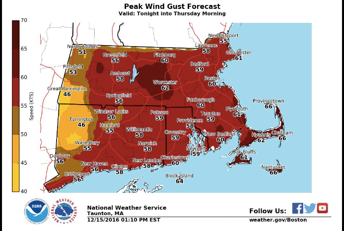
The winds are now expected to get as high as 60 miles per hour.
Find out what's happening in East Providencefor free with the latest updates from Patch.
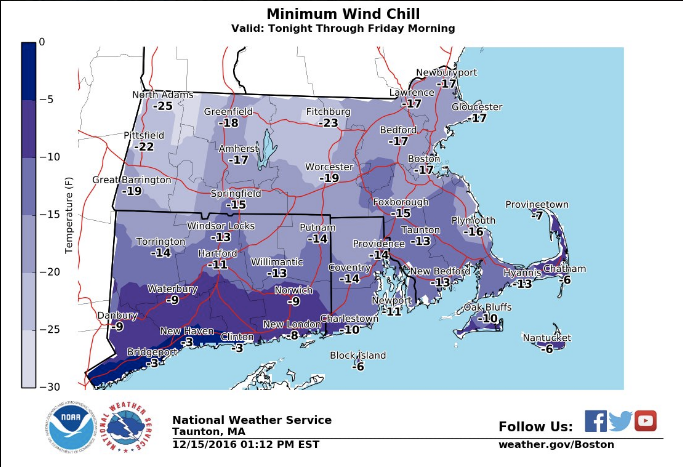
The windchill is expected to drop as low as 14 degrees below zero.
Initial Forecast Discussion:
Winds will be increasing, due to the cold air plunging into Southern New England, as well as a tightening pressure gradient. We may see a little sunshine Thursday afternoon, but lake effect snow may make its way into Rhode Island by Thursday evening. It will also be a horrible time to be outside, as we experience temperatures falling into the single digits. When you add the wind chill, it will feel like 10 to 20 below zero. So, if you absolutely have to be outside early Friday morning, please dress in layers, and protect any exposed skin.
By Friday, a very strong high pressure system moves into the Mid-Atlantic, bringing bright sunshine. But, that sunshine will be ineffective, as high temperatures will struggle to reach 20 degrees. Winds will be diminishing, so it will feel warmer to our skin. This high will quickly move to our east, allowing for a lot of moisture to our west to enter the atmosphere. We will see increasing clouds Friday night. A large low pressure system will bring snow showers to the area by about 5 a.m. Saturday morning. Low temperatures will fall to near 10. However, with winds from the south, temperatures will rise quickly. Snow will slowly mix with some sleet during the late morning, then mix with rain by the early afternoon. Temperatures will be warm enough that the precipitation stays as rain after 4 p.m. Highs will eventually reach the lower 40’s. We stay on the warm side of the system Saturday night and Sunday, so any precipitation we receive will be just rain. Saturday night’s lows will only fall to near 40, with Sunday’s highs reaching the upper 40’s. Rain and showers will taper off by 4 p.m. Sunday afternoon. Skies will slowly clear Sunday night, and temperatures will return to normal, falling into the lower 20’s.
High pressure will move directly over northern New Hampshire by Monday afternoon, giving us mostly sunny skies. High temperatures will be colder than Sunday, when we only reach the lower 30’s. We will see partly cloudy skies Monday night, with lows near 20. By next Tuesday, the high will try to protect us from moisture coming up from the south. A low pressure system may bring some rain and snow after the evening commute. At the moment, the models believe the low will stay far enough south from us. Look for highs next Tuesday in the middle 30’s.
Find out what's happening in East Providencefor free with the latest updates from Patch.
Jim Laurie is a local meteorologist who earned a B.S. in Meteorology at Lyndon State College in Lyndonville, VT. Jim has fifteen years of professional experience, with eight years in the field of marine meteorology.


