Weather
RI Weather: Low Snow Accumulations Thursday; Snow Showers New Year's Eve
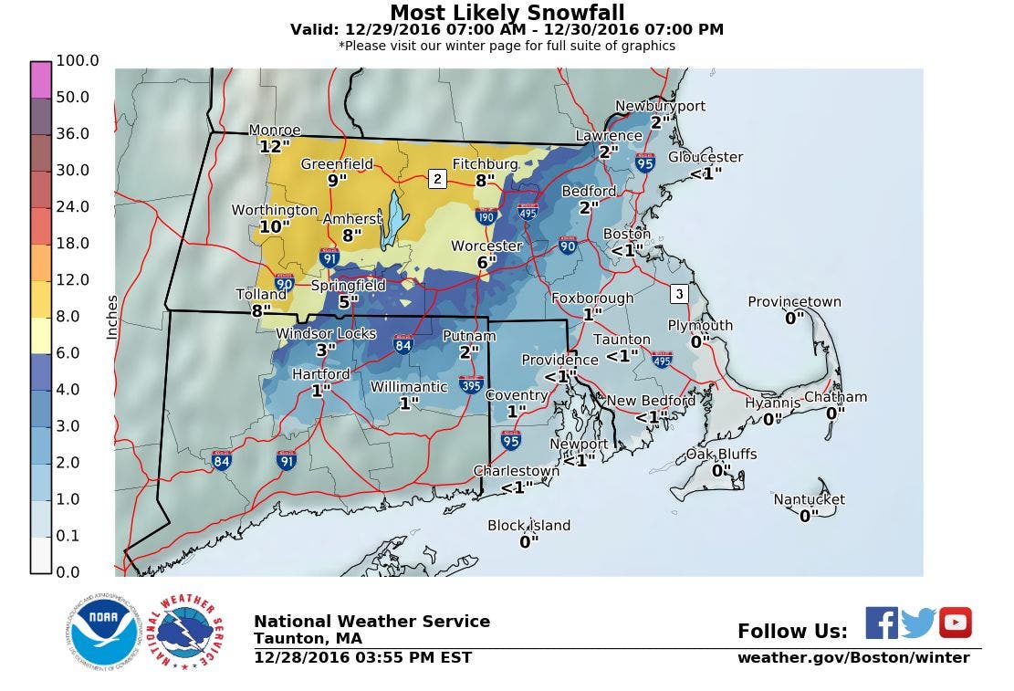
While most of New England sees good snowfall, Rhode Island remains on the warm side. But, a few snow showers may fall at midnight Saturday.


Weather Forecast & Discussion for Rhode Island on December 29, 2016
“The First Forty-Eight”
- Thursday: Overcast with snow showers by mid-morning. Precipitation changes to rain, heavy at times, during the afternoon. Will remain snow north and west of I-295 into the early afternoon. Expect a coating to an inch from Warwick to Woonsocket, and 1-3 inches for extreme northwest RI. Patchy fog is expected during the mid and late afternoon south of Warwick. Highs will be in the lower to middle 40’s, with SE winds of 13-17 mph. Rain will taper off by 10 p.m., with a chance for rain to change back to snow after 1 a.m. Snow showers may continue until 3 a.m. Lows in the upper 20’s, with strong winds.
- Friday: Mostly sunny and windy. Winds will come from the WSW at 20-25 mph, with gusts of 40 mph. Highs will be in the upper 30’s. Partly to mostly cloudy skies Friday night, with diminishing winds. Lows will be in the lower to middle 20’s.
Forecast Discussion:
Find out what's happening in East Providencefor free with the latest updates from Patch.
At the moment, we are awaiting a cold front that will move towards the east coast later on Thursday. We will see partly to mostly cloudy skies Wednesday night, with increasing clouds after midnight. The high pressure ridge moves offshore Thursday morning, allowing a developing area of low pressure into southern Pennsylvania by 11 a.m. We may see precipitation start off as snow showers between 9 a.m. and 11 a.m. However, because all the colder air is to our northwest, the precipitation will change over to rain after noon. We may see heavy rainfall, along with dense fog, during the mid and late afternoon hours, as that low develops rapidly over Rhode Island. Expect high temperatures in the lower to middle 40’s. As we head into Thursday night, temperatures will fall below freezing. So, any light rain showers may change back to snow showers, before all the precipitation ends around 3 a.m. Little to no extra accumulations are expected. I see just a coating to an inch from Warwick north to Woonsocket. For anyone in Burrillville and Foster, I am expecting just 1-3 inches. If you want to look at a snowfall map, click here. It will remain windy, with winds of 15-20 mph, and gusts of 30 mph is expected inland. Low temperatures will be in the upper 20’s. The south coast may see gusts as high as 50 mph. A Wind Advisory may be needed for Rhode Island and southeast Massachusetts.
The low will move into Maine, but the pressure gradient between the lows’ center and high pressure ridging to our west will be tight. Tight pressure gradient mean strong winds, and Friday will be no exception. Despite mostly sunny skies, winds will remain strong, coming from the WSW at 20-25 mph, with gusts of 40 mph. Look for high temperatures only in the upper 30’s. We will see partly to mostly cloudy skies Friday night, with diminishing winds. Lows will fall into the lower to middle 20’s. There is extra moisture behind the low still lingering over the Mid-Atlantic; hence, this is why I am forecasting extra cloud cover for Friday night. High pressure centered over the Southeast U.S. will bring a ridge over Southern New England for New Year’s Eve, giving us mostly sunny skies in the morning and highs in the middle 30’s. A quick clipper type system moves out of the Great Lakes by Saturday night, giving us increasing clouds through the afternoon, with some snow showers expected by 8 p.m. So, we will be singing Auld Lang Syne with some light snow possible at midnight, and lows near 30. Accumulations will be light, with a coating to an inch possible. Snow showers will end by 4 a.m.
Find out what's happening in East Providencefor free with the latest updates from Patch.
We begin 2017 on Sunday with mostly sunny skies by 11 a.m. We will see temperatures be slightly warmer, with highs in the lower 40’s. We keep partly cloudy skies until midnight, with some increasing clouds by dawn Sunday night. Lows will be in the upper 20’s. By Monday, the high pressure ridge will break down, as a swath of moisture from the Southeast U.S. will try to move northward. We will have limited sunshine Monday morning, with the risk for rain showers arriving by 11 a.m. Showers will become light to moderate rain by the evening commute. Highs will be in the lower 40’s. A low pressure system in the Delmarva Peninsula and a low developing over the Ohio River Valley Monday night will continue to deluge us with rain, and lows will be in the middle 30’s.
The Delmarva low will continue to give us showers and rain for the daytime hours Tuesday, with highs in the middle to upper 40’s. We will see the precipitation end Tuesday night, but keep overcast skies. Lows will be in the upper 30’s. The low over Ohio then moves eastward, giving us the risk for more rain on Wednesday. At the moment, the European model pushes the Ohio low into Canada, and away from Southern New England. But, the Canadian, United Kingdom, and American models all believe the low will move east, giving us more rain. So, with a majority of models seeing rainfall, I will keep rain in the forecast for Wednesday, with highs in the middle 40’s.
Jim Laurie is a local meteorologist who earned a B.S. in Meteorology at Lyndon State College in Lyndonville, VT. Jim has fifteen years of professional experience, with eight years in the field of marine meteorology.


