Weather
RI Weather: Messy Monday Morning Commute; More Snow Wednesday Night?
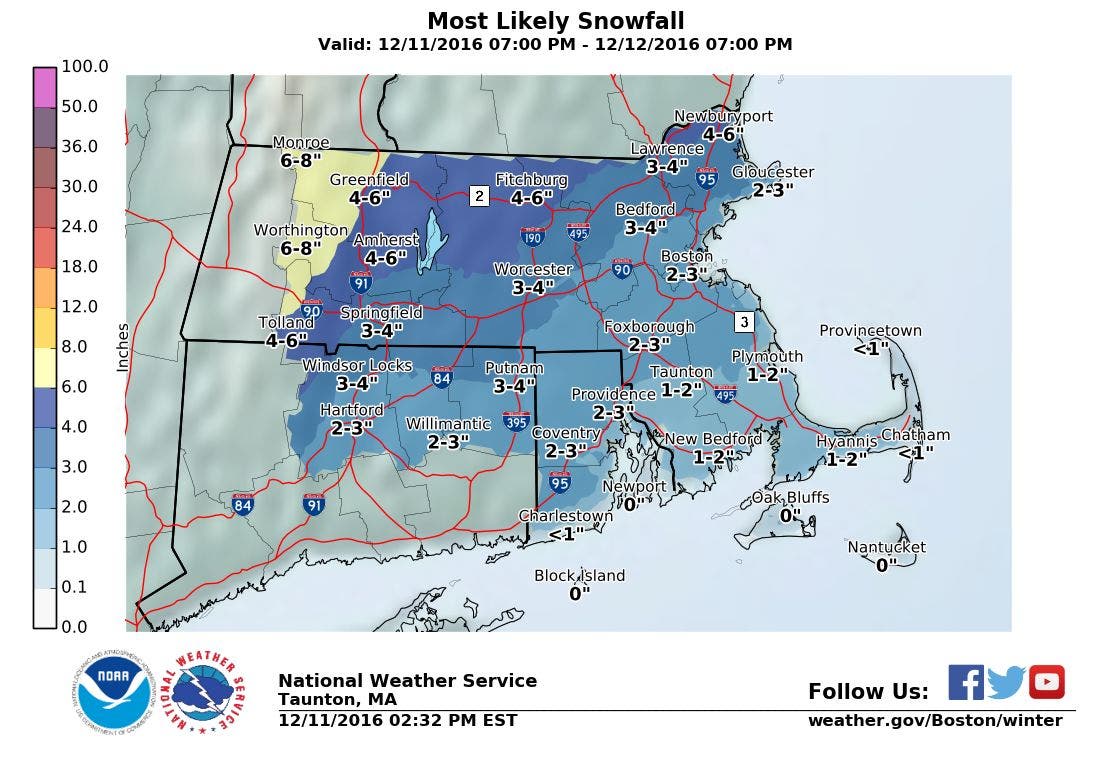
Radar imagery has snow arriving by 6 p.m. Snow continues overnight, a wintry mix for the morning commute, with rain by the afternoon.


Weather Forecast & Discussion for Rhode Island on December 12, 2016
“The First Forty-Eight”
- Monday: Snow until 6 a.m., then becoming freezing rain. Freezing rain slowly shifts over to rain between 6 and 9 a.m. Freezing rain and rain from 9 a.m. to noon, before becoming all rain by noon. Snowfall totals will be 1-3 inches, with heavier amounts north and west of I-295. Rain tapers to showers by 3 p.m. with drizzle ending by 6 p.m. Skies become partly cloudy overnight. Highs will be in the upper 40’s, with lows near 30. Winds WSW 10-13 mph with occasional gusts of 20-25 mph.
- Tuesday: Sunny with highs in the lower 40’s. Winds WSW 8-11 mph. Partly to mostly cloudy Tuesday night, lows in the upper 20’s.
Forecast Discussion:
Find out what's happening in East Providencefor free with the latest updates from Patch.
At the moment, a Winter Weather Advisory is only in effect for northwest Providence County, which will begin at 7 p.m. and last until 1 p.m. Monday. At this time, a low pressure system is centered over eastern Iowa. Snow showers has reached western Connecticut, and one snow band is northeast of Springfield, MA. We should see snow showers reach western Rhode Island between 6 to 7 p.m. Light to moderate snow begins around 11 p.m. moving south to north. Moderate snow is expected north and west of Providence during the overnight. The coastline will changeover first, by about 4 a.m. The warm front will slowly move through Southern New England south to north by the morning commute. However, the colder air at the surface may linger longer than the models are indicating. So, we may see a mix of freezing rain and rain during the late morning hours. Otherwise, freezing rain may be falling during the commute itself. Look for accumulations of 2-3 inches north and west of I-295, with a coating to an inch in the capital city south. As the warm front pushes into Northern New England by the early afternoon, we will see just rain. Highs will reach the upper 40’s. Skies will slowly clear into Monday night, as high pressure takes over. Skies will be partly cloudy with lows in the upper 20’s.
So, please be careful driving during the morning commute Tuesday, as cooler temperatures creates black ice on untreated roads. But, we will have sunny skies, and temperatures will warm into the lower 40’s. We will see mostly cloudy skies Tuesday night, as a weak cold front in northern Quebec passes to our north. The low level moisture will not bring any precipitation, and lows will fall into the middle to upper 20’s. We return to mostly sunny conditions during Wednesday, as a ridge of high pressure stays over New England. Expect highs in the upper 30’s. However, the computer models have been unsure whether a new area of low pressure forms just off the coast of Cape Hatteras, North Carolina. Combined with a low pressure system over Quebec, there is the chance at seeing snow showers by midnight. Because the low strengthens well southeast of us, we would not see much in accumulations. Low temperatures are forecast to be in the middle 20’s.
Find out what's happening in East Providencefor free with the latest updates from Patch.
A second weak disturbance would pass over New England by the mid-afternoon on Thursday. So, we would remain overcast, with the risk for more scattered snow showers by 2 p.m. Also, an Arctic front will be coming through by 7 p.m., helping to bring the coldest air of the season upon us. Highs on Thursday would only reach the upper 20’s, with lows Thursday night reaching the middle single digits.
A few flurries may still be flying during the commute Friday morning; otherwise, increasing sunshine is expected during the day. However, the mercury will barely reach 20 degrees on our thermometers for high temperatures. We will see partly to mostly cloudy skies Friday night, but winds will begin to turn to the southwest. This will help keep our temperatures constant Friday night, with lows only falling into the middle teens. By Saturday morning, a very large area of low pressure will move into Indiana. However, lots of rainfall will be ahead of the center, and we may see snow beginning by 7 a.m. Then, as the day wears on, snow will change over to rain by mid-afternoon, with temperatures climbing into the lower 40’s. The warm front passes north of us by the late afternoon, keeping us under rain for Saturday night. Low temperatures only fall into the upper 30’s.
For next Sunday, we will be one week away from Christmas. However, the precipitation will stay us rain through the morning, before tapering to showers in the late morning. Skies remain mostly cloudy after 2 p.m., after the front moves offshore. Look for highs to reach the middle 40’s, with clear skies and lows in the middle 20’s next Sunday night.
Jim Laurie is a local meteorologist who earned a B.S. in Meteorology at Lyndon State College in Lyndonville, VT. Jim has fifteen years of professional experience, with eight years in the field of marine meteorology.


