Weather
RI Weather: Mild Weather Ends Friday; Dry Holiday Weekend Ahead
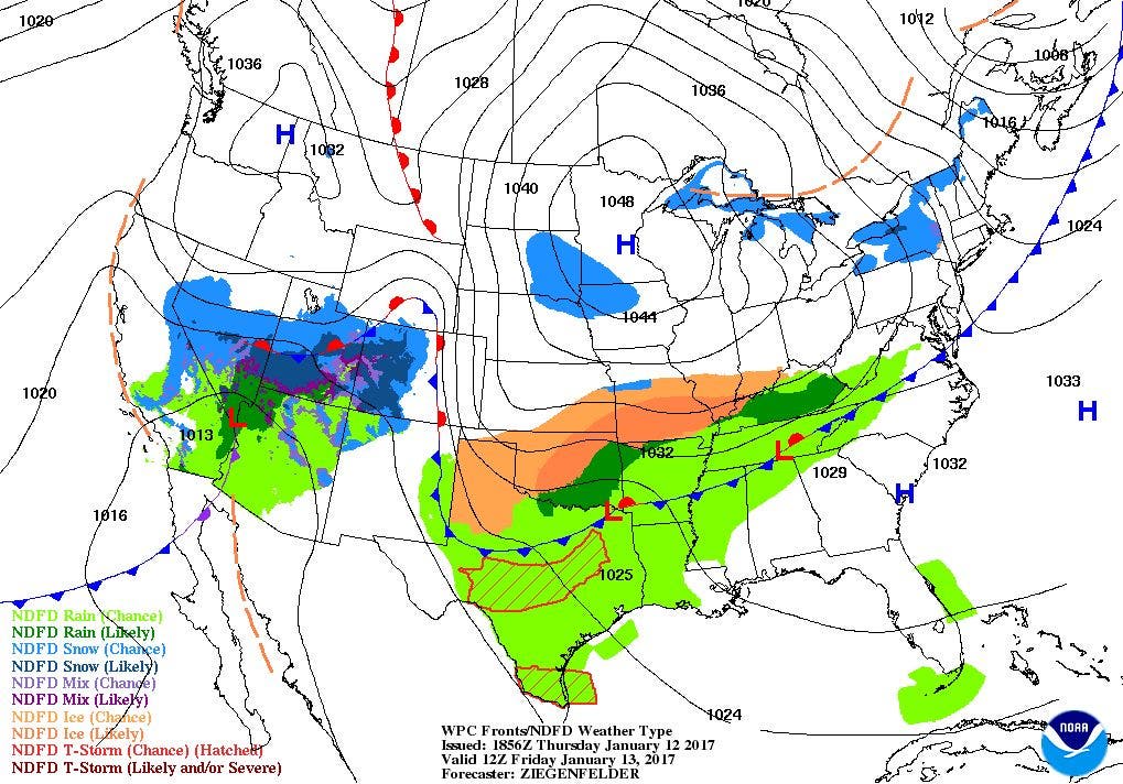
After a cold front brings some showers Thursday night, a high pressure system will control our weather for the holiday weekend.

Weather Forecast & Discussion for Rhode Island on January 13, 2017
“The First Forty-Eight”
- Friday: Sunny and turning colder. High temperatures will be in the middle 40’s before dropping. Winds will come from the NW at 11-14 mph. Clear skies and cold at night, with lows in the upper teens.
- Saturday: Partly sunny skies with highs in the lower 30’s. Winds will come from the SSW at 6-9 mph. Overcast skies during the overnight, with lows in the lower 20’s.
Forecast Discussion:
Find out what's happening in East Providencefor free with the latest updates from Patch.
At the moment, a cold front over the Mid-Atlantic will be moving over the Ocean State during the early to late evening. The overcast skies is due to this front, as moisture ahead of it spills into the area. We will begin to see some showers within the next two hours, but end just after midnight. Skies will begin to clear heading into sunrise. Look for low temperatures tonight to be in the lower 40’s. Sunny skies are expected for Friday, but it will not be as mild as today. In fact, we tied a record high of 59 degrees at T.F. Green Airport, which was set back in 1975. Colder air in front of a high pressure system will begin to infiltrate the state by the afternoon. So, despite high temperatures in the middle 40’s, the mercury will begin to fall during the late afternoon. We return to colder temperatures Friday night, under clear skies. Low temperatures are expected to be in the upper teens.
We enter the holiday weekend still under the influence of the high on Saturday. However, moisture from a frontal system to our south and a weak low over Quebec, Canada will help bring increasing clouds by the afternoon. So, I will call Saturday partly sunny, with highs in the lower 30’s. I would not be shocked if there were a few flurries in the area Saturday night, with a few snow showers along the south coast and Block Island. No precipitation is expected in Foxboro, when the New England Patriots play at 8:15 p.m. We will remain under overcast skies into Sunday morning, with lows in the lower 20’s. High pressure coming out of Quebec will return us to sunny skies by late Sunday morning, with highs in the upper 30’s. We will keep clear skies into Sunday night, with lows in the lower to middle 20’s.
Find out what's happening in East Providencefor free with the latest updates from Patch.
Some of us will have Monday off, as it will be Martin Luther King Jr. Day. We will have sunshine in the morning, with some high and mid-level clouds taking over the skies by the afternoon. Look for highs in the upper 30’s. A low pressure system in the central U.S. will bring a frontal boundary into Southern New England by Monday night. We will begin to see some showers and light rain by 2 a.m. Tuesday morning. Look for lows in the lower 30’s. At this time, I do not believe there is enough cold air for the precipitation to start as snow. Also, temperatures will be rising through the overnight.
We will see isolated showers through Tuesday, and remain overcast Tuesday night. Look for highs in the middle 40’s. By Tuesday night, a cold front will bring the next round of showers and light rain, between 1 and 3 a.m. Wednesday morning. Lows will fall into the middle 30’s. We will continue to see showers and light rain Wednesday, with precipitation ending after 8 p.m. Highs are expected to be in the upper 40’s. We will remain mostly cloudy Wednesday night, with lows in the lower 40’s.
We end the seven day forecast looking at next Thursday’s weather. A low pressure system forming over Mississippi will try to bring the risk for some showers and light rain by the evening hours. However, the computer models disagree on the timing and track of the low. So, I will call for partly sunny skies, with highs in the lower 50’s.
Jim Laurie is a local meteorologist who earned a B.S. in Meteorology at Lyndon State College in Lyndonville, VT. Jim has fifteen years of professional experience, with eight years in the field of marine meteorology.