Weather
RI Weather: Snow Arrives Friday; Another Storm Possible Saturday Night?
Colder air arrives this evening. A developing coastal low will bring snow before the morning commute Friday. A weekend storm is possible.


Weather Forecast & Discussion for Rhode Island on January 5, 2017
“The First Forty-Eight”
- Thursday: Mostly sunny in the morning, with increasing clouds through the afternoon. It will be colder, with highs in the middle 30’s. Winds come from the WSW at 12-15 mph, with occasional gusts of 25 mph. Mostly cloudy at midnight, with lows in the middle 20’s.
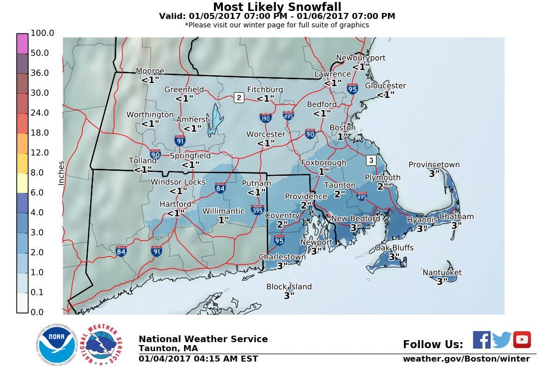
- Friday: Light snow develops by 2 a.m., especially along the south coast. Snow showers remain light through the daytime hours, ending by 4 p.m. A coating to 2 inches possible from Warwick northward; 2-3 inches for the rest of the state. Highs will be in the middle 30’s, with N winds of 6-9 mph. Partly cloudy skies Friday night, with lows in the lower 20’s.
Forecast Discussion:
Find out what's happening in East Providencefor free with the latest updates from Patch.
A cold front is now pushing through the Ocean State, which is helping create the high and mid-level cloud cover staying over parts of Pawtucket and Providence. An isolated shower is even possible, as we await some drier air behind the front. High pressure ridging to our south will eventually clear skies after midnight. Colder air behind the front will rid the atmosphere of the milder temperatures, as lows fall into the middle 20’s. That ridge of high pressure will keep us dry for Thursday, giving us mostly sunny skies. But, high temperatures will struggle to reach the middle 30’s. Also, we will feel a good westerly breeze, with occasional gusts of 25-30 mph, especially in higher elevated areas. As we go into the early afternoon, we will begin to see increasing clouds, as moisture from the southwest moves over Southern New England.
Over the last several days, the computer models have been showing a low developing off the coast of South Carolina by about 3 p.m. Thursday afternoon. Although the low will stay well southeast of Rhode Island, it will help bring moisture up into Southern New England. A small disturbance over eastern Pennsylvania will create the snow showers into our region. At the moment, the models believe we will not see any snowflakes begin to fall until after midnight. The models feel the south coast, the Cape, and the Islands will see the higher amounts, while further inland the amounts lower. Light snow is expected during the morning commute on Friday, so please take precaution and give yourself more time to get to work or the kids to school. As the low in the ocean intensifies, it will move off to the northeast, and stay far enough away from the region to see any high snowfall amounts. At this time, I only see a coating to 2 inches in inland areas up to Warwick, with 2-3 inches possible for the rest of the state. If the storm tracks further south, these amounts will lower; however, if the storm tracks further north, the amounts will increase. So, keep listening to weather updates into Friday morning. High temperatures will be in the middle 30’s. Snow showers end by 4 p.m., as the precipitation shield moves off to the east. Skies become partly cloudy Friday night, with lows in the lower 20’s.
Find out what's happening in East Providencefor free with the latest updates from Patch.
We enter Saturday with a weak high pressure ridge over New England. However, the computer models are predicting another strong low will develop off the coast of Georgia and South Carolina Saturday afternoon. If the ridge is not strong enough, we may see some snow showers or light snow from this system during early Saturday evening. Depending on the location of the low, we may see snow showers or light snow continue into Sunday morning. At the moment, all the models appear to be keeping the system offshore, so we only have a slight chance at seeing snowfall. Saturday’s highs will only be in the upper 20’s, with Saturday’s lows in the upper teens.
By late Sunday morning, all the models agree the low and the precipitation shield will be east of Rhode Island. Skies will begin to clear, and see mostly sunny skies. However, a strong dome of cold air will move over the area, as our high temperatures will struggle to reach the middle 20’s. By Sunday night, we will have clear skies, and it will be very cold, as the mercury falls into the upper single digits. By Monday, despite the sunny skies, high temperatures will only reach the upper teens. By Monday night, a weak low over passing over Canada will bring overcast skies with the risk for some snow showers. Low temperatures will actually fall just a couple of degrees, staying in the upper teens.
Snow showers end by the morning commute, but we will keep overcast skies over Southern New England for the rest of Tuesday. With winds turning to the southwest, it will help bring warmer air back into the region, and raise our temperatures. Expect highs to be back to normal, reaching the middle to upper 30’s. A few rain or snow showers arrive by 3 a.m. early Wednesday morning, before turning to rain showers by late morning. Highs will reach the middle to upper 40’s.
Jim Laurie is a local meteorologist who earned a B.S. in Meteorology at Lyndon State College in Lyndonville, VT. Jim has fifteen years of professional experience, with eight years in the field of marine meteorology.


