Weather
RI Weather: Snow Arrives Sunday Afternoon, Wintry Mix Sunday Night; Next System Wednesday?
Both systems Sunday night and Wednesday will be track dependent. However, we will see just small accumulations right now by Monday morning.

Weather Forecast & Discussion for Rhode Island on December 10, 2016
“The First Forty-Eight”
- Saturday: Sunny and cold. Highs in the lower 30’s, with NW winds of 9-12 mph. Wind chills in the middle 20’s. Clear skies at night with lows in the upper teens to lower 20’s.
- Sunday: Partly sunny through the daytime hours. Highs in the middle 30’s, with westerly winds at 4-7 mph. Snow arriving between 5-7 p.m., with a coating to 2 inches possible. Higher amounts would be north and west of Providence. Lows in the upper 20’s.
Forecast Discussion:
Find out what's happening in East Providencefor free with the latest updates from Patch.
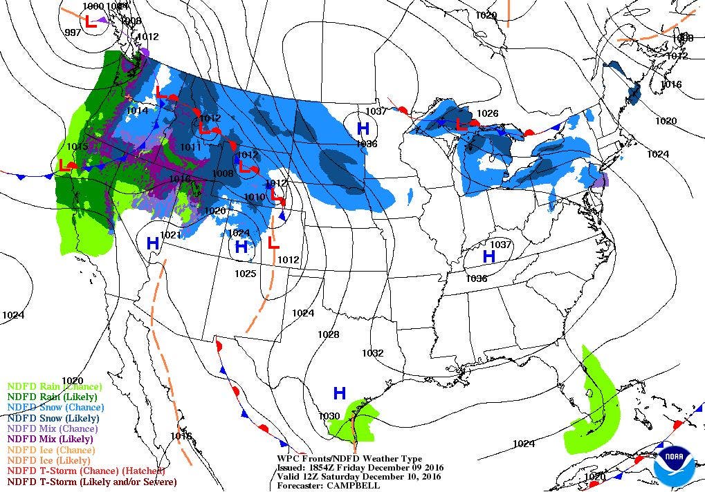
Despite high pressure over southwest Missouri, a pressure gradient remains over Southern New England, thanks to a low centered over Newfoundland, Canada. This is what is creating the pressure gradient, causing the strong northwest winds. Despite highs in the middle 30’s, the wind chill make sit feel like the middle 20’s. This will continue into tomorrow, before the high moves closer to New England.
Winds will decrease tonight, as the low moves northeast, and the high continues to move eastward. The pressure gradient relaxes, causing the winds to diminish. But, with clear skies tonight, and lows falling into the upper teens, wind chills will make it feel like the upper single digits. The high will continue to give us sunshine on Saturday, but it will remain quite cold, with highs barely reaching freezing. We keep clear to partly cloudy skies Saturday night, with lows in the upper teens north of Providence. South of Providence, lows will fall into the lower 20’s.
Find out what's happening in East Providencefor free with the latest updates from Patch.
We will keep some sunshine Sunday morning, before increasing clouds take over the skies Sunday afternoon. Look for highs to reach the middle 30’s. Based on the most current models, it appears the high protects us from any snow showers until midnight. But, this is much different than what the last few model runs have been showing me. So, I feel we did to go in-between the times, and say we will see the first few snowflakes fall between 5 and 7 p.m., with light snow after 9 p.m. I feel the higher accumulations will be north and west of Providence, as they stay with enough cold air to keep it as snow. The coastal region may change over to a wintry mix by sunrise. So, this will make for a treacherous commute Monday morning. Lows will be in the upper 20’s, before slowly rising as we approach dawn.
The warm front associated with this system will move south to north, and be over Rhode Island by the start of the morning commute. We will still see snow during the commute, with a change to a rain/snow mix for the rest of the morning. Then, the state will see a changeover to plain rain for the afternoon. I feel the northern part of the state could see up to 2 inches, with lower amounts the further south. Temperatures will warm into the upper 30’s. Now, this forecast is very track dependent, and the models are showing a secondary low forms to our west. This helps us stay in the warmer zone. But, if it forms east, colder air stays over us, meaning we could remain as all snow. My best advice would be to continue listening for weather updates. I should have a new update during Sunday afternoon, before the storm arrives.
Skies will clear Monday night, with temperatures slowly falling into the upper 20’s. We we will see sunny skies return on Tuesday, with highs in the upper 30’s. High pressure stays south of us, giving us partly cloudy skies Tuesday night, with lows in the middle 20’s. This may help create black ice, as any snowmelt during the day will freeze once again.
As we move into Wednesday, the computer models once again disagree on how to handle a weather feature. The European model keeps a strong high pressure system over western Ohio. This means dry weather for us. But, the American model has shifted that high over the Atlantic. Instead, an area of low pressure is in that area, and upper level dynamics near it will help strengthen and intensify that low. The low moves northeast off the Mid-Atlantic coastline Wednesday evening. So, the model feels we would see rain showers by 2 p.m., with the chance for snow showers during Wednesday night. Meanwhile, the European model keeps that low further south, off the coast of North Carolina, meaning we would only see scattered snow showers through Wednesday night.
I looked at two other models, the United Kingdom and Canadian models. At this time, the models agree more with the American model’s solution. The low will quickly intensify and pick up speed as it arrives on the Mid-Atlantic coastline Wednesday night. But, all the models show me we may have enough warm air over us to keep it as rain showers until late Wednesday night, when it changes over to snow showers. For now, I will keep rain showers in the forecast by the mid-afternoon, with the risk for the precipitation to change over to light snow showers Wednesday night. But, by 7 a.m., the precipitation will come to an end. Highs on Wednesday will be in the upper 30’s, with lows in the middle 20’s.
Another dome of cold air will approach south from the North Pole, and we will see temperatures plummet once again by the end of next week. We will keep some low-level moisture over the Northeast U.S. on Thursday, giving us mostly cloudy skies and highs near 30. It gets very cold Thursday night, with partly cloudy skies and lows falling into the middle teens. We remain under the influence of a high pressure ridge next Friday, giving us sunny skies and highs only in the middle 20’s.
Jim Laurie is a local meteorologist who earned a B.S. in Meteorology at Lyndon State College in Lyndonville, VT. Jim has fifteen years of professional experience, with eight years in the field of marine meteorology.


