Weather
RI Weather: Windy And Cold Tonight; Snow To Ice To Rain On Saturday
Dangerous wind chills are expected tonight, with very cold temperatures Friday. Saturday storm starts as snow, becomes rain midday Saturday.


Weather Forecast & Discussion for Rhode Island on December 16, 2016
“The First Forty-Eight”
- Friday: Sunny, windy, and brutally cold. High temperatures in the upper teens, with wind chills of -10 to -15. Winds from the W 10-15 mph with gusts of 45 mph. Increasing clouds during the early evening, with snow developing by 2 a.m. Lows in the lower teens.
- Saturday: Snow in the morning mixes with freezing rain at 8 a.m. One to three inches of accumulation possible before the changeover. By 1 p.m., precipitation becomes all rain. Temperatures rise into the lower 40’s. Winds SSW-SW 9-12 mph. Rain tapers off to showers by the early evening, and may end after midnight. Lows will be in the lower 40’s.
Forecast Discussion:
Find out what's happening in East Providencefor free with the latest updates from Patch.
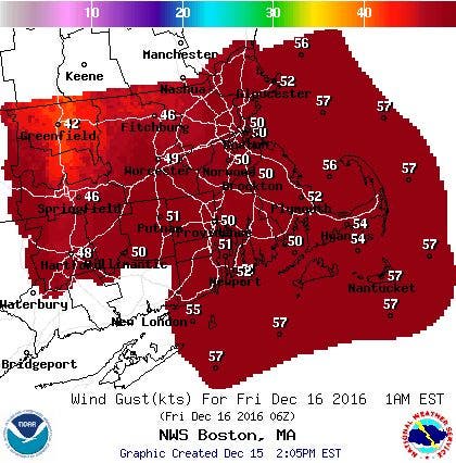
We have already seen some snow squalls pass through parts of Rhode Island this morning, as we await an Arctic front. We will see possible snow showers and squalls through the afternoon and early evening, in advance of some of the coldest air of the season. With winds of 20 mph and gusts of 40 mph, despite temperatures in the middle 20’s, it feels to our skin like the upper single digits. Unfortunately, this will not be a good night to be outside.
Look for any snow squalls or showers to end by midnight, as high pressure builds east. However, this will help strengthen the pressure gradient, causing the strong winds and wind gusts. With winds in the upper levels above us near 50 mph, we could see wind gusts of 50-60 mph at times this evening, as downdrafts help to bring that cold air down to the surface. So, please secure any outdoor furniture, or any Christmas displays that can easily be picked up by the wind. Look for partly cloudy skies with lows falling into the upper single digits. Wind chills will be worst in northwest Providence County, where a Wind Chill Advisory will be in effect from midnight to 9 a.m. Also, a High Wind Warning will be in effect for all of Rhode Island from 5 p.m. until 4 a.m. Friday. With winds of 13-18 mph and gusts possible reaching 60 knots, wind chill temperatures will feel like -10 to -15 below zero for much of the state.
Find out what's happening in East Providencefor free with the latest updates from Patch.
Friday will see sunny skies to start the morning, but the sunshine will be totally ineffective. High temperatures for the day will only reach the upper teens, and wind chills will still be around 10 to 15 below zero. We will see increasing clouds by the afternoon, as the high pressure center moves east. This will allow low level moisture from a low in western Arkansas to move overhead. Light snow will begin to fall south to north by 2 a.m. Winds will also be diminishing, and low temperatures will only fall into the lower teens.
Moving into Saturday morning, we will see all snow until 8 a.m. As winds shift to the southwest, warmer air will begin to move into Rhode Island. So, the snow will begin to mix with a freezing rain, before changing to just freezing rain between 8 a.m. and noon. A warm front from the south will push into Southern New England for the afternoon, changing the precipitation to all rain. We will remain in the warm sector of the storm right into Sunday. Some computer models are showing some drier air may move in Saturday night, creating just scattered showers, or in some parts, just drizzle. Low temperatures will remain warm, with the mercury only falling into the lower 40’s.
The rain will pick up again by Sunday morning, as we await the cold front. We could see almost an inch of rain before the precipitation ends around 8 p.m. Our temperatures will continue to remain warm, as we could see highs in the lower 50’s. A strong high pressure system pushes into southern Quebec, Canada Sunday night, helping to bring partly cloudy skies. However, we will return to more normal low temperatures, as the mercury falls into the lower 20’s.
We will start the work and school week before Christmas with calmer weather and sunny skies. Temperatures, however, will continue to yo-yo, as now highs will only reach 30 degrees. We will keep partly cloudy skies Monday night, with lows in the upper teens. We will lose the Quebec high on Tuesday, but will remain influenced by a high pressure ridge over New England. We keep mostly sunny skies with highs in the lower 30’s. Winds will turn more to the west Tuesday night, helping to raise our temperatures. Expect lows to only be in the lower to middle 20’s under partly cloudy skies.
The deep blast of cold air will have moved off to our east by Wednesday, allowing for warmer air to come up from the south. We will continue to hold on to partly cloudy skies, and our temperatures return to normal conditions, reaching the lower 40’s. We will keep partly to mostly cloudy skies during the daylight hours next Thursday, with highs in the middle 40’s. But, the high will move out to sea, and a new low pressure system will bring some rain by 8 p.m. Thursday night.
Oh, finally, I am able to look ahead and see what Christmas Day what might look like, weather wise. Unfortunately, there will not be a White Christmas this year. In fact, the computer model is showing rain showers and mild conditions for Christmas Day. However, still being 10 days out, things may change.
Jim Laurie is a local meteorologist who earned a B.S. in Meteorology at Lyndon State College in Lyndonville, VT. Jim has fifteen years of professional experience, with eight years in the field of marine meteorology.


