Weather
RI Weather: Winter Weather Advisory To Be In Effect
We will begin to see light snow between 1 and 3 a.m. Snow may be heavy at times Saturday morning. Snow changes to rain by the afternoon.


Weather Forecast & Discussion for Rhode Island on December 17, 2016
“The First Forty-Eight”
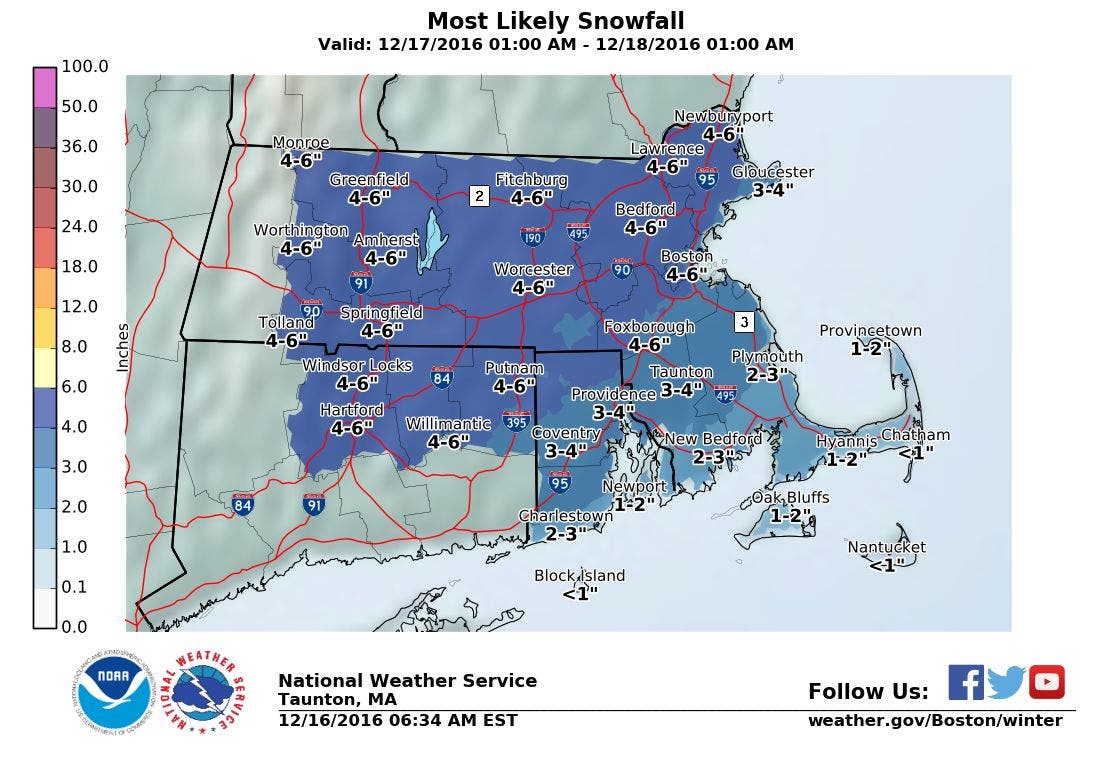
- Saturday: Snow begins around 2 a.m. and becomes moderate to heavy, especially north and west of Providence. Snow will mix with freezing rain by 10 a.m. One to three inches of accumulation is expected along the south coast, with 2-4 inches from Newport into Providence. I am expecting 3-5 inches for the rest of the state. By 1 p.m., precipitation becomes all rain. Temperatures rise into the lower 40’s. Winds S-SSW 6-10 mph. Rain tapers off to showers by the early evening, with drizzle after midnight. Lows will be in the upper 30’s.
- Sunday: Rain returns by 9 a.m., before tapering off to showers after sunset. Highs expected to be in the middle 50’s. Cloudy skies with some clearing by 3 a.m. Lows will fall into the lower 20’s.
Forecast Discussion:
Find out what's happening in East Providencefor free with the latest updates from Patch.
I am updating everyone on the latest weather forecast, as the models are showing a little more accumulation for Saturday. The area that changed drastically was north and west of Providence. For this reason, a Winter Weather Advisory has been put in effect for all of Rhode Island from 4 a.m. Saturday morning until noon. Heavier bands of precipitation will hit this part of the area, once we reach sunrise. For now, snow showers will begin around 2 a.m., and work northward. Snow will become heavier as we enter sunrise, until warmer air begins to raise temperatures. By about 10 a.m., I am expecting a mix of rain and snow to occur, before changing completely over to rain by about 1 p.m. We will remain in the warm sector of the storm right into Sunday. Some computer models are showing some drier air may move in Saturday night, creating just scattered showers, or in some parts, just drizzle. Low temperatures will remain warm, with the mercury only falling into the upper 30’s.
The rain will pick up again by Sunday morning, as we await the cold front. We could see almost an inch of rain before the precipitation ends around 8 p.m. Our temperatures will continue to remain warm, as we could see highs in the lower 50’s. A strong high pressure system pushes into southern Quebec, Canada Sunday night, helping to bring partly cloudy skies. However, we will return to more normal low temperatures, as the mercury falls into the lower 20’s.
Find out what's happening in East Providencefor free with the latest updates from Patch.
We will start the work and school week before Christmas with calmer weather and sunny skies. Temperatures, however, will continue to yo-yo, as now highs will only reach 30 degrees. We will keep partly cloudy skies Monday night, with lows in the upper teens. We will lose the Quebec high on Tuesday, but will remain influenced by a high pressure ridge over New England. We keep mostly sunny skies with highs in the lower 30’s. Winds will turn more to the west Tuesday night, helping to raise our temperatures. Expect lows to only be in the lower to middle 20’s under partly cloudy skies.
The deep blast of cold air will have moved off to our east by Wednesday, allowing for warmer air to come up from the south. We will continue to hold on to partly cloudy skies, and our temperatures return to normal conditions, reaching the lower 40’s. We will keep partly to mostly cloudy skies during the daylight hours next Thursday, with highs in the middle 40’s. But, the high will move out to sea, and a new low pressure system will bring some rain by 8 p.m. Thursday night.
Oh, finally, I am able to look ahead and see what Christmas Day what might look like, weather wise. Unfortunately, there will not be a White Christmas this year. In fact, the computer model is showing rain showers and mild conditions for Christmas Day. However, still being 10 days out, things may change.
Jim Laurie is a local meteorologist who earned a B.S. in Meteorology at Lyndon State College in Lyndonville, VT. Jim has fifteen years of professional experience, with eight years in the field of marine meteorology.


