Weather
Showers End Tonight, But Wind Gusts Continue Saturday; Showers/Rain Possible Sunday
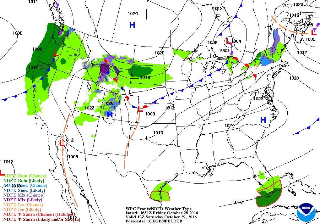
A low pressure system is creating the passing showers and wind at the moment. A new low along a cold front may bring more rain on Sunday.

Weather Forecast Discussion for Rhode Island on October 29, 2016
Most of Rhode Island received between an inch and an inch and a half of rainfall from our low pressure system Thursday and part of Friday morning. That same low is now bringing strong northwest winds of 20-25 mph and gusts of 35 mph. The low’s center will be slowly moving off to the northeast, so we will keep wind gusts of 25-30 mph for tonight. Expect a few showers over northern Rhode Island during the early evening, as it left over from that strong low. Any cloud cover will gradually give way to partly cloudy skies before sunrise. Look for low temperatures tonight to be in the upper 30’s.
A new and fast moving low passing into Quebec Saturday morning will bring back overcast skies through the daytime hours. The precipitation associated with this low should remain over Northern New England. Winds will slowly turn to the southwest, but it will remain breezy, especially during the morning. High temperatures will reach the upper 50’s. Skies become partly cloudy Saturday night, as some drier air moves over New England. With winds still gusting to 20-25 mph and winds coming from the southwest, low temperatures will only fall into the lower 50’s. Limited sunshine is expected on Sunday, as a slow moving low south of Rhode Island may bring some showers and light rain to the area by the mid-afternoon. The precipitation will end after 2 a.m. High temperatures will be in the lower 60’s, with cooler air coming behind the front Sunday night. Low temperatures will fall into the lower 40’s, despite the mostly cloudy skies.
Find out what's happening in East Providencefor free with the latest updates from Patch.
High pressure over Quebec will bring drier air on Halloween, but the north wind will create a cold breeze during the daytime hours. High temperatures will only reach the lower 50’s despite mostly sunny skies. The temperatures will slowly cool into the lower to middle 40’s to near 50 before sunset as our trick-and-treaters make their rounds between 6 and 9 p.m. If you happen to be out at midnight, and see the witches riding on their broomsticks, just yell at them to put on a coat, as low temperatures will fall into the upper 30’s. We will keep mostly sunny skies on Tuesday, as highs reach the upper 50’s. Moisture passing to our north and west will bring overcast skies Tuesday night, but no precipitation. Low temperatures are forecast to fall into the upper 40’s.
A strong high pressure ridge over the Southeast U.S. will keep dry weather over the eastern U.S. On Wednesday, we will see the warmest day of the week, as an upper-level ridge moves over the Northeast U.S. We will see partly sunny skies, with highs in the middle 60’s. We return to partly cloudy skies Wednesday night, with lows in the upper 40’s. We will see the next chance for rain on Thursday, as the computer models disagree on how to handle a cold front. The American model believes a low will move along the front, and bring some significant rainfall. The European model keeps a weak wave of low pressure, giving us isolated showers on Thursday morning. Right now, I feel the American model is overdoing the precipitation, as the United Kingdom model shows a very weak wave of low pressure to our north. For now, I will call for mostly cloudy skies and the risk for passing showers during the morning and afternoon. The upper-level ridge breaks down quickly, as high temperatures only reach the lower 60’s. We will keep mostly cloudy skies Thursday night, with lows in the middle 40’s. Once the cold front passes, high pressure will bring back mostly sunny skies Friday. But, temperatures will be cooler, as high temperatures only reach the middle 50’s.
Find out what's happening in East Providencefor free with the latest updates from Patch.
Jim Laurie is a local meteorologist who earned a B.S. in Meteorology at Lyndon State College in Lyndonville, VT. Jim has fifteen years of professional experience, with eight years in the field of marine meteorology.


