Weather
Supermoon Can Be Seen Until Midnight, Before Rain Arrives
You can still see the supermoon before clouds and showers take over early Tuesday morning. Dry weather returns on Wednesday.

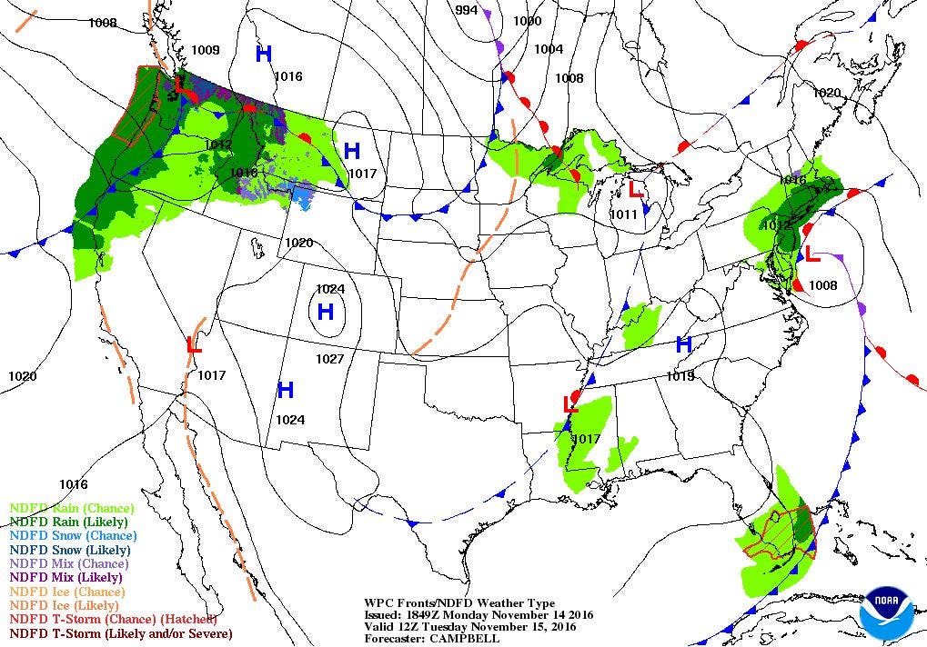

Weather Forecast Discussion for Rhode Island on November 15, 2016
We are experiencing some mild weather over the Ocean State on Monday. Temperatures reached the middle to upper 60’s across Rhode Island, thanks to westerly winds and abundant sunshine. However, we will see some rain on Tuesday, before seeing drier conditions into the weekend.
For tonight, you will still have some time to see the supermoon in the sky before low and mid-level clouds begin to take over. Based on the models, I feel you can still easily see the moon via telescope or your own eyes until midnight. Also, some parts of eastern Massachusetts may see minor coastal flooding, due to the high astronomical tides expected the next two evenings. The cloud cover will come from a low pressure system bringing showers and rain to the Carolinas. The moisture will move in during the overnight, with the threat of showers between 3 to 5 a.m. Low temperatures will reach the lower 40’s. We will see rain through the day, with highs in the middle 50’s. We may see up to a half-inch of rain before showers taper off during the evening. Isolated showers will remain Tuesday night, as the low’s center moves over Northern New England. We will also see patchy fog, and low temperatures in the upper 40’s.
Find out what's happening in East Providencefor free with the latest updates from Patch.
There may be a passing sprinkle when we start off to school or work Wednesday morning, but high pressure ridging will slowly build over the Northeast U.S. So, expect partly sunny skies, with highs in the upper 50’s. Skies will become partly cloudy Wednesday night, with lows in the lower 40’s. High pressure over the Southeast U.S. will bring sunny weather through the rest of the workweek. We can expect sunny weather with highs in the upper 50’s Thursday, and in the lower 60’s Friday. Expect clear skies during the evenings, with lows in the lower 40’s.
The weekend appears to have some precipitation within the forecast. However, the models are disagreeing on the timing of the precipitation. At the moment, the European model predicts some precipitation from a cold front passing through the area will reach us early Sunday morning. But, the American model keeps us under high pressure ridging right into Sunday. Also, we will receive extra moisture from a low pressure system created in the Atlantic moving westward back towards the eastern coastline. The Atlantic low will become the primary low entering next Monday, with widespread showers and increasing winds staying over Rhode Island. At this time, we are still five days away from the weekend, so the models will change their solutions. At the moment, I believe in the American model’s solution, as high pressure ridges weaken more entering the fall and winter season. We will see showers by early Sunday morning, with rain and showers being persist through next Monday. Expect sunshine through most of Saturday, with highs in the lower 60’s. Expect showers before sunrise Sunday, with lows in the lower 40’s. With limited sunshine and northerly winds, highs temperatures Sunday will only reach the lower 50’s.
Find out what's happening in East Providencefor free with the latest updates from Patch.
Jim Laurie is a local meteorologist who earned a B.S. in Meteorology at Lyndon State College in Lyndonville, VT. Jim has fifteen years of professional experience, with eight years in the field of marine meteorology.