Weather
Warmer and muggy once again on Wednesday; Showers and thunderstorms possible Thursday; Autumn weather comes for Friday
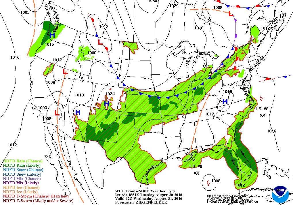
The dewpoint will be rising again by tomorrow, as more moisture comes ahead of a cold front Wednesday night. Rain is possible on Thursday.

Weather Forecast Discussion for Rhode Island on August 31, 2016
After reaching a high of 90 on Monday, north winds last night helped to keep our high temperatures cooler on Tuesday, as we reached 80 at T.F. Green Airport. However, with winds now coming from the south, the dewpoint temperatures will slowly begin to rise this evening. High pressure offshore of Cape Cod will continue moving eastward. So, we will keep partly cloudy skies tonight, with low temperatures in the middle 60’s. Due to the higher dewpoints, late night fog in prone areas is possible.
As we move through Wednesday, we will begin to see the cloud decks in the skies lower, as a weak warm front approaches. With dewpoint temperatures back in the upper 60’s, it will become quite muggy, and high temperatures will reach the middle 80’s. We will be awaiting a cold front to come from the west, and this cold front will help provide us with making the air more unstable. We may see some passing showers by 8 p.m., with an increased risk for scattered showers and isolated thunderstorms through the night. It will remain quite warm, as low temperatures only fall into the upper 60’s. A weak low may form over eastern Massachusetts by the afternoon, but it will not help enhance the precipitation. However, computer models are forecasting areas near the I-95 corridor could see up to 2 inches of rainfall. With winds shifting more to the west, this will cut off the moisture from the south, and allow for some cooler air to return. With the overcast skies, high temperatures will only reach the upper 70’s. Any showers will end by midnight, with slowly clearing skies approaching sunrise. With north winds, low temperatures will fall into the lower 60’s.
Find out what's happening in East Providencefor free with the latest updates from Patch.
As we enter the first half of the holiday weekend, an upper level trough will be over the Northeast U.S. This will allow cooler air down from Canada to remain over the region. High pressure coming down from central Canada will also bring drier air to the surface, giving us mostly sunny skies. However, the air will feel more comfortable, as the dewpoint temperatures will lower into the 50’s. We will keep the autumn like weather into Friday night, as we stay under clear skies, and low temperatures will fall into the lower 60’s. Saturday’s weather looks extraordinary, with bright sunshine and low humidity. High temperatures will only reach the middle 70’s. We will be able to open the windows Saturday night, as low temperatures fall into the upper 50’s under clear skies.
As we enter Sunday, though, there is a little bit of uncertainty with Tropical Depression Nine. Going into Sunday, only the European model believes that T.D. Nine will remain south and east of New England. The American and United Kingdom model feel the high will be placed north and east of the low. Therefore, because low pressure moves towards lower pressure, that placement is back to the north and west. This would bring the tropical towards the Mid-Atlantic Sunday afternoon, and into Southern New England by early Monday morning. Also, the European model actually has the tropical a few hundred miles from Cape Cod, but retrogrades the system back towards Southern New England Monday.
Find out what's happening in East Providencefor free with the latest updates from Patch.
So, there is a lot of different ways to look at what might happen for Monday. At this time, I will call Sunday mostly sunny, as the low will slow down after hitting the high pressure ridge. High temperatures will be near 80. I feel we will see partly cloudy skies Sunday night, with lows in the lower 60’s. We will see mostly cloudy skies to start Labor Day, due to the proximity of T.D. Nine. There may be some showers and isolated thunderstorms during the morning, and it will become breezy. The precipitation and wind slowly dissipates by the mid-afternoon, as the low moves off to the east. We may even see some partial sunshine before sunset. Look for highs to reach the upper 70’s. Also, if you live near the beaches, expect heavy surf and rip currents, starting by Sunday evening.
Skies become partly cloudy Monday night, with lows in the middle 60’s. High pressure over the Southern Plains will bring bright sunshine next Tuesday, with highs in the middle 80’s. Unfortunately, my confidence level in the forecast is low after Sunday afternoon. I am still very unsure what the path of Tropical Depression Nine will be, along with the location of the high pressure system near Maine.
Tropical Update: We still have three tropical systems being watched by the National Hurricane Center at this time. The strongest system, Hurricane Gaston, is 750 miles east of Bermuda, and has maximum sustained winds of 110 mph. The system is caught in the weak cold front that passed through the Ocean State on Monday morning. It will remain a hurricane into Thursday, before hitting cooler waters. It will become a tropical storm by Friday, before completely dissipating by Sunday. In fact, the high surf hitting many Rhode Island beaches at the moment is from the swells of Gaston.
Tropical Depression Eight is just 60 miles south-southeast of Cape Hatteras, North Carolina, with maximum sustained winds of 35 mph. Tropical Storm Warnings are out for the Outer Banks, as the system is forecast to intensify by tomorrow afternoon. This system may dump 3 to 5 inches of rainfall to this part of North Carolina this evening. However, the system will be moving away from the east coast by tomorrow morning, as it enters a frontal boundary. We will likely see the swells from this system reach our beaches by tomorrow evening into Thursday evening. The system will become a mid-latitude system by Thursday evening, and become a post-tropical system by Friday afternoon.
Finally, the one system that is creating the most uncertainty is Tropical Depression Nine. As of 10 a.m. Tuesday, Nine was centered 340 miles west of Key West, Florida. It was possible that a Tropical Storm Watch may be put in effect for the Florida Gulf Coast. The system is forecast to make landfall as a tropical storm early Thursday afternoon over northwest Florida. The system will stay a few hundred miles away from South Carolina Friday morning, before moving out to sea on Saturday. However, many computer models believe it will become stationary, thanks in part to high pressure ridging along the east coast. There is a low confidence in the forecast for Southern New England after Sunday night, as many models bring the low up into Southern New England for Labor Day.
First Pitch Forecast (for McCoy Stadium, home of the Pawtucket Red Sox):
Sept 1st (7:05 p.m. vs. Syracuse): Overcast, possible shower or thunderstorm, 76.
Jim Laurie is a local meteorologist who earned a B.S. in Meteorology at Lyndon State College in Lyndonville, VT. Jim has fifteen years of professional experience, with eight years in the field of marine meteorology.


