Weather
Updated: Latest RI Forecast: Another April Fool's Storm in the Pipeline?
As of early Thursday morning, the forecast calls for a wintry mix in Rhode Island.


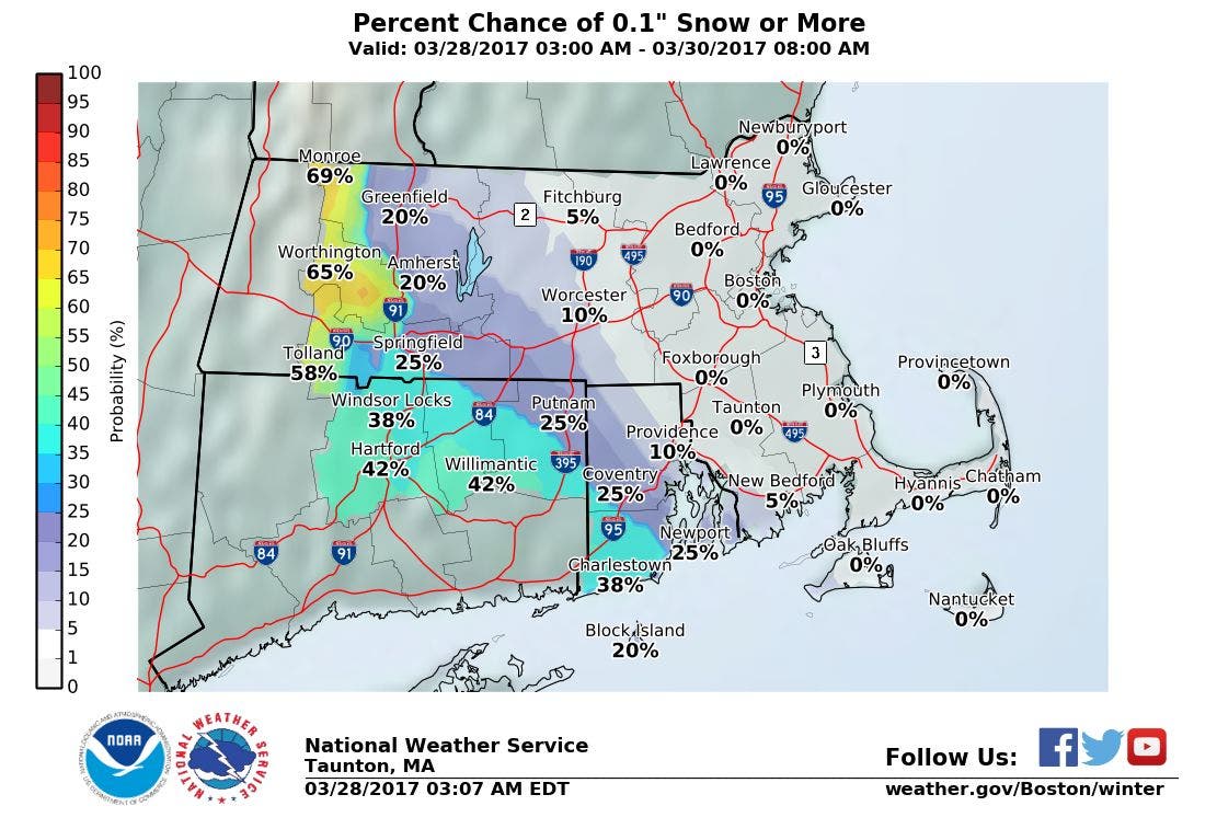
NEWPORT, RI — The National Weather Service says there's a potential for snow, sleet and freezing rain from Friday morning into Saturday morning. Given the time frame, the forecasters are noting they still have some uncertainty. Here are detailed forecasts from Taunton for the north, central and southern parts of the state, as of Wednesday 4:49 p.m.
For Coventry:
Friday
Rain, snow, and sleet likely before 3pm, then snow and sleet likely between 3pm and 5pm, then rain, snow, and sleet likely after 5pm. Cloudy, with a high near 37. East wind 5 to 9 mph. Chance of precipitation is 70%. New snow and sleet accumulation of less than one inch possible.
Find out what's happening in Newportfor free with the latest updates from Patch.
Friday Night
Rain and sleet, becoming all rain after 11pm. Low around 33. East wind around 14 mph. Chance of precipitation is 90%.
Saturday
Rain likely, mainly before 2pm. Cloudy, with a high near 38. Chance of precipitation is 70%.
Find out what's happening in Newportfor free with the latest updates from Patch.
Saturday Night
A chance of rain before 7pm. Mostly cloudy, with a low around 32. Chance of precipitation is 30%.
For Cranston:
Friday
A chance of rain and snow before 10am, then rain likely. Cloudy, with a high near 42. East wind 3 to 7 mph. Chance of precipitation is 70%.
Friday Night
Rain. Low around 35. Chance of precipitation is 90%.
Saturday
Rain likely, mainly before 3pm. Cloudy, with a high near 45. Chance of precipitation is 70%.
Saturday Night
A chance of rain before 7pm. Mostly cloudy, with a low around 33. Chance of precipitation is 30%.
For Woonsocket:
Friday
Rain, snow, and sleet likely before 4pm, then snow and sleet likely between 4pm and 5pm, then rain and sleet likely after 5pm. Cloudy, with a high near 37. East wind around 6 mph. Chance of precipitation is 70%. New snow and sleet accumulation of less than one inch possible.
Friday Night
Rain and sleet, becoming all rain after 5am. Low around 33. East wind around 8 mph. Chance of precipitation is 90%.
Saturday
Rain before 9am, then rain and sleet likely between 9am and 2pm, then rain likely after 2pm. High near 38. Chance of precipitation is 80%.
Saturday Night
A chance of rain and sleet before 8pm. Mostly cloudy, with a low around 29. Chance of precipitation is 30%.
For Narragansett:
Friday
A chance of rain, snow, and sleet before 10am, then rain likely between 10am and noon, then rain and sleet likely after noon. Cloudy, with a high near 39. East wind 6 to 13 mph. Chance of precipitation is 70%. Little or no snow and sleet accumulation expected.
Friday Night
Rain. Low around 36. East wind 15 to 18 mph, with gusts as high as 28 mph. Chance of precipitation is 100%.
Saturday
Rain, mainly before 2pm. High near 39. Breezy. Chance of precipitation is 80%.
Saturday Night
A chance of rain before 8pm. Mostly cloudy, with a low around 34. Chance of precipitation is 30%.
For Newport:
Friday
Rain, snow, and sleet likely before 4pm, then rain and sleet likely between 4pm and 5pm, then rain likely after 5pm. Cloudy, with a high near 39. East wind 5 to 11 mph. Chance of precipitation is 70%. Little or no snow and sleet accumulation expected.
Friday Night
Rain. Low around 35. East wind 13 to 17 mph, with gusts as high as 28 mph. Chance of precipitation is 100%.
Saturday
Rain, mainly before 3pm. High near 40. Breezy. Chance of precipitation is 80%.
Saturday Night
A chance of rain before 8pm. Mostly cloudy, with a low around 33. Chance of precipitation is 30%.
Get more local news delivered straight to your inbox. Sign up for free Patch newsletters and alerts.