Weather
RI Christmas Storm Could Bring Major Power Outages, 70 MPH Winds
National Grid is shoring up its holiday staffing in the event of widespread outages that could last days.


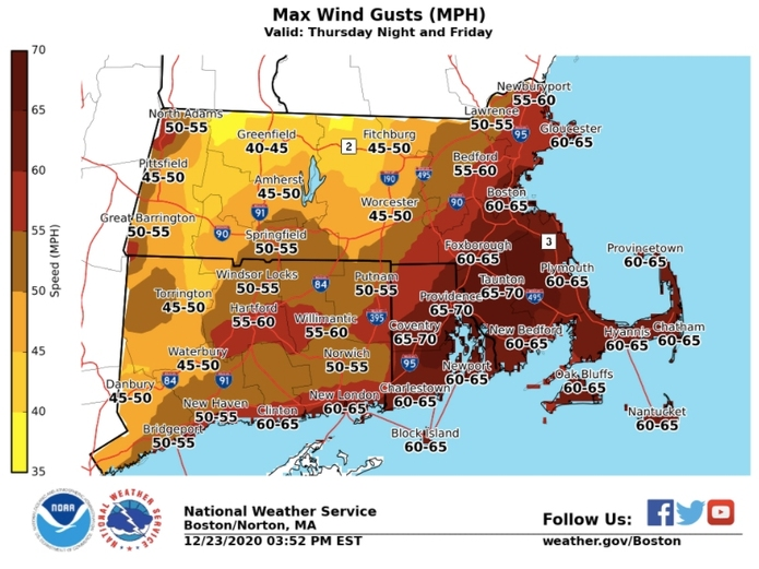
A Christmas storm expected to bring powerful wind gusts could leave many across Southern New England without power for days.
National Grid is preparing for a "multi-day power restoration event," with extra crews on call in case of downed trees and power lines.
"We have canceled employee vacations, secured additional crews, and put emergency plans in place in anticipation of this severe, ill-timed storm," said Michael McCallan, vice president of electric operations for New England. "We’re prepared for the storm and its aftermath. We recognize that no outage is convenient, and we’re particularly conscious of the timing of this storm, when so many of our customers will be celebrating the holidays at home during what continues to be a challenging year."
Find out what's happening in Newportfor free with the latest updates from Patch.
Winds that could gust up to 70 miles per hour are expected to start late Thursday night and persist through Christmas morning, potentially knocking tree limbs and power lines and making for difficult last-second travel. The National Weather Service is putting a high wind warning in effect statewide from midnight to noon Friday.
"Widespread power outages are expected," the Weather Service said in an alert. "Travel will be difficult, especially for high profile vehicles."
Find out what's happening in Newportfor free with the latest updates from Patch.
Flooding is another concern as the storms could bring heavy rainfall. Temperatures will be warm enough — perhaps into the 60s — Friday morning to squash any possibility of a White Christmas.
Here's a look at the latest forecast from the National Weather Service.
Today
Mostly cloudy, with a steady temperature around 51. South wind around 14 mph, with gusts as high as 28 mph.
Tonight
Rain, mainly before 5am, then showers and possibly a thunderstorm after 5 a.m. Patchy fog after 10pm. Temperature rising to around 60 by 4 a.m. Breezy, with a south wind 15 to 24 mph, with gusts as high as 60 mph. Chance of precipitation is 80 percent. New rainfall amounts between a quarter and half of an inch possible.
Christmas Day
Showers and possibly a thunderstorm before 2pm, then rain likely, mainly between 2 p.m. and 4 p.m. Some of the storms could produce heavy rainfall. Patchy fog between 11am and 2pm. Temperature rising to near 62 by 10 a.m., then falling to around 52 during the remainder of the day. Breezy, with a south wind 19 to 24 mph decreasing to 10 to 15 mph in the afternoon. Winds could gust as high as 65 mph. Chance of precipitation is 100 percent. New precipitation amounts between 2 and 3 inches possible.
Friday Night
A chance of rain before 8 p.m., then a chance of showers between 8 p.m. and midnight. Cloudy, then gradually becoming partly cloudy, with a low around 28. Southwest wind 8 to 10 mph, with gusts as high as 22 mph. Chance of precipitation is 30 percent. New precipitation amounts between a tenth and quarter of an inch possible.
Saturday
Mostly sunny, with a high near 35. West wind 8 to 11 mph.
Saturday Night
Mostly clear, with a low around 24. West wind 6 to 9 mph.
Sunday
Sunny, with a high near 38. West wind 6 to 9 mph.
Sunday Night
Partly cloudy, with a low around 28. West wind 3 to 5 mph.
Patch editor Mike Carraggi contributed to this report.
Get more local news delivered straight to your inbox. Sign up for free Patch newsletters and alerts.


