Weather
RI Weather Forecast: Wednesday Storm Looking Worse
Increased snow totals (again) and a timeline of the storm frame a rough Wednesday.


The storm that is expected to bring "a good thump of snow" is expected to arrive overnight, the National Weather Service said. That means plenty of precipitation for the Wednesday morning commute, and up to 6-8 inches in much of the state by the end of the day.
By about 4 a.m., the entire state will be a very wet place. The storm won't begin clearing Rhode Island until late Wednesday afternoon/early evening. The last remnants will be gone shortly after 7 p.m. You can see the forecast radar below to get a better sense of the storm's timing.
The expected snow totals have also risen, according to the NWS. The high-end range of 6-8 inches has now crept into Rhode Island and is expected for most of Massachusetts. The farther south you are, the less snow to expect. A mixture of freezing rain will enter the equation.
Find out what's happening in Newportfor free with the latest updates from Patch.
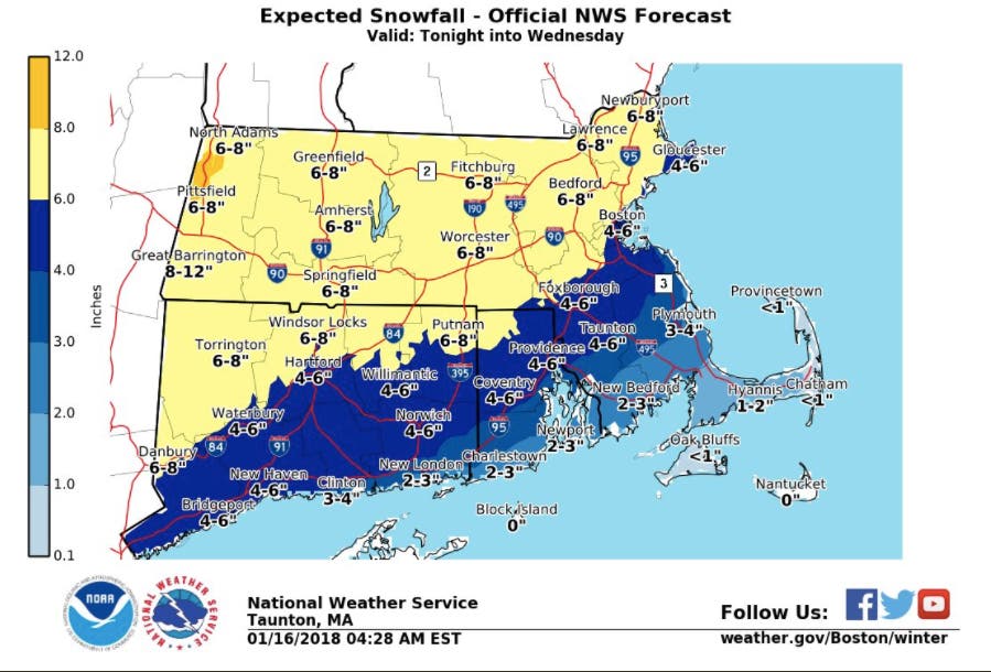
A winter storm warning has been issued for the places expecting to get up to 8 inches, with a winter storm advisory in effect for the rest of the state.
[Tonight - Wed AM] Here is a timeline & precipitation type from one of our models for the upcoming winter weather. A good thump of snow is expected just in time for the Wed AM Commute. Even though it is indicating ice, we believe this is more of a rain/snow event. Plan ahead. pic.twitter.com/cxI9ChgCex
— NWS Boston (@NWSBoston) January 16, 2018
Image via NWS
Find out what's happening in Newportfor free with the latest updates from Patch.
Get more local news delivered straight to your inbox. Sign up for free Patch newsletters and alerts.