Weather
RI Weather Outlook: Monday's Snow Amounts, Timeline
Monday night into Tuesday will be a lot of things, but "dry" isn't one of them.



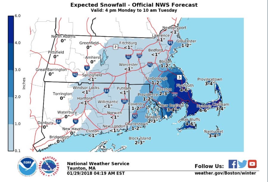
Monday into Tuesday will be a lot of things, but "dry" won't be one of them. Rain will turn to snow and drop anywhere from 2-4 inches across areas of Rhode Island, making the Tuesday morning commute another messy one. The entire state will be under a hazardous weather outlook.
The precipitation begins in the evening coming up from the southeast. Rain will change to snow by the evening and begin moving west around 9-10 p.m., and by midnight some sort of precipitation will cover most of Rhode Island. The National Weather Service says the accumulating snow in Massachusetts will likely be confined to Eastern Mass. See the timeline of the expected rain/snow below.
The NWS doesn't think this has "blockbuster" storm potential, and totals should stay relatively light until you get to Southeastern Mass. Plymouth County and the Cape and Islands can expect between 3-6 inches, but everyone else may get a dusting into Tuesday morning. That doesn't account for the potential rainfall or slushy accumulation, of course.
Find out what's happening in Newportfor free with the latest updates from Patch.
Block Island and Newport may get to worst of it in Rhode with 2-3 inches. Providence and Coventry could see 1-2 inches.
The wind from Monday night to Tuesday morning will be an issue as well. Gusts as high as 40 miles per hour are being forecast for Block Island and some coastal areas could see close to that.
Find out what's happening in Newportfor free with the latest updates from Patch.

While all of Rhode Island will be under a hazardous weather outlook, Massachusetts will be under a few advisories. A winter weather advisory will be in effect for much of south of Boston, including Plymouth County and the Cape and Islands. A hazardous weather outlook will be in effect in Norfolk County. The coast of Boston and north of Boston will be under a coastal flood advisory.
Precip begins as some light rain over the Cape/Islands mid/late afternoon but changes to snow by evening, then expands west across SNE. Accumulating snow likely confined to eastern MA and RI. pic.twitter.com/IZ02l4ungX
— NWS Boston (@NWSBoston) January 29, 2018
Photo by Cameron Kirby on Unsplash
Get more local news delivered straight to your inbox. Sign up for free Patch newsletters and alerts.