Weather
RI Weather: Wind Advisory Issued Ahead Of 'Bomb Cyclone'
The powerful storm is expected to start Wednesday and last into Thursday, bringing several inches of rain and 50 mph wind gusts.


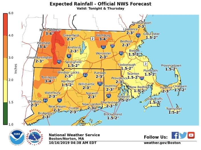
RHODE ISLAND — The National Weather Service issued a wind advisory ahead of a "bomb cyclone" storm expected to slam Rhode Island starting tonight. The advisory, which goes into effect at 10 p.m., lasts until 6 p.m. on Thursday.
Wednesday may have started out with sunny skies, but things are expected to be a lot different by tonight. Rain is expected to start in the late afternoon and evening hours, dumping two to three inches of rain over much of the state throughout the overnight hours and during the day on Thursday.
Both Rhode Island and parts of Massachusetts are under a hazardous weather outlook in advance of the storm. Rhode Island could see winds over 50 mph, with even stronger gusts on Block Island. Power outages and downed trees are possible throughout the state.
Find out what's happening in Newportfor free with the latest updates from Patch.

Patch will be updating power outage numbers throughout the day. Subscribe to your local Patch for information on potential storm damage and power outages.
Here's a look at Rhode Island's latest forecast via the National Weather Service:
Find out what's happening in Newportfor free with the latest updates from Patch.
Wednesday
A chance of rain, mainly after 4 p.m. Increasing clouds, with a high near 61. Southeast wind 7 to 14 mph. Chance of precipitation is 30 percent. New precipitation amounts of less than a tenth of an inch possible.
Wednesday Night
Rain and possibly a thunderstorm, mainly before 4 a.m., then a chance of rain and thunderstorms after 4 a.m. Some of the storms could produce heavy rain. Patchy fog after midnight. Low around 50. Breezy, with an east wind 16 to 24 mph becoming north after midnight. Winds could gust as high as 37 mph. Chance of precipitation is 100 percent. New rainfall amounts between 2 and 3 inches possible.
Thursday
A chance of rain between 9 a.m. and noon, then a chance of showers after noon. Patchy fog before 9 a.m. Otherwise, mostly cloudy, with a high near 55. Breezy, with a west wind 22 to 24 mph, with gusts as high as 49 mph. Chance of precipitation is 30 percent. New precipitation amounts of less than a tenth of an inch possible.
Thursday Night
Mostly cloudy, with a low around 45. Breezy, with a west wind 13 to 20 mph, with gusts as high as 32 mph.
Friday
Mostly sunny, with a high near 58. Northwest wind 14 to 17 mph.
Friday Night
Mostly clear, with a low around 42. Northwest wind 8 to 10 mph.
Saturday
Sunny, with a high near 60. Northwest wind around 7 mph.
Saturday Night
Mostly clear, with a low around 45. West wind around 6 mph.
Sunday
Sunny, with a high near 65. Light west wind becoming southwest 5 to 9 mph in the morning.
Sunday Night
Partly cloudy, with a low around 50. Southwest wind around 6 mph becoming light and variable after midnight.
Get more local news delivered straight to your inbox. Sign up for free Patch newsletters and alerts.


