Politics & Government
Heavy Winds Expected Friday from Hurricane Earl
National Weather Service is monitoring the storm closely.

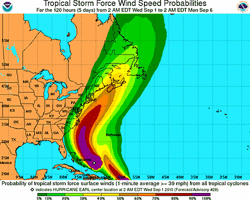


The National Weather Service (NWS) on Wednesday morning tracked Hurricane Earl as a Category 4 hurricane storm with deadly winds of 131-155 miles per hour off the coast of Bermuda, and projected the storm to barrel up the Atlantic seaboard before reaching New England's southeastern islands and coastal communities as a weakened storm system late Friday night.
According to NWS projections, Rhode Island is more likely to experience tropical storm force winds rather than hurricane winds, with the brunt of the storm expected to hit outside Cape Cod and Nantucket Island by 75-100 miles.
A statewide conference call was scheduled for noon for Rhode Island's municipalities and the state's Department of Emergency Management as they monitored the storm's movements closely.
Find out what's happening in Portsmouthfor free with the latest updates from Patch.
"(The projected path) appears to have been moving closer to us over the last few days, so that's something we're watching carefully," said Middletown Emergency Management Director Ronald Doire late Wednesday morning. "Right now, we're looking OK. When it hits Friday night and into Saturday, we're expecting high surf and stormy conditions…with some winds in the 30-40 mph range."
The National Weather Service experts echo locals concerns. NWS meteorologist Kevin Cadima told WRNI Wednesday morning that the possibility remains the hardest hit areas could face hurricane force winds.
Find out what's happening in Portsmouthfor free with the latest updates from Patch.
"A track south of Nantucket would keep the worst of the hurricane force winds out over the ocean but this is a fairly expansive storm," Cadima says. "Even with a track south of Nantucket it would likely bring at least tropical storm force condition across parts of the South Coast, especially Cape Cod and the Islands."
Cadima said residents should closely watch the course of the hurricane, especially as it makes its turn off of North Carolina. A more eastern track would mean less of an impact in Rhode Island. A more western track could be much more substantial.
Right now, local Emergency Management officials are most concerned that Earl may move further inland west, potentially causing heavy flooding and wind damage, and a dangerous and destructive storm surge along Middletown's coastline.
"Our biggest concern are the beaches and low-lying areas," said Doire.
Regardless of how this storm pans out, Doire encouraged local residents to stay informed and prepare for hurricane season sooner rather than later.
The Rhode Island Chapter of the American Red Cross cautioned people against waiting to the last minute to prepare for any natural disaster and encourages all households to take the following three steps:
According to the RI Chapter of the American Red Cross, a recent national survey revealed that only seven percent of Americans have taken the recommended actions to prepare for disasters and Red Cross officials urged the remaining 93-percent to prepare for the unexpected.
Get more local news delivered straight to your inbox. Sign up for free Patch newsletters and alerts.