Community Corner
Beryl's Southern Landfall Doesn't Eliminate Threat to Lowcountry
Wind, isolated tornado activity and rip currents possible.


Update, 5 a.m., May 28:
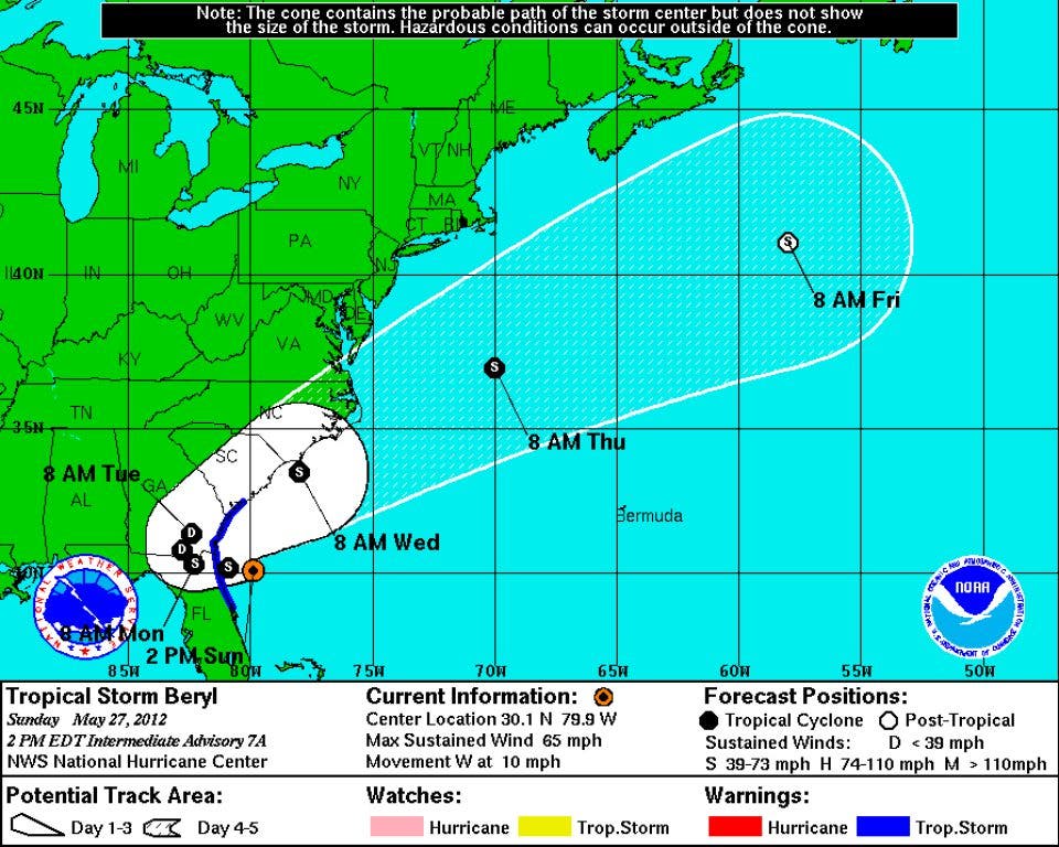
Tropical Storm Beryl continued to press into northern Florida, with sustained winds up to 50 mph. The storm's winds are expected to slow as it continues moving over land.
Forecasts show the storm heading over the Lowcountry late Tuesday night and into the early hours Wednesday morning with sustained winds up to 35 mph. From here, the storm is expected to run back out to the Atlantic and strengthen again over open water.
Find out what's happening in Goose Creekfor free with the latest updates from Patch.
The National Weather Service continues to warn ofdangerous rip currents in the Charelston area due to the storm.
Update, 3 p.m.: Beryl has been upgraded to a tropical storm with sustained winds of 65 mph. The storm is still expected to make landfall near the Georgia/Florida border late Sunday. Gusts of hurricane-force winds are expected as the storm comes ashore.
Find out what's happening in Goose Creekfor free with the latest updates from Patch.
The National Weather Service breaks down the threats from Tropical Storm Beryl for the Lowcountry:
- Winds are expected to gust up to 35 mph through early tonight, along with the possibility of tropical storm winds gusting as rain bands move through the area.
- Storm tide impacts are expected to be low, but there is a small chance for shallow coastal flooding during high tide tonight and early Monday — up to half a foot of water above ground level in low-lying, poorly drained areas.
- Isolated tornado activity is possible with the rain bands from Beryl, particularly stronger showers.
- Rip currents are a significant risk with increasing surf, along with some beach erosion tonight and early tomorrow.
Original Report: Subtropical Storm Beryl has moved closer to shore, staying on track to make landfall sometime Sunday night or early Monday morning near the Georgia/Florida border with sustained winds up to 50 mph.
A tropical storm warning continues for the S.C. coast from Edisto Island down to Jasper County. The tropical storm conditions are expected to begin in the warning area Sunday, according to the National Hurricane Center.
While the Charleston area is no longer under a tropical storm watch, Beryl is expected to turn after it's made landfall and run up the South Carolina coast Tuesday night as a tropical depression.
The NHC continues to warn about dangerous surf conditions from North Carolina down to Florida, with rainfall accumulations in the Southeast ranging from 3-6 inches.
The National Weather Service expects that significant beach erosion will stay south of Charleston and flooding isn't predicted because of current dry conditions.
Continue to monitor your local forecast at the NWS or The Weather Channel.
Get more local news delivered straight to your inbox. Sign up for free Patch newsletters and alerts.