Community Corner
Violent Hurricane Irene Eyes Carolina Coast
Local officials prepare for Lowcountry impact early Saturday.


Aug. 23, 11 a.m.: Updated information on the storm's path can be . Information on local preparations for the storm's impact can be
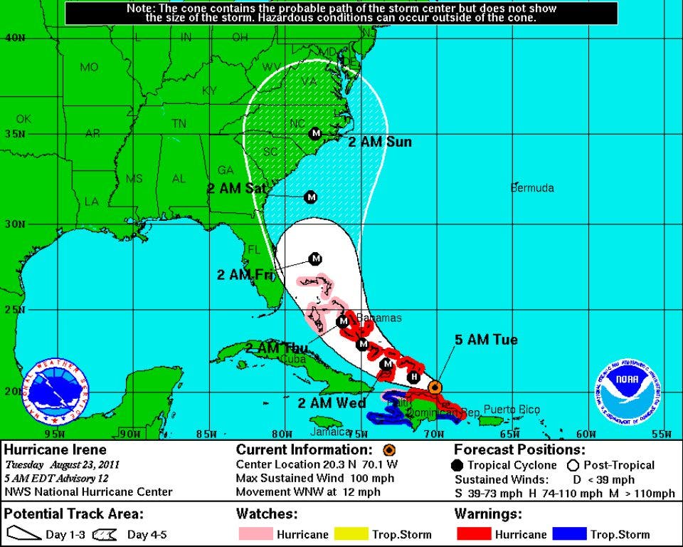
Aug. 23, 5 a.m.: Overnight, the five-day track has shifted slightly north. A Lowcountry landfall remains a possibility, but the current predictions would put the storm roughly 130 miles off the Charleston coast at 2 a.m. Saturday with 120 mph winds.
The storm is still expected to make landfall near the North Carolina/South Carolina border as a Category 3 later Saturday. The National Weather Service is warning of possible tropical storm or hurricane conditions in Charleston.
Find out what's happening in Goose Creekfor free with the latest updates from Patch.
Hurricane Warnings have been issued for portions of the Florida coast. The storm is expected to slowly drag through the Bahamas over the next few days, reaching 135 mph winds by early Friday.
Aug. 22, 11 p.m.: The latest predicted track for Hurricane Irene suggests a slower, stronger storm will be dragging along the coast, while still projected to make landfall at the North Carolina/South Carolina border.
Find out what's happening in Goose Creekfor free with the latest updates from Patch.
The storm is expected to reach 135 mph, a Category 4, by Thursday night. While the storm will then move out into open waters, environmental conditions and the proximity to land is expected to weaken the storm. It is expected to move slowly up the coast with 120 mph winds before making landfall late Saturday at 115 mph, still a major hurricane.
Aug. 22, 8:30 p.m.: A more violent Hurricane Irene is expected to drive up the coast later this week, carrying up to 125 mph winds. The storm is still projected to stay off the coast, but dangerous impacts are still possible for the Lowcountry.
"We can relax a little, but it depends on how far out those winds reach," said Berkeley County Emergency Management Director Tom Smith.
Charleston residents should continue to monitor the storm and continue preparing for severe weather. "While it's too soon to say whether Irene will directly impact the region, probabilities are increasing that tropical storm or even hurricane conditions could occur," according to the National Weather Service.
Aug. 22, 5 p.m.: The latest projected track for Hurricane Irene has the storm running along the Lowcountry coast early Saturday with 115 mph winds before making landfall near the North Carolina/South Carolina border at mid-day.
"Although it is still too early to be certain, the guidance trend continues to lessen the treat to South Florida, but increases the threat to the Carolinas," according to the latest National Hurricane Center update.
Aug. 22, 2 p.m.: Berkeley, Charleston and Dorchester counties are at Opcon 4, preparing for a weekend hit by Hurricane Irene.
That means that emergency operations aren't fully functioning, but local agencies, including law enforcement and municipal officials are coordinating on a potential response and possible shelter plans are under review.
The five-day track for Irene would bring the storm to the Lowcountry shore with 115 mph winds Saturday morning. It is unclear whether the storm will continue to follow that track, but local officials are preparing for the worst.
"There could be different changes to this track, but we need to monitor this very closely," said Cathy Haynes, Charleston County's Emergency Management Department's chief of operations.
She warned residents to also prepare for the storm. "It's important to be prepared for any type of disaster," Haynes said. "Have your family disaster plan. If you haven't written one, now is a good time to do so. If you have written one, now's a good time to take it off the shelf and dust it off and see if there are any changes."
You should also look at creating or refilling your emergency supply kit. More information is available from
Haynes noted that its easy for residents to become complacent after years without a large storm. "Also, in those years, our population has turned over and there may be a lot of citizens in our area with no experience with hurricanes," she said. "Again, it's very important to be prepared."
Aug. 22, 11 a.m.: The latest predictions from the National Hurricane Center suggests Hurricane Irene could make landfall near Charleston on Saturday morning as a Category 3 with 115 mph winds.
Hurricane Irene headed past Puerto Rico on Monday morning, heading for the northern coast of the Dominican Republic. The path is expected to take the storm on to the Bahamas and then into open waters where it would be able to strengthen significantly.
The NHC notes that the five-day forecast for these storms can be wildly imprecise, with a range of 200 to 250 miles.
That said, Lowcounty residents should continue to monitor this storm and make sure they have a hurricane plan, including an evacuation route and a storm kit.
ABC News 4 is reporting that the American Red Cross is preparing its South Carolina volunteers.
The Weather Channel is also following the storm.
Get more local news delivered straight to your inbox. Sign up for free Patch newsletters and alerts.