Politics & Government
Update (4 p.m.): Power Restored to Thousands Across Region
Thousands across the Lowcountry have lost power, according to SCE&G.


Aug. 26, 4:05 p.m.: SCE&G now reports most of Dorechester County's customers have electricity, with only 60 without. Berkeley County, meanwhile, only has 4. Charleston County, meanwhile, still has more than 2,600 without power.
Aug. 26, 4 p.m.: SCE&G is reporting the following power outages around the Charleston area: Charleston County (2,913), Dorchester County (1,889) and Berkeley County (216). An updated weather story is coming soon, with the greatest impact expected in the next few hours.
Aug. 26, 2:05 p.m.: The National Weather Service at 2 p.m. reports some good news. Hurricane Irene's maximum sustained winds have weakened slighty to 100 mph. The storm continues to move north and is expected to pass onto land in North Carolina on Saturday. Later this weekend, the NWS predicts, the storm will move north-northeast.
Find out what's happening in Goose Creekfor free with the latest updates from Patch.
Aug. 26, 2 p.m.: There are now more than 5,800 SCE&G customers without power in Charleston, Dorechester and Berkeley counties. Are you one of those? Where do you live?
Aug. 26, 1:55 p.m.: With so many schedule changes because of the storm, we have created a new . Email us at sc1reg1@patch.com if you have an event that is being called off or rescheduled.
Find out what's happening in Goose Creekfor free with the latest updates from Patch.
Aug. 26, 1:05 p.m.: A special alert from the National Weather Service: "Rain bands from Hurricane Irene will routinely push onshore and affect locations primarily to the east of Interstate 95 through 5 p.m. Brief gusty winds of 45-55 mph, with locally higher gusts, along with heavy rainfall reducing visibilities to a quarter mile or less can be expected as the rain bands move though the area."
Aug. 26, 11:15 a.m.: Rain bands have been chasing amateur storm watchers off the beach this morning. There are reports on Twitter of a kiteboarder in distress off the Isle of Palms. SCE&G reports 4,391 currently without power in Charleston and Berkeley counties.
Aug. 26, 8:30 a.m.: Berkeley County schools are now on a half-day schedule as tropical storm force gusts begin to move into the Lowcountry. Charleston County schools took the whole day off.
SCE&G is responding to downed power lines that blocked access to Folly Beach on Monday morning. The utility tweeted, "SCE&G on the scene to clear pole -Folly at Crosby. Replacement pole on the way now. Cause: high winds."
The power company was reporting 2,613 without power in Charleston County and 152 without power in Berkeley County.
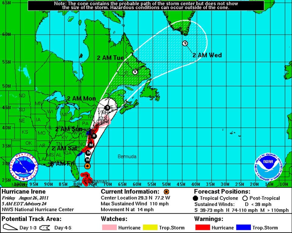
Aug. 26, 5:30 a.m.: Hurricane Irene currently has sustained winds of 110 mph, a strong Category 2, as it churns through open waters this morning more than 200 miles east of the Florida coast.
The latest projections suggest landfall in North Carolina Saturday afternoon as a Category 3 storm with 120 mph winds. The storm is then expected to run up the coast, impacting the Northeast.
The latest estimates from the National Hurricane Center keeps the storm between 170 and 200 miles off the Charleston coast as it moves up the Atlantic today. The National Weather Service warns not to put too much attention on the eye of the storm. "Impacts will be felt well away from the center," according to the latest alert.
Charleston County Schools and county offices are closed Friday as a precaution.
The National Weather Service is forecasting likely tropical storm conditions for the Charleston region today through Saturday morning. Wind gusts could reach 48 mph today, with showers and thunderstorms likely after 11 a.m. As the storm passes Saturday, wind gusts are expected to lessen to 38 mph.
The Weather Channel is also monitoring the storm.
SCE&G has information for you if you lose power.
Get more local news delivered straight to your inbox. Sign up for free Patch newsletters and alerts.