Weather
Central Texas Region Under Flash Flood Watch
National Weather Service issues alert ahead of Friday, when a 100 percent chance or rain, some heavy, is expected to descend on region.


AUSTIN, TEXAS — Travis County and surrounding Central Texas counties are under a flash flood watch ahead of expected heavy rainfall on Friday, according to National Weather Service officials.
The flash flood watch is in effect until Saturday at noon.
"A cold front and potent upper level system are forecast to move across the area and produce locally heavy rainfall Friday afternoon into Saturday morning," Austin weather forecasters wrote on their website. "Rainfall amounts of 3 to 5 inches are expected across the eastern Hill Country and along the Interstate 35 corridor and 4 to 6 inches east of Interstate 35 and Interstate 37."
Find out what's happening in Austinfor free with the latest updates from Patch.
There's nothing speculative about the rain coming on Friday, with a 100 percent chance being forecast. That rainfall is expected to come to an end by Friday night, forecasters added, and should clear entirely by Saturday morning.
Nat'l Weather Service forecasts 3-6" of rainfall for Austin tomorrow through Saturday. If you see water over the road, PLEASE remember: Turn Around, Don't Drown! Texas leads the nation in flood deaths & the majority (>75%) of these deaths happen on the road.
— ATXfloods (@ATXfloods) December 6, 2018
But in the meantime, residents should take precautions. Light rain throughout the region on Thursday served as precursor of what's to come, which should prompt some to pick up any needed rations — bottled water, groceries and, for many of us, the necessary stock of coffee to ensure a steady stream of the stuff — to hunker down ahead of Friday's big storms.
Find out what's happening in Austinfor free with the latest updates from Patch.
It's been said many times, yet often the advice not heeded: Turn Around, Don't Drown. It's not just an empty slogan. Raging flood waters can be deceptively strong, and drivers often risk crossing past them — often with tragic results. Consult ATXfloods.com for a list of closed low-water crossings to avoid in the region.
#ATXWX Alert: @NWSSanAntonio has issued a Flash Flood Watch for Travis and many surrounding Central Texas Countys until Saturday 12:00 PM CST. Stay tuned to local forecasts for updates. Monitor https://t.co/QVX0Fzrjva for road closures. "Turn Around Don't Drown" #TADD pic.twitter.com/aVahBdliJ7
— ATCEMS (@ATCEMS) December 6, 2018
In providing a visual illustration of the looming threat, the National Weather Service created a map showing regions covered under the flash flood watch, with dark green hues denoting affected areas.
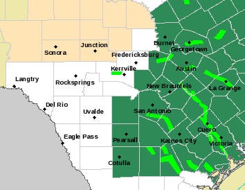
Map via National Weather Service
A flash flood watch is issued by the National Weather Service when conditions are favorable for flash flooding in flood-prone areas, usually when grounds are already saturated from recent rains, or when upcoming rains will have the potential to cause a flash flood.
On Thursday afternoon, the forecast calls for scattered showers and thunderstorms, then showers likely and possibly a thunderstorm after 3 p.m. It's going to be cloudy with a high temperature near 60 degrees and an all but imperceptible northeast wind of around 5 miles per hour. The chance of precipitation on Thursday is a robust 60 percent, with new rainfall amounts of less than a tenth of an inch, except for higher amounts possible in thunderstorms.
By Thursday night, more showers and possibly a thunderstorm are being forecast. The low will be around 53 degrees, with a north wind of between 5 and 10 miles per hour. The chance of precipitation increases to 80 percent, with new rainfall amounts between a quarter-of-an-inch possible.
After that, Mother Nature won't be kidding around. Here's the weekend rundown from the National Weather Service:
- Friday: Showers and possibly a thunderstorm. Some of the storms could produce heavy rainfall. High near 56. North wind around 10 mph. Chance of precipitation is 90%. New rainfall amounts between 1 and 2 inches possible.
- Friday night: Showers and possibly a thunderstorm. Some of the storms could produce heavy rainfall. Low around 47. North northeast wind around 10 mph. Chance of precipitation is 100 percent.
- Saturday: Mostly cloudy, with a high near 53. North northwest wind 10 to 15 mph, with gusts as high as 20 mph.
- Saturday night: Mostly cloudy, with a low around 39. North northwest wind around 10 mph.
- Sunday: Partly sunny, with a high near 51. North wind 5 to 10 mph.
- Sunday night: Mostly clear, with a low around 35. North wind around 5 mph.
As you can see from the map below, only parts of Texas and a swath of Louisiana are under threat of flooding. So take cover, folks. And, please, don't take unnecessary risks while driving on Friday.
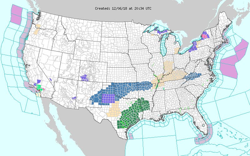
Map via National Weather Service
Get Patch's Daily Newsletters and Real Time Alerts
>>> Image via Shutterstock
Get more local news delivered straight to your inbox. Sign up for free Patch newsletters and alerts.


