Home & Garden
Arctic Blast Puts Northeast In Deep Freeze; Midwest Hit with Snow
Arctic air over the northeast U.S. is being brought in by high pressure in the east.

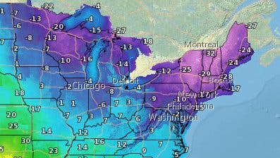
Bone-chilling temperatures enveloped the Northeast United States on Valentine’s Day, breaking records for the coldest temperatures in at least four states while the Midwest faced snow and slick roads. The National Weather Service said the coldest air mass of the season would creep away from the Northeast and give way to snow and freezing rain starting Monday.
New records were set in Boston, Hartford and Providence, where the previous coldest temperatures date back to the 1930s for Boston and the 1970s for Hartford and Providence, according to NWS Boston. Some of the coldest recorded wind chills in the area ranged from -35 in Bedford, MA, to -44 in Worcester, MA, which is located roughly 90 minutes west of Boston.
Gusty winds combined with low temperatures from the cold airmass created dangerous wind chill conditions.
Find out what's happening in Across Americafor free with the latest updates from Patch.
In New York, the NWS reported new or tied records in all six of its major climate sites. The recorded temperatures were:
Find out what's happening in Across Americafor free with the latest updates from Patch.
- Central Park, NY : -1
- Islip, NY : 0
- Bridgeport, CT: -6
- Kennedy, NY : 1
- LaGuardia, NY: 1 (Tied)
- Newark, NJ: 0 (Tied)
Wind chill warnings and advisories were issued for the affected areas.
“Arctic air will be the big story across the northeastern U.S. through Sunday night. An eddy of the polar vortex over southeastern Canada, along with strong cold air advection, is bringing the coldest weather of this winter season from the Great Lakes to New England,” the NWS writes.
The Weather Channel explains that the Arctic air bringing some of the coldest temperatures to the Northeast have been brought in by strong high pressure in the east. The high-pressure system will first impact the midwest, where snow is already falling Sunday in many states including Minnesota, Iowa, Missouri, Indiana and Western Kentucky.
Anywhere between two to five inches of snow was expected in the Chicago area on Sunday. In Central Indiana, slick roads were blamed for a multi-vehicle pileup involving at least 16 cars. Snow in the Midwest is expected to taper off by the evening.
Officials warned residents to stay indoors because of the dangers associated with the extreme cold including hypothermia and frostbite.
In New York City, mayor Bill de Blasio told residents the best thing to do is to stay indoors and to limit exposure when going outside.
While the current forecast calls for extremely cold temperatures, this will not be the case for Monday when a “variety of precipitation types” is expected in the eastern U.S. According to the NWS, snow is likely in far inland portions of the mid-Atlantic and the interior northeast, the Gulf Coast states and the southeast Coast will see rain while freezing rain and sleet is expected in the corridor from western North Carolina through central Maryland.
According to the Weather Channel, this is a modest snow event for mid-February standards.
Image via NWS
Get more local news delivered straight to your inbox. Sign up for free Patch newsletters and alerts.


![Kindness Has Limits When It Comes To Lying, Readers Say [The Question]](https://patch.com/img/cdn20/shutterstock/790386/20260701/084908/styles/patch_image/public/shutterstock-252136366___01204632320.jpg)