Weather
Hurricane Michael Targets Gulf; NoVA, DC Likely To Get Rain
Hurricane Michael should hit the Gulf Coast Wednesday as a category 3 or 4 storm and dump rain on NoVA and DC by Thursday.

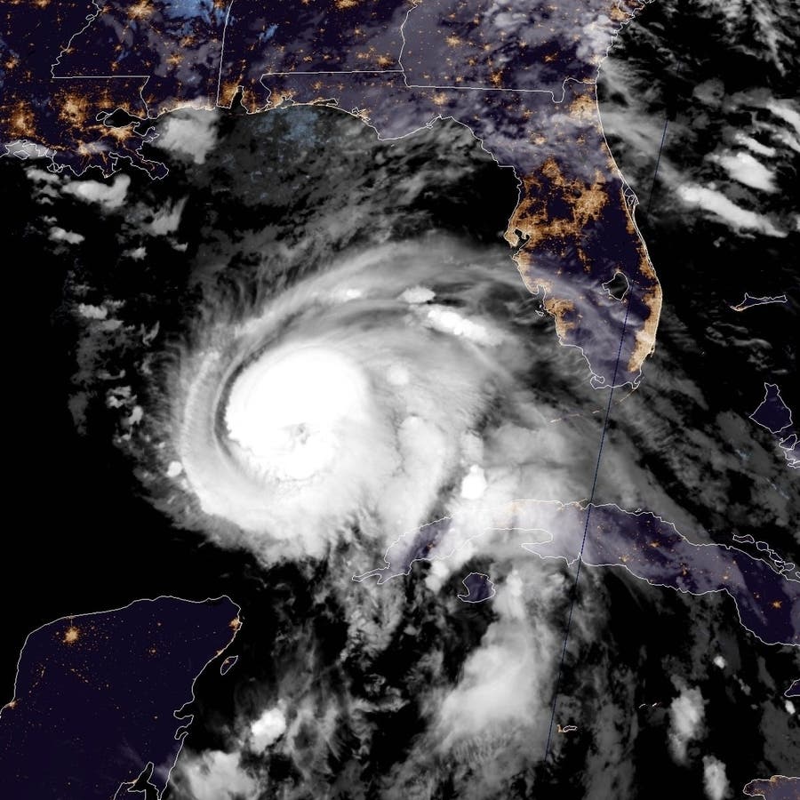
WASHINGTON, DC — The vestiges of Hurricane Michael are expected to dump rain on northern Virginia and Washington, D.C., late Wednesday into Thursday after striking the Gulf Coast, forecasters say. The now category 3 hurricane with 120 mph winds has already caused thousands of people to evacuate throughout Florida, and 92 Georgia counties are under a state of emergency as Michael gains strength in the warm Gulf waters, according to the National Hurricane Center. The latest projections call for the storm will be a "dangerous major hurricane" when it approaches the Alabama-Florida coastline Wednesday, weather officials warned, and a Fairfax County team is on its way to help with rescues.
The National Hurricane Center said Michael could be a Category 4 hurricane with 120-mph winds by the time it reaches the Panhandle. Gov. Rick Scott has declared a state of emergency for numerous Florida counties. Forecasters expect the storm will continue traveling up into Georgia, the Carolinas, Virginia and Maryland. While it's still too early to say for certain where the storm's path will end up, states as far north as Pennsylvania and New Jersey could be affected.
By Thursday, heavy rains from the hurricane will push into the Mid-Atlantic states, says the Weather Channel. The rain is expected to reach the Mid-Atlantic, including North Carolina, Virginia, Maryland and Washington, late Wednesday night into Thursday before leaving by Friday, The Washington Post says.
Find out what's happening in Fredericksburgfor free with the latest updates from Patch.
Maryland Task Force One and the Fairfax County-based Virginia Task Force One headed to the Southeast coast Tuesday morning, reports WTOP, to help in rescues as needed, as it did during Hurricane Florence in North Carolina. Each team travels with rescue equipment, boats and medical equipment.
Tropical storm force winds — in the 40 to 70 miles per hour range — are possible in southeast Virginia late Thursday into Friday, according to the National Weather Service office in Wakefield. The office says there's a lot of uncertainty in the storm's path at this point, and it urges Virginians to remain alert to updates.
Find out what's happening in Fredericksburgfor free with the latest updates from Patch.
SEE ALSO: Hurricane Michael: NoVA Water Rescue Team Heads To Gulf Region
Heavy rainfall is likely at times Thursday into Friday as a cold front and the remnants of Michael move through the region, The Washington Post's Capital Weather Gang predicts. The National Weather Service calls for an 80 percent chance of rain after 8 a.m. on Thursday, dropping to 60 percent Thursday night, and then 30 percent on Friday as fall arrives. The weekend could be perfect with humidity gone and highs in the 60s.

(For more news like this, find your local Patch here. If you have an iPhone, click here to get the free Patch iPhone app; download the free Patch Android app here. And like Patch on Facebook!)
Michael is expected to strengthen into a Category 2 hurricane before making landfall along Florida or Alabama in the middle of this week, AccuWeather senior meteorologist Kristina Pydynowski writes. While Michael will have lost most of its punch, it's expected to bring a fair amount of rain to the area — up to 4 inches, according to the National Hurricane Center's latest projection.
Florida has already started making preparations for the storm. Gov. Rick Scott said Sunday he will issue an executive order declaring a state of emergency for counties in the Florida Panhandle and Big Bend. This means state and local officials will have time, resources and flexibility to adequately prepare, he said.
The storm is moving north at about 7 mph and is expected to pick up speed in the coming days.
"On the forecast track, the center will move through the Yucatan Channel Monday morning and then across the eastern Gulf of Mexico late Monday through Wednesday," the hurricane center wrote.
The Florida Keys could see between 2-4 inches through Monday as well from the storm's outer rain bands.
Hurricane Preparation Tips
- Get Prepared: Take action now to be prepared for hurricanes. As the storm approaches, it is often too late to get ready. Make sure you have family evacuation and communications plans, update your emergency supply kit, and evaluate your flood insurance needs.
- Complete a family communication plan. Plan how you will assemble your family and loved ones and anticipate where you will go for different situations. Get together with your family and agree on the ways to contact one another in an emergency and identify meeting locations.
- Create or restock your emergency kit. Being prepared means having your own food, water and other supplies to last for at least 72 hours. A disaster supplies kit is a collection of basic items your household may need in the event of an emergency, including an all weather radio.
- Check your insurance coverage. Most homeowner's insurance policies do not cover damage or losses from flooding. Review your policy, ensure you're adequately covered and understand exclusions, and contact your agent for any changes.
- Stay Informed. Know where to go for trusted sources of information during a hurricane event. Monitor local news resources for hurricane watches and warnings and follow directions of local officials.
- Determine Your Risk. Find out what types of wind and water hazards are likely in your area. Hurricanes are not just a coastal problem and their effects can reach hundreds of miles inland. Since the U.S. has not been hit by a major hurricane (category 3 or higher) in over a decade, "many people are suffering from hurricane amnesia in the forms of complacency, denial and inexperience."
- Develop an Evacuation Plan. Find out if you live in a storm surge hurricane evacuation zone or if your home is unfit to keep you safe in a hurricane. Speak with family and friends and work out a plan to use their home as an evacuation destination. Be sure to account for pets, since many shelters do not allow them.
- Assemble Disaster Supplies. Supplies are necessary not just for the storm itself, but for the often long and grueling aftermath. Stock up on non-perishable food, water and medicine to support your family for at least a week. Other recommended items are cash and battery-powered radios and flashlights. Since many of us use cell phones, have a solar-powered or hand-crank USB charger.
- Know Your Risk and Plan Ahead for an Evacuation:
- Know how to receive information including recommendations or orders to evacuate.
- If you plan to go to a shelter, notify staff of any special needs you or your family have.
- Do not return to the evacuation area until the evacuation order is lifted.
Get Tech Ready
Technology has made it easier to prepare for emergencies, but it can be unreliable during big storms if you haven't planned to keep your gadgets protected and powered up. Here are some tips to make sure you are tech ready:
Be Informed
Here are basic commands to get started:
- Download the FEMA app. Receive weather alerts from the National Weather Service for up to five different locations anywhere in the United States. To search for open shelters (for disaster survivors): text SHELTER and to 43362 (4FEMA).
Make A Social Media Plan
Use text messages, social media and email to connect with friends and family during emergencies.
- Mobile networks can become overwhelmed during emergencies, making it difficult to place and receive phone calls. Text messages require less bandwidth, which means they are able to be transmitted more reliably.
- Social media channels such as Facebook and Twitter can also be an effective way to update family and friends during emergencies. Facebook's Safety Check feature allows users to easily post a status update indicating that they are safe during a time of disaster.
- Register with American Red Cross's Safe & Well site to let family and friends know you're okay.
- Have an emergency charging option for your phone and other mobile devices. Smartphones have become a vital tool to receive emergency alerts and warnings,, so it's important to make sure you can keep them powered up in an emergency.
- At home: Before severe weather, charge all of your electronic devices. If the power goes out, preserve battery power by minimizing device use. Keep a back-up power source on hand to recharge your phone so that you can stay connected even during an extended power outage.
- In your car: Keep a portable phone charger in your vehicle at all times, and consider purchasing a back-up power supply to keep in your vehicle as well.
- Change the settings on your phone to low power mode or place it on airplane mode to conserve energy.
- Store important documents in a secure, password-protected jump drive or in the cloud.
- Capture electronic versions of important documents such as insurance policies, identification documents, and medical records. Don't forget to include your pet's information.
- Back-up your computer to protect photos and other personally important electronic documents.
- Scan old photos to protect them from loss.
- Keep your contacts updated and synced across all of your channels, including phone, email and social media. This will make it easy to reach out to the right people quickly to get information and supply updates. Consider creating a group listserv of your top contacts.
- Create a group chat via a texting app or a thread for family/friends/coworkers to communicate quickly during a disaster.
- Sign up for Direct Deposit and electronic banking through your financial institution so you can access your payroll funds and make electronic payments wherever you are. Federal benefit recipients can sign up by calling (800) 333-1795 or at GoDirect.org.
- Residents readying for a storm can get tips and advice on the federal government's Ready.gov website. To keep up with potential storms during hurricane season, bookmark the National Hurricane Center's website. For local weather and severe weather alerts, visit the National Weather Service online.
Graphics courtesy of the National Hurricane Center
Get more local news delivered straight to your inbox. Sign up for free Patch newsletters and alerts.