Weather
6 Inches Of Snow Possible By Monday: Puget Sound Forecast
Seattle, Bellevue and Tacoma could each pick up a few inches of snow by Monday evening, followed by severe cold. Here's the latest forecast.


SEATTLE — The forecast is shaping up nicely for a snowy Christmas weekend, with the latest models showing good odds for a few inches to fall across Puget Sound through Monday evening. The National Weather Service shared updated projections on Christmas Eve, highlighting a most likely scenario for 6 inches of snow around Seattle, Bellevue and Tacoma over three days.

Due to the nature of the incoming weather system, confidence in specific snow totals is still relatively low and could vary considerably between communities. A winter weather advisory will be in place until late Sunday afternoon.
⚠️ Important note about this snow event: we expect snow showers and snow bands rather than widespread constant snow for most areas. This will lead to highly variable snow totals. Some areas may get hit, some may get missed. Unfortunately it's the nature of the beast. #wawx
— NWS Seattle (@NWSSeattle) December 24, 2021
For timing, forecasters still see Christmas evening as likely to mark the transition from rain to snow, with accumulations building through Sunday. Currently, the National Weather Service expects any snowfall will occur "within waves of light precipitation," but forecasters are not ruling out the potential for heavier bands or a convergence zone developing, which could boost snow totals for some communities.
Find out what's happening in Seattlefor free with the latest updates from Patch.
Record snow stats for Christmas day through the weekend. Seattle (Sea-Tac)…Dec 25th 1.0" (2017), 26th 8.8" (1974), 27th 1.2" (1965) Bellingham...Dec 25th 8.4" (1971), 26th 0.6" (1965), 27th 5.5" (1965) Olympia...Dec 25th 1.1" (1954), 26th 8.3" (1974), 27th 3.6" (1974). #wawx
— NWS Seattle (@NWSSeattle) December 24, 2021
Monday will mark the beginning of a prolonged period of unusually frigid temperatures for Western Washington, bringing Puget Sound its coldest air of the season so far and possibly its lowest temperatures in more than a decade. Forecasters expect highs will struggle to escape the 20s throughout next week, with overnight temperatures dipping into the teens or lower.
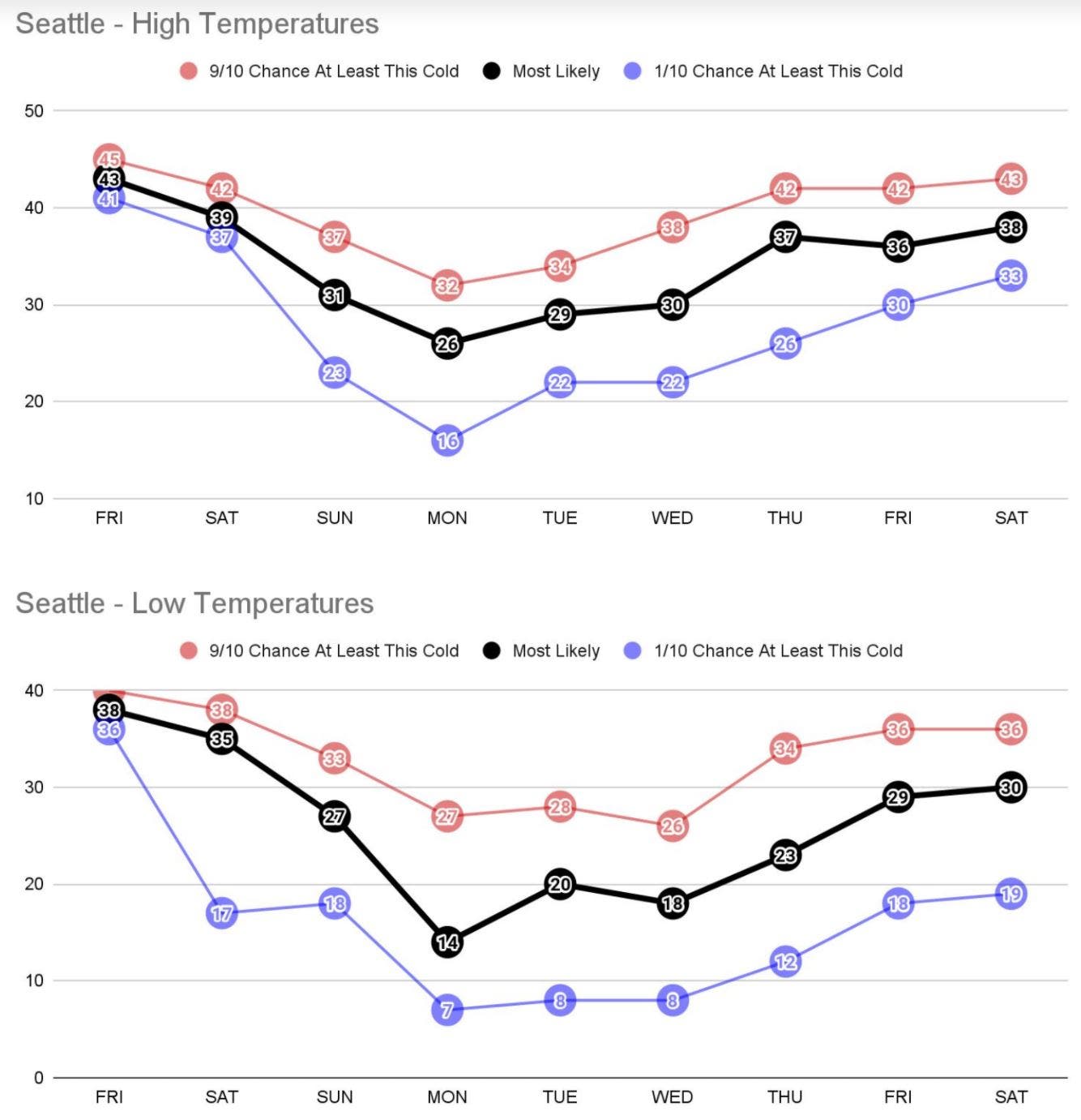
The arctic chill could stick around through New Year's Eve, and forecasters are tracking the potential for more moisture late next week, which could bring a second run of lowland snow across the region. More details on next week's weather will be available as the forecast firms up in the coming days.
Find out what's happening in Seattlefor free with the latest updates from Patch.
It's going to be very cold in WA for the next several days. A community warming center can give you needed relief from the chilling temperatures. Call 2-1-1 to find one or visit the 211 Emergency Shelters page for more information, https://t.co/Bp91IIeKyA. pic.twitter.com/6V36IRYafh
— WA Dept. of Health (@WADeptHealth) December 24, 2021
Now is the time to prepare for cold. Protect you home, your pets, and your car from the cold. Know the signs of frostbite & hypothermia! #wawx pic.twitter.com/B60wsbvzqz
— NWS Seattle (@NWSSeattle) December 24, 2021
Get more local news delivered straight to your inbox. Sign up for free Patch newsletters and alerts.