Weather
Arctic Air, Lowland Snow Headed For Puget Sound: Forecast
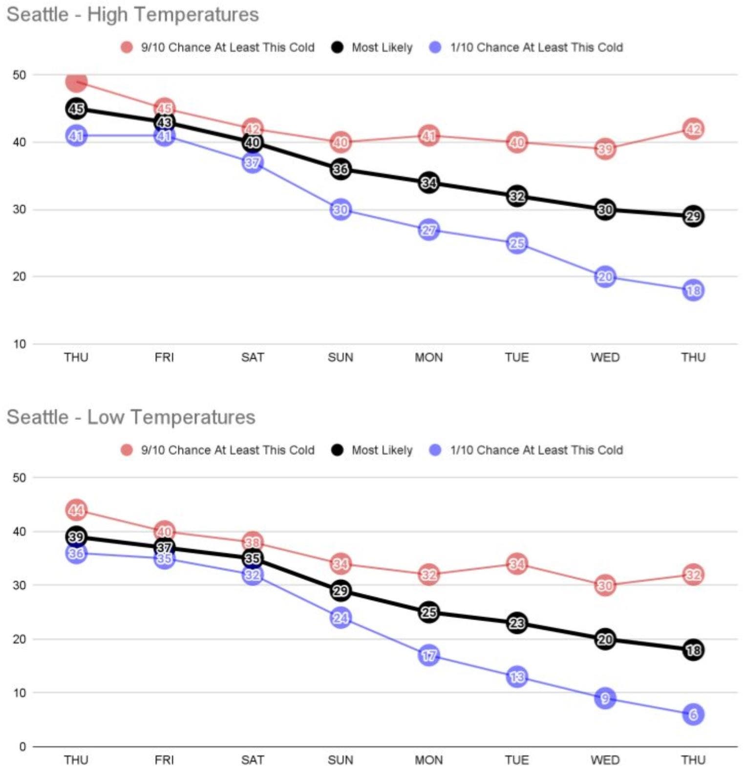
Temperatures may struggle to escape the 20s in the days after Christmas, and it will be cold enough for lowland snow well into next week.


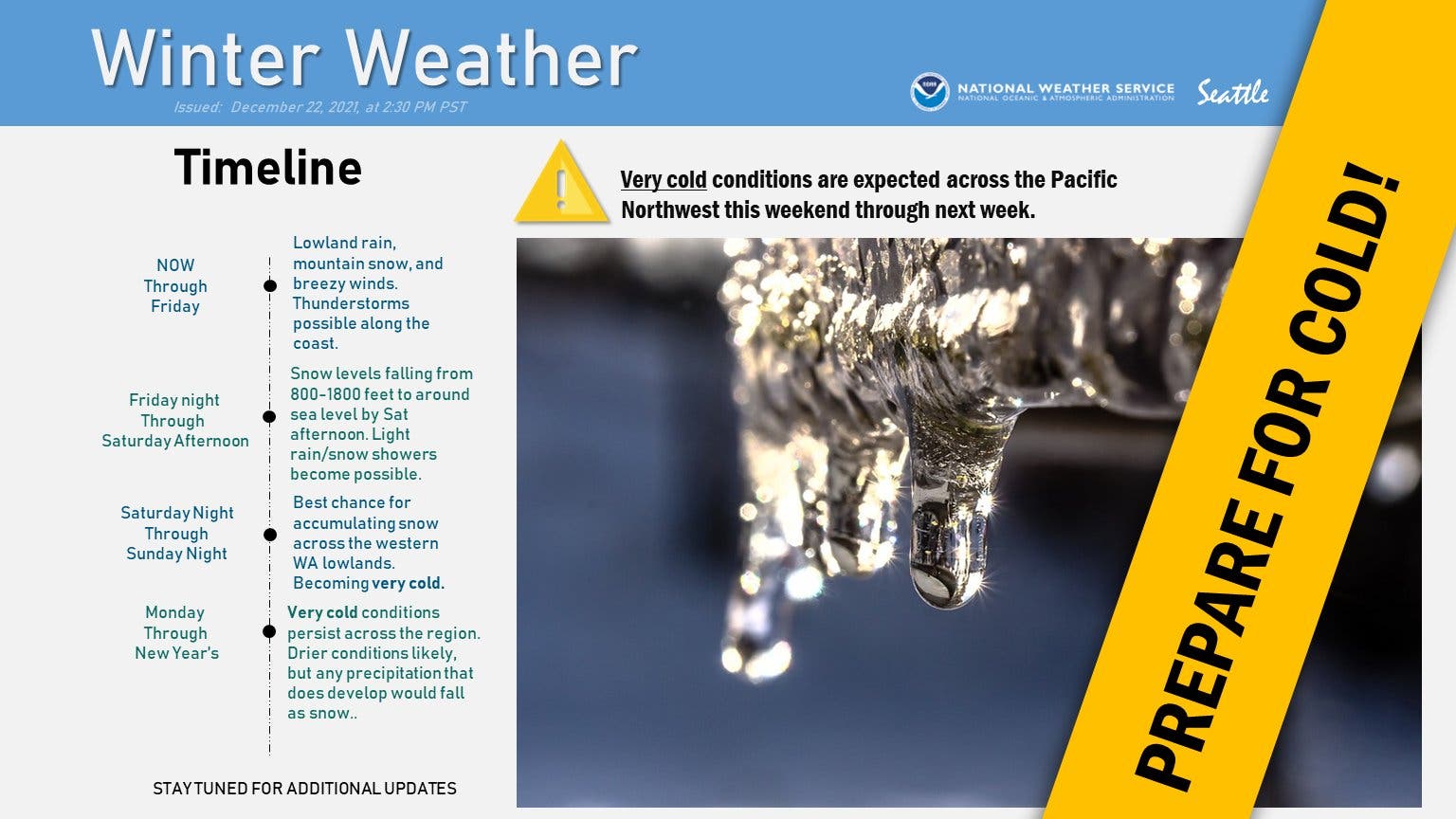
SEATTLE — Winter is officially underway and Western Washington is already heading for a stretch of unusually cold temperatures stretching well into next week, according to the latest forecasts.
The National Weather Service warns that arctic air will bring the coldest days of the season after the holiday weekend, with afternoon temperatures potentially dipping into the 20s for some by next Tuesday. Forecasters said overnight lows could even tumble into the teens by late next week, and there is a smaller chance they will fall into single digits.
Such frigid temperatures will present a significant danger to people experiencing homelessness, pets, and anyone without adequate heating, and lend to frozen pipes. As KUOW reports, homeless advocates gathered outside Seattle City Hall over the winter solstice to read the names of 178 unhoused people who died this year and call on local leaders to quickly stand up warming shelters for the cold days and night ahead.
Find out what's happening in Seattlefor free with the latest updates from Patch.
The city of Seattle announced two shelter locations Wednesday, which will operate from Christmas Day until at least Wednesday, Dec. 29.
Several lowland snow chances from Christmas onward
Find out what's happening in Seattlefor free with the latest updates from Patch.
Forecasters are still keeping a close eye on lowland snow, with current estimates placing the earliest chance for Seattle arriving around Christmas night.
"For those wanting snow, Saturday night through Monday appears more promising right now, [though] subject to change of course," wrote Carly Kovacik, a lead forecaster at NWS Seattle. "If temps are cold enough and snow can materialize, a few inches of accumulation seems like a reasonable outcome. Another factor during this timeframe will be the extent of drier air associated with the colder airmass. It still remains possible that the arctic air could push the moisture south faster than the forecast, but still think there will be a period where lowland snow is possible even with this outcome, just maybe not as much in terms of amounts."
The National Service shared updated snow probabilities Wednesday afternoon, finding increasing odds that much of the lowland areas will pick up 3 to 5 inches of snow between Christmas night and Monday evening.
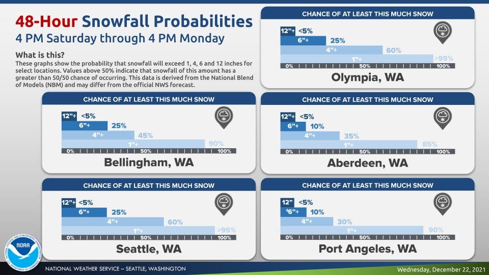
So far, forecasters are not expecting any one day will have major snowfall. But with the air so cold, any precipitation that falls is likely to be snow. The National Weather Service will continue to share daily updates as the weather approaches.
Bottom line for the snow forecast: It's going to be cold enough this weekend into next week. The real question is will there be precipiation. We'll probably see some snow, but timing, placement, amounts are still quite uncertain.
— NWS Seattle (@NWSSeattle) December 21, 2021
"This forecast will continue to evolve and confidence in the forecast likely won't be higher until the timing of the colder airmass becomes more clear," Kovacik said. "By Monday, however, [I] do think the area will be entrenched in the arctic airmass."
Get more local news delivered straight to your inbox. Sign up for free Patch newsletters and alerts.
