Weather
Cold Front Expected Saturday Night, Chance Of Lowland Snow
A persistently wet January continues the trend into February, bringing along a chance for snow as temperatures drop Saturday night.

SEATTLE, WA — High winds and heavy rains swept through Western Washington Friday night, prompting flood warnings along several rivers continuing into the weekend. A swift cooldown Saturday evening could allow for some lowland snowfall.
Flood warnings are now in effect for several rivers. Skokomish River at Potlach Skykomish River near Gold Bar Snoqualmie River near the Falls Snoqualmie River near Carnation Tolt River above Carnation View river forecasts & warnings at: https://t.co/YkxhAa1gQr #wawx
— NWS Seattle (@NWSSeattle) January 31, 2020
The National Weather Service said a series of wet weather systems was expected to move across the region through the weekend, continuing the risk for river flooding and landslides. A cold front will settle over Puget Sound Saturday evening, bringing at least a couple chances for lowland flurries. High temperatures are expected in the low-to-mid 40s, with overnight lows in the low 30s through early next week.
AM lows near freezing SUN-TUE, with low to mid 30s SUN, with upper 20s to mid 30s MON & TUE. Daytime highs thru this period in the 40s. Could be flurries or rain/snow mix SUN & TUE AMs, but accumulations are not expected. #WAwx pic.twitter.com/VEh6N2ERJA
— NWS Seattle (@NWSSeattle) February 1, 2020
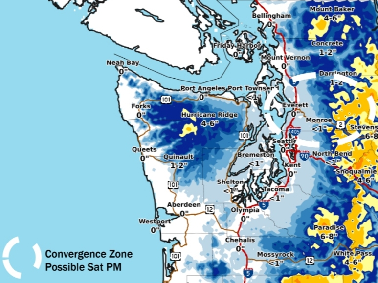
Should a convergence zone develop, 1 to 4 inches of accumulation could be possible Saturday night, particularly in north King County and Snohomish County. Outside the convergence zone, accumulations less than an inch are expected. Forecasters said a potential for a rain/snow mix will likely continue in the lowlands through Monday morning, with a fresh chance at snowflakes possible Tuesday.
Find out what's happening in Seattlefor free with the latest updates from Patch.
The latest round of weather follows a record-breaking month in the Seattle area, where January recorded 28 days of rain, tying two other years for first place.
The outcome was never really in doubt, but it’s official now: January 2020 earns a share of the first-place trophy by tying 1953 & 2006 for most rainy days in the month of January, at 28.
— Seattle Weather Blog (@KSeattleWeather) January 31, 2020
NWS Seattle said the highest winds should peak Friday evening, but gusts will continue along the Strait into Saturday morning. River flooding remains possible into Sunday, with the greatest impacts expected in King County and northward.
Find out what's happening in Seattlefor free with the latest updates from Patch.
Here is a map of expected max wind gusts this morning - windy in spots, but less than yesterday afternoon and evening. #wawx pic.twitter.com/BU9UVaaQIJ
— NWS Seattle (@NWSSeattle) February 1, 2020
Forecasters are tracking an increasing chance for another round of "significant rainfall" possible by mid-to-late next week.
We wish we could say we see a big break in the action next week but outside of a brief dry spell later Monday into early Tuesday, the saga continues. #wawx pic.twitter.com/dqXMcrcBfI
— NWS Seattle (@NWSSeattle) February 1, 2020
Get more local news delivered straight to your inbox. Sign up for free Patch newsletters and alerts.
