Weather
Hazy Skies, Red Flag Warning & Air Quality Impacts: WA Smoke Forecast
Heat, smoke and wind are on the docket starting Friday as summer rears its head once more. Here's what to expect.

SEATTLE — After a run of milder days to kick off September, summer will be back with a vengeance through the weekend, and Western Washington may be in for its first brush with wildfire smoke of the season.
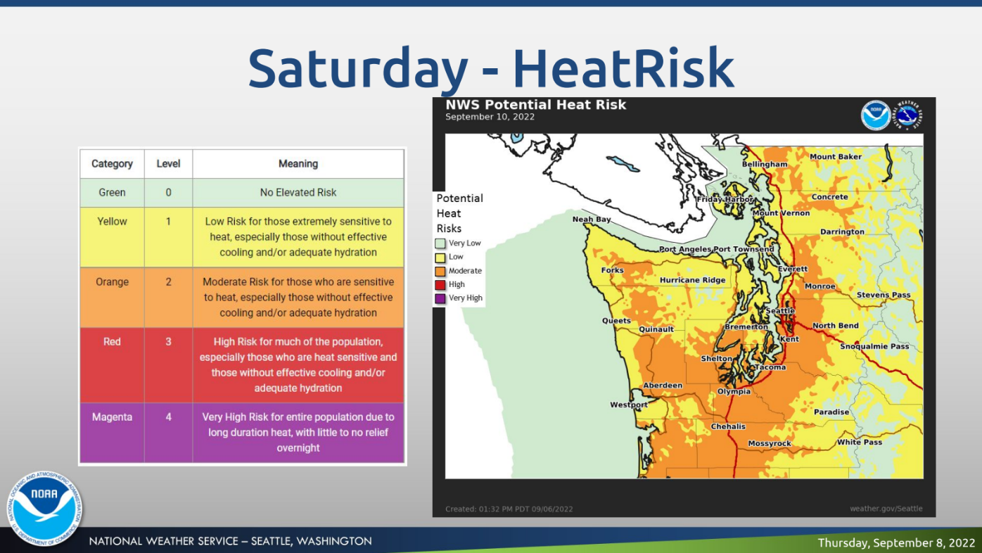
Forecasters expect high heat, wind and very low humidity will lend to a high risk for new fires igniting through Sunday. The National Weather Service has issued a red flag warning, which will take effect at noon Friday and remain in place through Saturday night.
At the same time, shifting winds are likely to filter in wildfire smoke from elsewhere, leading to hazy skies Friday around Seattle and potential air quality impacts on the ground.
Find out what's happening in Seattlefor free with the latest updates from Patch.
"With easterly winds Friday and Saturday additional smoke is expected to move into the area, along with warmer temperatures," NWS Seattle wrote Thursday. "Moreover, critical fire weather danger is expected with the hot and dry conditions. Make sure to obey local burn bans as fires will be able to start and spread easily."
High Fire Danger across much of western WA Friday through Sunday. Heed all fire restrictions. Use caution with fire triggers (grills, cars, campfires, ect). #wawx pic.twitter.com/PWn3nERP9K
— NWS Seattle (@NWSSeattle) September 7, 2022
According to the Washington Smoke Blog, multiple fires burning along the Cascades could send smoke toward Puget Sound. In Eastern Washington, several counties will be under an air quality alert through Monday, due to additional smoke coming from fires burning in Oregon and Idaho.
Find out what's happening in Seattlefor free with the latest updates from Patch.
In Western Washington, the Puget Sound Clean Air Agency said residents can expect some smoke Friday through the weekend, with air quality potentially declining to the "unhealthy for sensitive groups" range. The latest smoke forecasts predict "moderate" air quality in King, Pierce and Snohomish counties Friday through Monday.
We will likely start seeing wildfire smoke in the Cascades this afternoon due to heavy smoke in Eastern WA. We expect wildfire smoke to continue to spread Friday and into the weekend with levels that could be UNHEALTHY FOR SENSITIVE GROUPS. https://t.co/VhUWCQElpC for updates. pic.twitter.com/VR0MqLbSA8
— PS Clean Air Agency (@pscleanair) September 8, 2022
As for the heat, the National Weather Service expects temperatures will peak Saturday. The current forecast shows the Seattle-Tacoma International Airport reaching 90 degrees Saturday afternoon, which would be a rare feat for September and set a new all-time record for days at or above 90 degrees in a single year at 13.
Temperatures should level off a bit Sunday, dropping back into the low 80s, before tumbling into the mid-to-low 70s to kick off next week.
Residents can find updated air quality forecasts via the Puget Sound Clean Air Agency and check for daily updates on the Washington Smoke Blog. Live wildfire smoke conditions are available using the EPA's AirNow tool.
Get more local news delivered straight to your inbox. Sign up for free Patch newsletters and alerts.