Weather
'Juneuary' Persists, With Sunnier Days To Come: Puget Sound Forecast
After a very wet Thursday, showery conditions are in the forecast through the weekend, but some sunshine is due soon. Here's what to know.

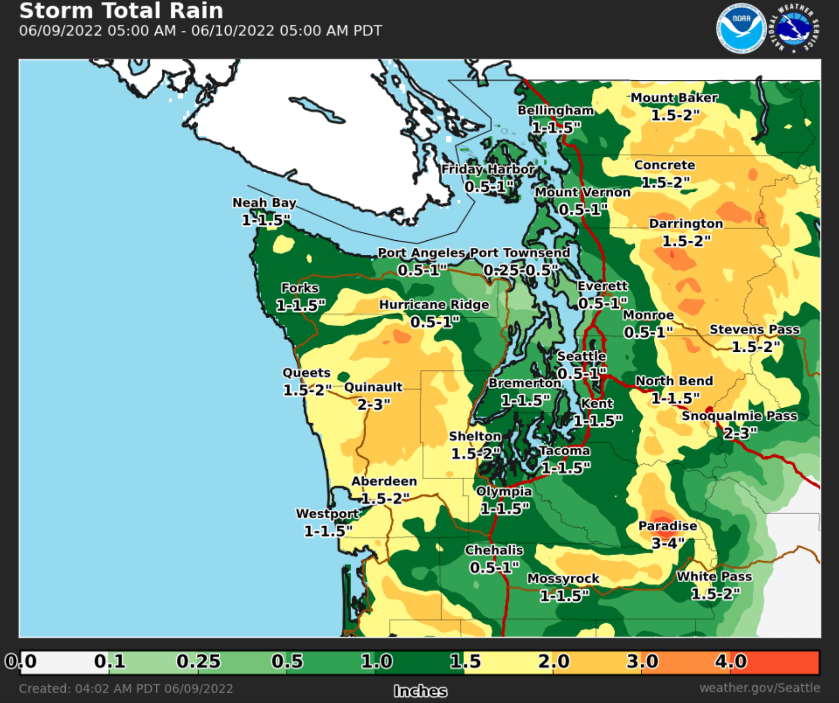
SEATTLE — Rain is in the forecast through most of the weekend, but the strongest showers should pass by Friday morning, and sunnier days should return by early next week, according to the National Weather Service. Puget Sound's latest run of wet weather is courtesy of a 2,000-mile moisture plume that will keep things soggy for the near future.
Heavier rain kicked up Thursday across Western Washington, and Seattle picked up more than a half-inch of rain before 4 p.m., putting the Emerald City on track to breaking a daily precipitation record. The National Weather Service said area rivers will rise through Friday, but most appear unlikely to reach their flood stages.
Forecasters expect the system will taper off into a more showery pattern Friday, before a second brings in a few lighter bouts of moisture through the weekend.
Find out what's happening in Seattlefor free with the latest updates from Patch.
Fortunately, things are looking brighter next week, with partly sunny skies appearing in the forecast Monday through Thursday and afternoon temperatures in the 60s.
"The [model] guidance suggests ridging will build at least somewhat into the area Tuesday and Wednesday for potentially drier, warming weather," NWS Seattle wrote Thursday. "Temperatures early next week into the low 60s, with mid to upper 60s for mid-week."
Find out what's happening in Seattlefor free with the latest updates from Patch.
Here is the five-day weather outlook for the Seattle area
- Friday: 67°/57° (Rain likely - 70%)
- Saturday: 66°/53° (Rain likely - 70%)
- Sunday: 62°/50° (Chance of rain - 40%)
- Monday: 62°/50° (Chance of rain, then partly sunny)
- Tuesday: 64°/50° (Slight chance of rain/partly sunny)
The drearier-than-normal spring has had some benefits for Washington, including a healthy snowpack in the mountains and improving drought conditions in Eastern Washington. However, despite logging the fourth-wettest April through May on record, some areas still remain under a drought declaration heading into prime wildfire season, including portions of Okanogan, Lincoln, Stevens and Spokane counties.
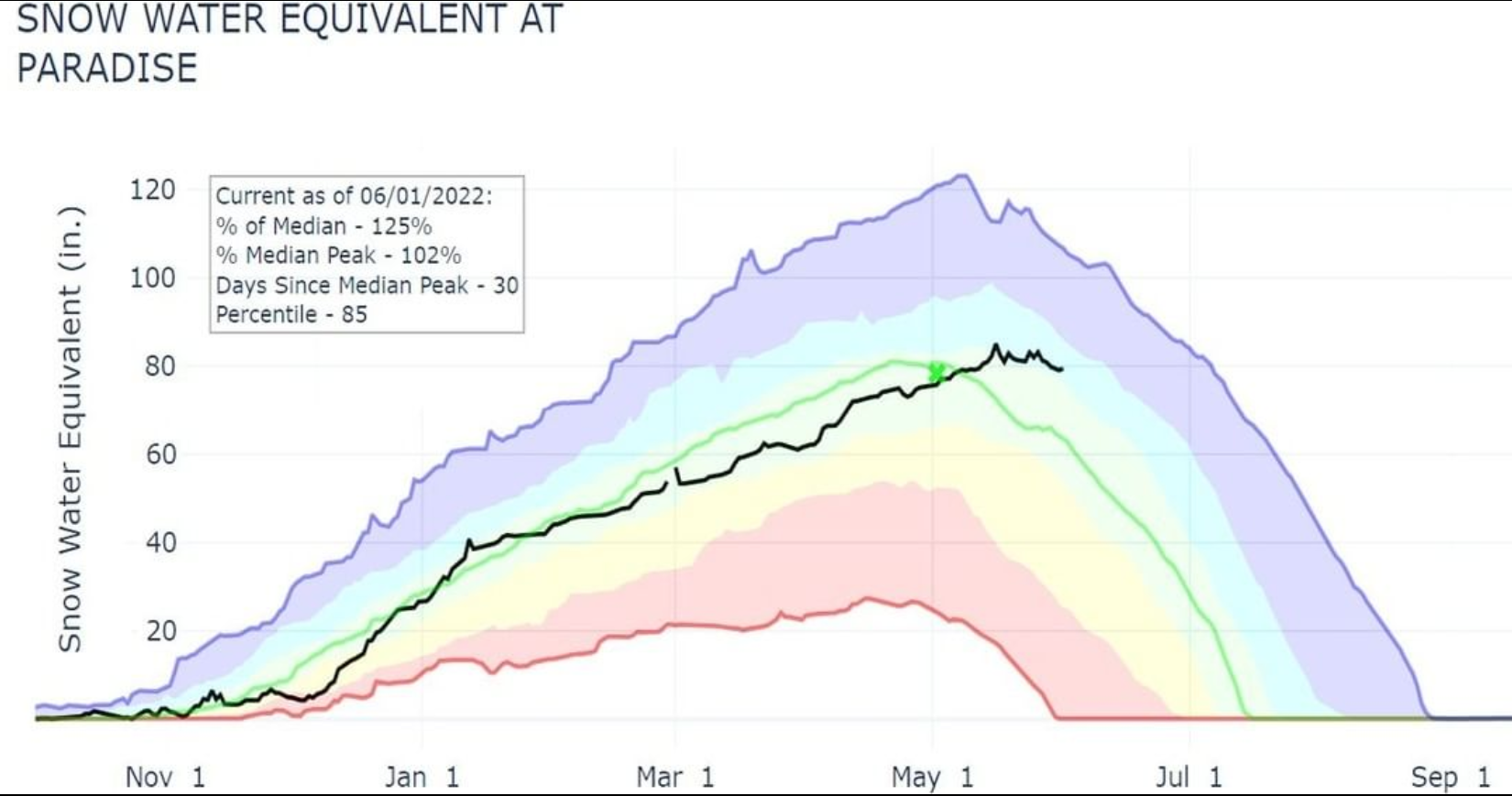
Up at Mount Rainier, temperatures at Camp Muir were just above freezing at noon Thursday, and the snowpack at Paradise is robust, which the National Park Service said is due largely to an "April comeback."
"A storm deposited 30" of snow at Paradise between April 3 and April 5," officials wrote on Instagram. "Another deposited 37" between April 8 and April 12. Slightly less ferocious storms later in April piled up an additional 30" of snowfall. Snow kept coming in May and by the first day of spring we had a quite robust snowpack height of 169.9" (124% of average)."
Get more local news delivered straight to your inbox. Sign up for free Patch newsletters and alerts.
