Weather
New Year's Snow: How Much To Expect Near You
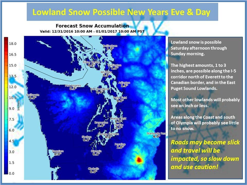
We've looked at all the forecasts. Find out how much snow might fall near you on New Year's Eve and into New Year's Day.

The consensus among many forecasters about snow on New Year's Eve and into New Year's Day is this: It'll snow, but probably not much.
But depending where you live you might see slightly more - or less - snow. In general, areas north of Seattle will see more snow, and areas around the south sound may see nothing at all.
Here are the latest New Year's Eve snow forecasts for the Puget Sound area:
Find out what's happening in Seattlefor free with the latest updates from Patch.
Seattle/Renton: Not much snow, maybe 1/2 to 1 inch, and it'll start after midnight - that's according to University of Washington meteorologist Cliff Mass.
Sammamish-Issaquah: The National Weather Service is predicting less than 1 inch, with a snow-rain mix beginning Saturday evening around dinner.
Find out what's happening in Seattlefor free with the latest updates from Patch.
Shoreline/Edmonds: Areas north of Seattle may see the most snow accumulation, according to the National Weather Service: between 1 and 3 inches. However, higher accumulations will be north of Everett, according to forecasts.
Bellevue/Eastside/Mercer Island: Some forecasts are calling for between 1 and 4 inches on the Eastside. But the National Weather Service is only calling for a 1/2 inch.
Enumclaw: One to 2 inches, according to the National Weather Service. The snow begins Saturday night and ends before 10 a.m. on Sunday.
Puyallup: Mostly rain before 10 a.m., then a rain-snow mix into early New Year's Day, according to the National Weather Service. Less than a 1/2 inch of accumulation.
Gig Harbor: Rain and snow showers intermittently through the night. No snow accumulation, according to the National Weather Service.
Bonney Lake-Sumner: Similar to many areas, less than a 1/2 inch of accumulation beginning around midnight.
Lakewood-University Place: Rain during the day with a little snow mixed in late at night, but no accumulation.
Image via National Weather Service
Get more local news delivered straight to your inbox. Sign up for free Patch newsletters and alerts.
