Weather
NWS: Settle In For Another Wet Week In Western Washington
After storms brought floodwaters to northern counties this weekend, another streak of wet weather is expected to begin Tuesday.

SEATTLE, WA — Another soggy forecast is in place for the week ahead, with the latest rainy weather system set to arrive Tuesday, and a good chance for wet weather through Friday. The National Weather Service said overnight lows near the freezing mark could allow for light lowland snow Tuesday morning, mainly on "grassy and elevated surfaces," before temperatures warm up in the afternoon.
[1030am] #SitRep: Light snow continues to fall this morning, mainly away from the water. The graphic shows the latest precipitation type reports compiled from mPING, social media, webcams, sensors, etc. Keep those reports coming today! Submit via: https://t.co/KtiJuv0AOP #wawx pic.twitter.com/guym2ISFh4
— NWS Seattle (@NWSSeattle) February 4, 2020
Forecasters said several periods of heavy rain were likely into the weekend, returning heightened risks for flooding and landslides. The latest series of storms arrive as northern counties are still dying out from weekend floods that prompted the closure of border crossings in Sumas and Lynden along with several school district closures in Whatcom County. The Associated Press reported three people were rescued from the Skykomish River Monday morning after getting trapped in their vehicles amid high water.
Additional weather systems poised to impact the region through the next 5 days. The main threats will be rising rivers, possible landslides, wet roads & gusty winds. Please stay tuned to the latest forecasts for additional information. #wawx pic.twitter.com/ZaxkeXfjdH
— NWS Seattle (@NWSSeattle) February 3, 2020
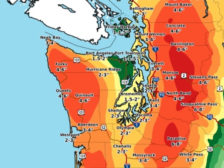
NWS Seattle said precipitation totals were forecast between 2 and 3 inches in Bellingham, Seattle and Tacoma between Tuesday and Friday afternoon. North Bend, Monroe and Darrington could see rainfall totals up to six inches over the same timeframe.
Find out what's happening in Seattlefor free with the latest updates from Patch.
MORE HEAVY RAIN From Tue PM-Thu PM, another 2-3 inches of rain is possible from downtown #Seattle northward. The mountains? Over 5 inches of rain possible. Not good for flooding. pic.twitter.com/EdUEY9S6Mm
— Seattle Weather Blog (@KSeattleWeather) February 3, 2020
According to forecasts, heavy mountain snow is another area of concern, especially Tuesday and Wednesday. Stevens Pass and Snoqualmie Pass were each expected to pick up another 12 to 18 inches of new accumulation by Wednesday morning.
Heavy snow in Cascades TUE nite thru WED morn could make for very difficult driving conditions. Snow levels start at 1000 ft TUE morn, then rise to 4000 ft by WED morn. Check latest pass conditions from @wsdot_passes at https://t.co/NfQjx5Jda0 before heading out! #wawx pic.twitter.com/ytE62c48sI
— NWS Seattle (@NWSSeattle) February 3, 2020
The National Weather Service said early forecasts allow for a short dry period in the region Friday morning before a new system moves in Friday night. More wet weather could be possible through the weekend.
Find out what's happening in Seattlefor free with the latest updates from Patch.
Monitor the latest river levels via the National Weather Service website.
Get more local news delivered straight to your inbox. Sign up for free Patch newsletters and alerts.
