Weather
Parade Of Storms Promises Several Days Of Rain For Puget Sound
Things are already wet in Western Washington, and they're about to get wetter. Here's what to expect as autumn slips into its rainy groove.


SEATTLE — Puget Sound will weather multiple storms over the next several days as the West Coast braces for a brush with another "bomb cyclone." According to the National Weather Service, the strongest in a "parade of frontal systems" is likely to impact Western Washington Sunday into Tuesday, bringing along the potential for high winds and rivers running at their highest levels of the season so far.
Who doesn't love a parade? Parade of frontal systems, that is. System #1 is now exiting the area. System #2 is just offshore...a fairly weak one that'll still make your Saturday damp. And #3, strongest of the bunch, is still in early stages of development south of the Aleutians. pic.twitter.com/ckgbydBg2l
— NWS Seattle (@NWSSeattle) October 22, 2021
Though Saturday's front is forecast to be the weakest in the group, Puget Sound will still see plenty of showers to kick off the weekend. The third system, arriving Sunday, is expected to be the strongest, but forecasters say there's some uncertainty remaining over the storm track. Either way, things promise to get pretty wet.
"Note that there is still uncertainty on the behavior of this system," NWS Seattle wrote Friday. "While models are all in agreement that the low will strengthen and approach the Washington coast, there is still no consensus agreement on what happens after that. Some [models] have it staying strong and heading towards [Western Washington], others have it weakening quickly as it approaches the shore, and others have it moving north as the previous systems have."
Find out what's happening in Seattlefor free with the latest updates from Patch.
What's behind the active weather ahead for us? A very strong jet stream over the Pacific. The jet is a fast flowing ribbon of air 30,000+ feet above the Earth's surface. The jet stream is a driving force behind rapidly developing storm systems. pic.twitter.com/pfG0zJ1YBF
— NWS Seattle (@NWSSeattle) October 21, 2021
Unlike portions of California and Oregon, where some forecasts predict up to 8 inches of rain, Washington's impacts are expected to be less extreme, landing between 1.5 and 2 inches around the Seattle metro through Tuesday. So far, forecasters do not expect most rivers will reach flood stage, but the marathon of rain is likely to leave them running pretty high.
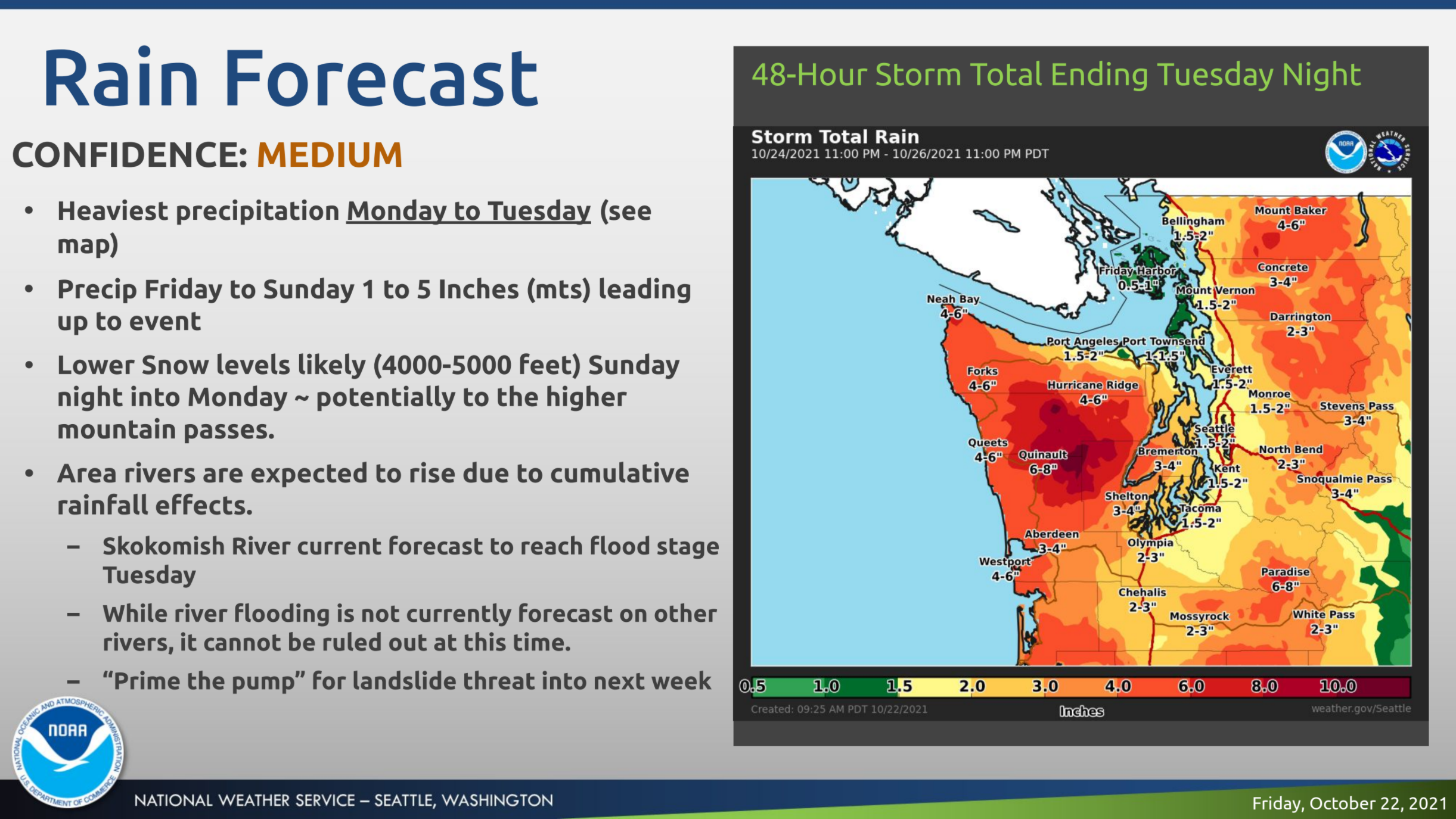
"While river flooding is not currently forecast for area rivers, it cannot be ruled out due to cumulative rainfall expected throughout the next week," NWS Seattle wrote. "Rivers, particularly the Skokomish, will need to continue to be closely monitored. While the amount of rainfall is not completely out of the ordinary for this area, the rivers have little time between systems to recover."
Find out what's happening in Seattlefor free with the latest updates from Patch.
Gusts are likely to pick up across the region with the third system, and there is a small chance that significant winds could make it inland. However, current forecasts show speeds peaking around 45 mph in Seattle.

Things are unlikely to dry out even after Tuesday, and forecasters see active weather continuing "for the foreseeable future," increasing the risk for flooding and landslides with each subsequent storm.
Here is the 5-day weather outlook for the Seattle area:
- Saturday: 51°/48° (Rain - 90%)
- Sunday: 60°/50° (Rain - 100%)
- Monday: 56°/48° (Rain - 90%)
- Tuesday: 54°/48° (Rain)
- Wednesday: 54°/46° (Rain)
Get more local news delivered straight to your inbox. Sign up for free Patch newsletters and alerts.
