Weather
Pleasant Summer Days Ahead As Rainless Streak Continues
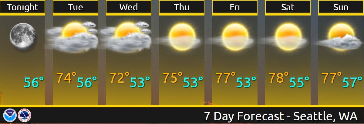
This week's forecast is stellar, with afternoon temperatures in the mid-70s, as Puget Sound sails into its sixth week without rain.


SEATTLE — With afternoon temperatures near 80, Monday was expected to be the warmest day of the week, setting the table for a pleasant run of sunny and moderate days in Puget Sound. Tuesday will start out pretty cloudy for most, with a slight chance for a little drizzle, before clearing for some afternoon sunshine in the low to mid-70s, forecasters said.
"A strong marine push [is] still on track to spread a solid marine layer across the lowlands of Western Washington Tuesday into Wednesday, along with cooler temperatures and a smattering of drizzle near the coast and locally over the interior," the National Weather Service wrote Monday. "Warmer and sunnier conditions still in the offing to round out the end of the week."
Temperatures should stick to the low 70s through Wednesday before notching up a bit through the end of the workweek. The weekend looks like it will be mostly clear, and just a touch warmer.
If the forecast holds, Puget Sound will record its sixth consecutive week without rain as a prolonged dry streak continues to create dangerous fire conditions across the West. More than a dozen major wildfires are burning across the Pacific Northwest.
As we reach the conclusion of week 5 without measurable rain in Seattle, here's a look back at how it happened from a satellite perspective. This is over 5 weeks of water vapor satellite imagery showing an upper level ridge dominating the Western U.S. #wawx pic.twitter.com/YJZ8Ano10o
— NWS Seattle (@NWSSeattle) July 19, 2021
A rather striking image. This is departure from normal in terms of precipitation across the lower 48 over the past 30 days. #wawx pic.twitter.com/ygGZ47PICI
— NWS Seattle (@NWSSeattle) July 19, 2021
As wildfires burn across the West, no air quality impacts are expected for Puget Sound
West of the Cascades, forecasters are not expecting air quality impacts in the lowlands this week, but other parts of the state are not so lucky.
"We're in a bit of a holding pattern to start the week," wrote Andrew Wineke on the Washington Smoke Blog. "That's good news if you're in western Washington, where onshore winds will continue to keep the smoke at bay and maintain air quality in the green zone. Less good if you're in north-central or southeast Washington, where large fires are producing a significant amount of smoke."
While there's a chance for some overhead haze developing, ground-level impacts are not expected for Puget Sound. The National Weather Service shared an image Monday afternoon showing pyrocumulus clouds from a wildfire burning in Okanogan County visible in Seattle.
Not the view we see from the office very often (or want to see). Pyrocumulus from the Cub Creek Fire some 110+ miles to our northeast. Hat tip to @kevinfreitas for alerting us. #wawx pic.twitter.com/lMROfa0G3b
— NWS Seattle (@NWSSeattle) July 19, 2021
Washingtonians can find live air quality information and forecasts via the state Department of Ecology.
Get more local news delivered straight to your inbox. Sign up for free Patch newsletters and alerts.
