Weather
Possible Thunderstorms New Year's Eve: Latest Washington Forecast
New Year's Eve is shaping up to be a blustery, wet affair for many according to the latest forecasts — and some areas may see lightning.

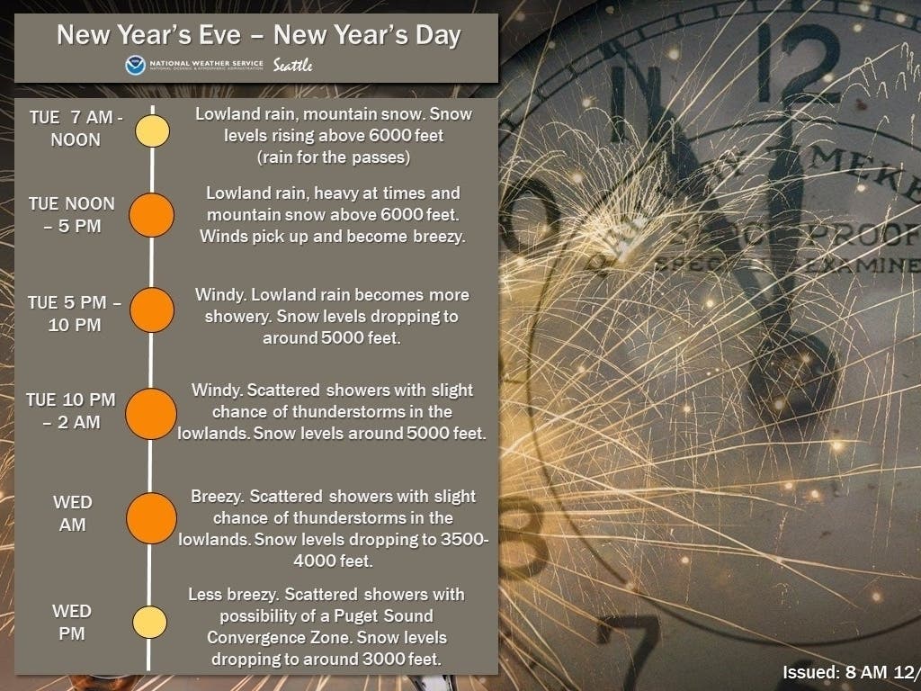
SEATTLE, WA — Many Western Washington towns may ring in the New Year on a soggy note, and some could see more than just fireworks lighting up the sky. The latest National Weather Service forecast shows the first in a series of wet systems moving into our area on New Year's Eve morning, with periods heavy rain, high winds and mountain snow expected by the afternoon.
Winds will pick up Tuesday morning, becoming windy for the rest of the day into Tuesday night. Plan ahead, especially if you still have holiday decorations outside or have outdoor plans! #wawx pic.twitter.com/2OEmcl9zBC
— NWS Seattle (@NWSSeattle) December 30, 2019
In Seattle, the fire department is monitoring weather conditions and could decide to cancel fireworks at the Space Needle if sustained winds hit 25 mph or gusts top 30 mph in the hours leading up to midnight. Seattle Fire said the safety precautions are in place through the department's Fire Prevention Division.
Meteorologists are also tracking a small chance of isolated thunderstorms in the lowlands Tuesday night and Wednesday morning — mainly between 10 p.m. and 2 a.m. — which could impact holiday fireworks celebrations in some areas. NWS Seattle said any lightning activity is not expected to be widespread.
Find out what's happening in Seattlefor free with the latest updates from Patch.
Heads up! There's a small chance of a few thunderstorms Tuesday evening into Wednesday morning as our first storm system blows through the area. We're not expecting widespread activity but it could impact outdoor celebrations! #wawx pic.twitter.com/w5pj8dodeZ
— NWS Seattle (@NWSSeattle) December 30, 2019
The timing of a second storm's arrival later in the week has shifted slightly. Precipitation is expected to turn to showers Wednesday, but a possible Convergence Zone Wednesday evening could mean heavier rain for some. A second system is forecast to move into the area Thursday evening, with a "burst" of rain and mountain snow continuing into Friday morning, ahead of a potential midday break. Gusty winds may return to the area Friday night.
The National Weather Service said river levels are expected to rise and a few may approach flood stage later in the week. Avalanche dangers and hazardous driving conditions are possible in the mountain passes as snow levels continue to flucuate. New snow accumulation at Stevens Pass is projected between 18 and 24 inches by Wednesday night, with 1 to 2 inches possible at Snoqualmie Pass.
Find out what's happening in Seattlefor free with the latest updates from Patch.
Rain totals from both systems are projected between 1.5 and 2 inches for Seattle, Tacoma and Everett.
Get more local news delivered straight to your inbox. Sign up for free Patch newsletters and alerts.
