Weather
Saturday Weather: Mountain Snow And Lowland Rains Continue
Low elevation snow is not expected Saturday, but a notable shift in temperatures Sunday will herald a new chapter of winter.

SEATTLE, WA — Heavy snow over the mountain passes will continue through at least Saturday night, but the lowlands are expected to stick to rain. Forecasts show afternoon highs similar to Friday, with temperatures in the mid-40s for Seattle, Tacoma, and Everett.
Latest: Lowland Snow Likely As Arctic Front Settles In Washington
According to the National Weather Service, the most widespread mountain snow should begin to taper off by Saturday night, but hazardous driving conditions will persist. New accumulation between Friday and Saturday night was forecast between 24 and 30 inches at Snoqualmie Pass and White Pass, with 18 to 24 inches at Stevens Pass. A Winter Storm Warning was extended through Monday morning for the Cascades.
Find out what's happening in Seattlefor free with the latest updates from Patch.
Planning to travel this weekend into next week? It may not be smooth sailing! We're expecting to continue in the mountain passes. Lowland possible by late weekend into next week. Check @wsdot for the latest information on road conditions! #wawx pic.twitter.com/SL5NuR2DW5
— NWS Seattle (@NWSSeattle) January 10, 2020
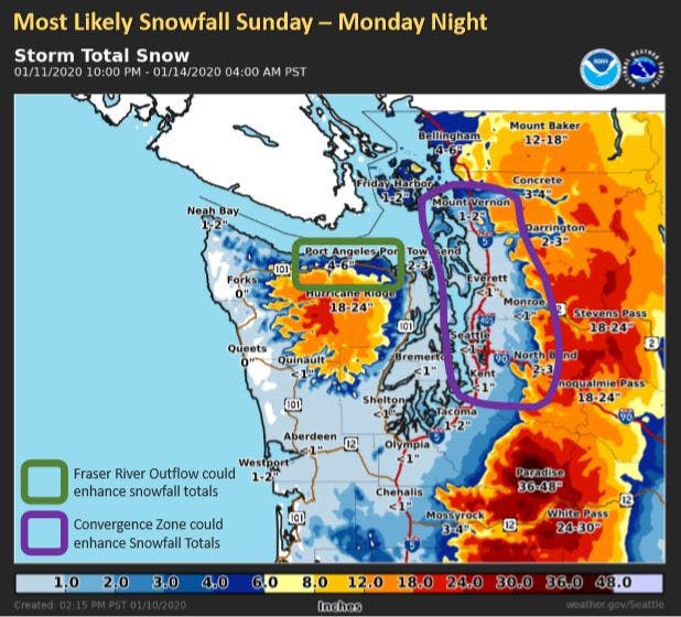
In the lowlands, there is a chance for a few breaks in the wet weather Saturday, but a potential Puget Sound Convergence Zone could prolong rain in some areas through Sunday morning.
SUNDAY NIGHT
Find out what's happening in Seattlefor free with the latest updates from Patch.
The real shift in the weather arrives Sunday evening, as an arctic front moves into our region, packing freezing temperatures and setting the table for a real possibility of lowland snow. Snow levels could fall to sea level, and early estimated snow totals were between 1 and 4 inches, especially in counties to the north or typical convergence zone areas.
Forecasters said confidence is growing that the weather will dry out between Monday night and Wednesday, but a hard freeze is likely. Some areas could stay below freezing until at least Thursday, and another period of widespread snow is possible Wednesday.
A look at the weekend and beyond - A pattern change will bring cooler weather to Western Washington and a chance for lowland snow Sunday night into Monday. A cold air mass will keep temperatures well below normal through next week. pic.twitter.com/H7x9s26BfH
— NWS Seattle (@NWSSeattle) January 11, 2020
Get more local news delivered straight to your inbox. Sign up for free Patch newsletters and alerts.
