Weather
A Chance For Flurries & More Rain Ahead: Puget Sound Forecast
A handful of communities could see a little snow in the air Wednesday morning, and Puget Sound can expect at least one more day of rain.


SEATTLE —Another round of moisture on tap Wednesday could bring a few lowland communities one more chance at a few snow flurries, as cool and showery weather continues across the region.
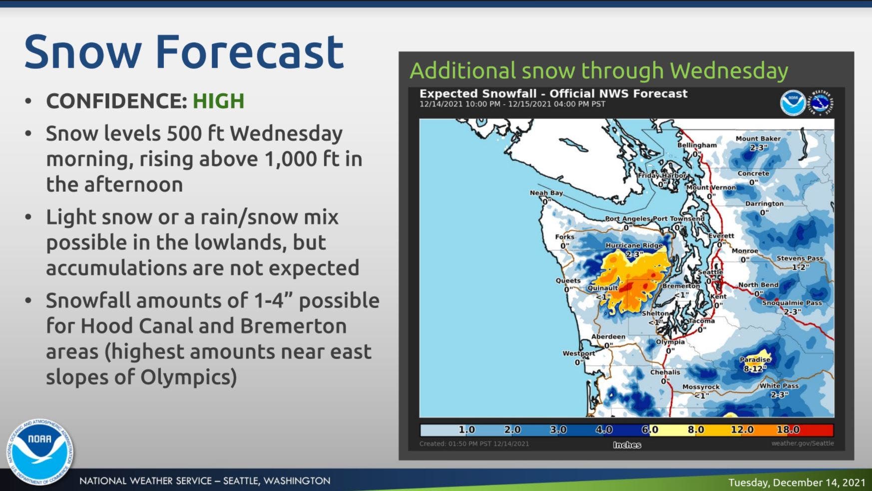
Forecasters expect snow levels Wednesday morning will hover at just a few hundred feet, and a rain/snow mix will be possible in much of the lowlands, particularly from Olympia southward and toward the coast. Seattle and Tacoma are most likely to see rain but could see a little snow mixed in if the cards fall just right.
While most lowland elevations saw rain Tuesday, videos shared on social media showed flakes falling along the coast and around Snoqualmie. Morning temperatures have kept chilly, too, prompting road crews to treat South Sound roads for ice and snow.
Find out what's happening in Seattlefor free with the latest updates from Patch.
A lucky, off duty forecaster sent us this video of it snowing at the beach! The snow and ocean mix is quite the sight! #wawx pic.twitter.com/3t3JPsCaBv
— NWS Seattle (@NWSSeattle) December 14, 2021
The Kitsap and Olympic peninsulas may see the most action Wednesday, where a winter weather advisory went into effect for areas around the Bremerton and the Hood Canal, with between 1 and 4 inches of snow possible.
Whether or not the rest of us see a little snow in the air on Wednesday, things are poised to be wet across Western Washington for at least another day before a break arrives late Thursday afternoon. The wintry temperatures are here to stay for the week, but overnight lows should stay above freezing for most.
Find out what's happening in Seattlefor free with the latest updates from Patch.
"High temps really only changing a few degrees up or down during the short term period, generally remaining within the lower 40s," the National Weather Service wrote Tuesday. "Overnight lows will remain cool but still remaining warm enough where any lowland snow, while not impossible, would be pretty difficult, only getting down into the mid to upper 30s."
Here is the five-day weather outlook for the Seattle area:
- Wednesday: 39°/37° (Rain/snow)
- Thursday: 42°/36° (Chance of rain)
- Friday: 43°/39° (PM rain likely)
- Saturday: 46°/38° (Rain)
- Sunday: 43°/36° (Chance of rain)
Forecasters expect the rain to taper off through Thursday and allow for relatively dry afternoons on Thursday and Friday before a stronger system brings more precipitation through Saturday. The lowlands can expect periods of heavy rain with that system, while the passes are looking at another round of heavy snow.
With the holiday week drawing near, forecasters are keeping a close eye on long-term models, but it's still too early to tell whether Puget Sound might see a white Christmas this year. While early indications are promising, the Seattle Weather Blog notes a lot can change between now and then.
If I had to bet, I’d bet against a White Xmas in Seattle, solely on the fact that our last one was only 4 years ago.
— Seattle Weather Blog (@KSeattleWeather) December 14, 2021
The National Weather Service will share more insight on Christmas weather expectations as the forecasts firm up next week.
Get more local news delivered straight to your inbox. Sign up for free Patch newsletters and alerts.
