Weather
Temperatures Tumble As Rain Tapers Off: Puget Sound Forecast
Puget Sound will have some time to catch its breath after Monday's storm, but a new chill is in the air. Here's what's ahead this week.


SEATTLE — After a double-dose of rain and wind courtesy of the Pineapple Express, Western Washington has finally earned itself a little time to dry off and chill out. Temperatures dropped nearly 10 degrees in 20 minutes as the cold front arrived Monday afternoon.
When the front passed through Everett in the last hour, the temperature fell 9 degrees in 20 minutes. Next stop: Seattle metro. #wawx
— NWS Seattle (@NWSSeattle) November 15, 2021
Things could feel downright wintry Tuesday and Wednesday morning, especially compared to the unseasonably warm temperatures of recent days. On Monday, Seattle tied its record high for Nov. 15, hitting 62 degrees at Sea-Tac Airport by the end of the morning commute. By contrast, Tuesday looks unlikely to crack 50 degrees even by the afternoon.
The abrupt drop in temperatures also brought snow levels down considerably, and the mountain passes are looking at quite a bit of fresh powder into Tuesday.
Find out what's happening in Seattlefor free with the latest updates from Patch.
"The heaviest snow is expected for Stevens Pass with the convergence zone setting up in that area," NWS Seattle wrote Monday afternoon. "Amounts of 12 - 18" will be possible through Tuesday at Stevens Pass, with lighter amounts at Snoqualmie Pass of 5 - 9". Prepare for winter conditions over the pass through Tuesday."
Snow on Hwy 2 Stevens pass, WA has started. More to come likely worsening road conditions this evening and overnight in that area on Hwy 2. By Tuesday morning, 6 to 9 inches could fall. If it's concentrated over the pass then possibly up to 15 inches. #wawx #winter pic.twitter.com/5F1ZDDoVTm
— NWS Spokane (@NWSSpokane) November 16, 2021
For the lowlands, Tuesday night may be the chilliest in a while, with overnight temperatures forecast at 34 degrees in Seattle and dipping just below freezing around Tacoma and Olympia.
Find out what's happening in Seattlefor free with the latest updates from Patch.

While it will be cold, sunshine is in the forecast through at least Wednesday, before rain showers return to cap off the week.
Flood watch ends Tuesday afternoon, and a recap of Monday's storm
Though the bulk of the rough weather has passed, a flood watch remains in effect until 4 p.m. Tuesday for portions of Western Washington, including King, Snohomish, Clallam, Jefferson and Grays Harbor counties.
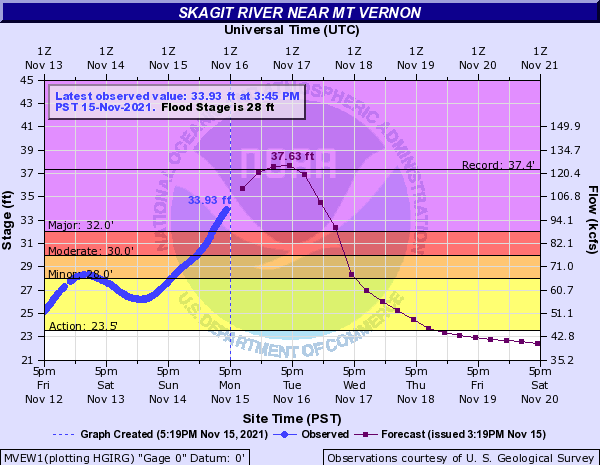
The main areas of concern were well north of Seattle, and forecasters expected the Skagit River at Mount Vernon would crest at a record high Tuesday afternoon.
Wind speeds started to decline Monday afternoon and will continue to ease Tuesday, after a day that brought gusts above 40 mph across the region.
Here are a few of the highest gusts recorded Monday by the National Weather Service:
- Mount Baker: 93 mph
- Crystal Mountain: 92 mph
- Whidbey Island NAS: 63 mph
- Snoqualmie Pass: 61 mph
- Sea-Tac Airport: 58 mph
- Olympia: 55 mph
- Bellingham: 49 mph
- Puyallup: 48 mph
- Bellevue: 47 mph
- Renton: 45 mph
Today’s peak gust of 58 mph was the 3rd-highest wind gust for Seattle (Sea-Tac) since the infamous Hanukkah Eve windstorm of 2006 (69 mph). Since then, the only days windier then today have been Jan. 6, 2019 (60 mph) and Dec. 17, 2012 (59 mph).
— Seattle Weather Blog (@KSeattleWeather) November 15, 2021
Up in Whatcom County, a mudslide blocked Interstate 5 near Bellingham, and several vehicles were hit. Washington State Patrol said the roadway would remain closed into Tuesday, due to flooding and lingering slide concerns.
Both north and south I-5 in Bellingham closed overnight for flooding and active slides. https://t.co/lCE8EsoUJU pic.twitter.com/xOJzEywIns
— Trooper Rocky Oliphant (@wspd7pio) November 16, 2021
Another scary scene developed over the Deception Pass Bridge, where wind gusts tipped a semi-truck onto the railing.
HAPPENING NOW: SR 20 fully blocked EB & WB from Cornet Bay Rd (MP 41) to Rosario Rd (MP 43) due to semitruck that has tipped onto the railing. Crews are onscene. Expect delays. (Photo: @eljavii10) https://t.co/GtVX6fmA3l
— WSDOT North (@wsdot_north) November 15, 2021
Related coverage:
Get more local news delivered straight to your inbox. Sign up for free Patch newsletters and alerts.
