Weather
Warm, Dry Summer Expected; NWS Releases 2020 Fire Season Outlook
Long-term forecasts predict a warmer, drier trend in spring will continue through the summer months in Washington.

SEATTLE, WA — The National Oceanic and Atmospheric Administration's long-term outlook shows a higher likelihood for above-normal temperatures and below-normal precipitation in Washington through the summer months ahead.
According to the Climate Prediction Center, May, June and July have good odds for warmer temperatures throughout the Pacific Northwest, and much of the United States. Longer-term projections indicate that pattern could continue through September.
Washington, Oregon and most of Idaho also have favorable odds for a drier-than-usual summer.
Find out what's happening in Seattlefor free with the latest updates from Patch.

Early look at the 2020 fire season in Washington
Find out what's happening in Seattlefor free with the latest updates from Patch.
The National Weather Service released its first look at the 2020 fire season this week and said a warmer, drier spring could potentially lead to an earlier start to fire season. However, lower precipitation expected through the summer months will also limit the potential for lightning strikes.
Forecasters consider several pieces of data to predict the upcoming fire season's behavior, including how they have shaped up in previous years with similar conditions in place. NWS Seattle said June is typically the key month they look at to get a firm idea on what to expect for the fire season, which typically runs from July to September.
Long-term predictions also leave plenty of room for change.
In 2019, we saw largely warm and dry conditions in March, May and June, and the long-range forecast at the time expected those to continue through the season, much like this year. Instead, the National Weather Service said, near-normal temperatures returned and rainfall increased in July and August, then fall-like conditions arrived early in September.
As a result, our fire season was fairly mild, with approximately 249,474 acres burned across Washington. But, over the last 10 years, five of them have landed in the top 10 worst fire seasons on record, with more than a million acres burning in both 2014 and 2015.
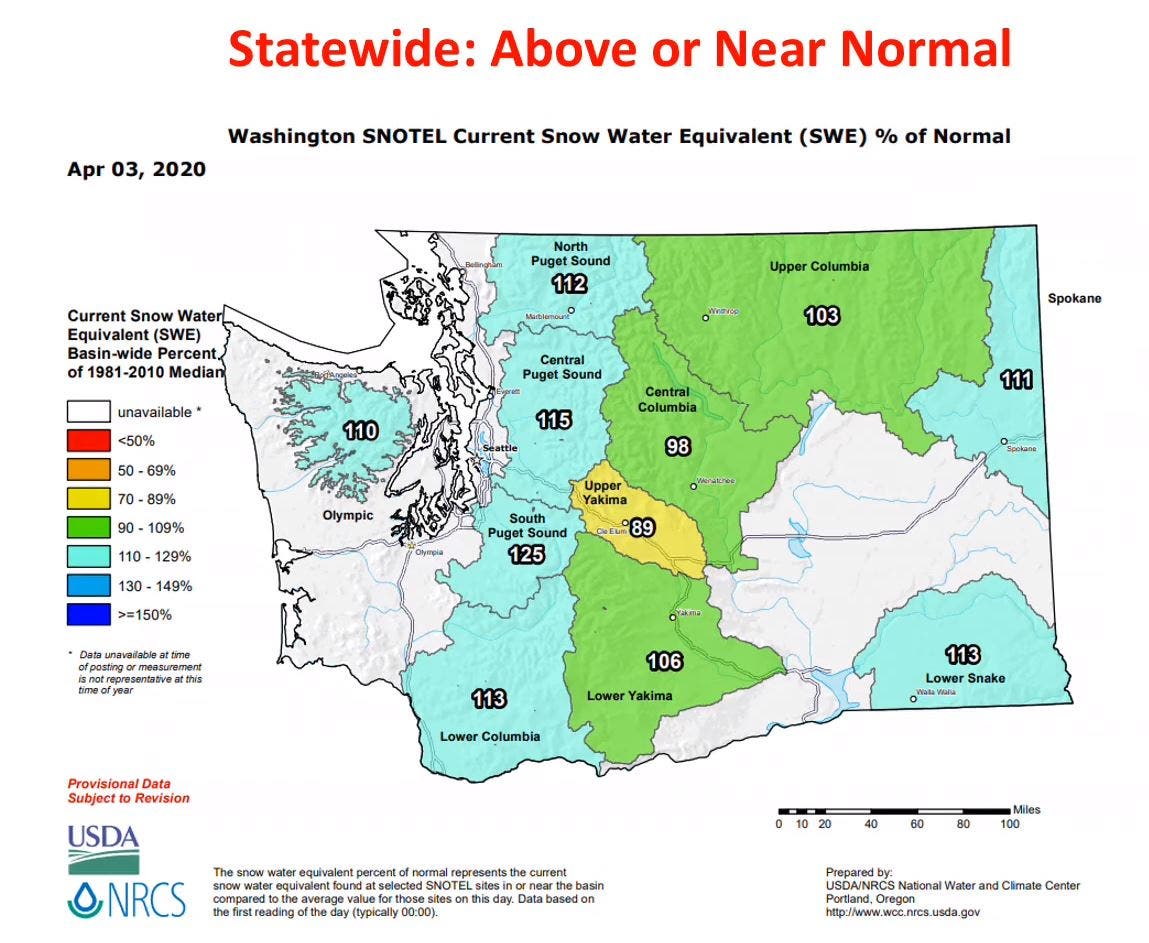
Another factor that can play a small role in the severity of our fire season is the snowpack. The NWS said this winter got off to a slow start, but wet conditions in January and February helped us rebound close to or above normal levels throughout much of the state.
According to the U.S. Drought Monitor, roughly two-thirds of Washington is in good shape, especially on the state's western and eastern borders. Central Washington, however, remains abnormally dry and has a few pockets with severe drought conditions.

Forecasters said it is too early to predict how long this year's fire season might last.
Get more local news delivered straight to your inbox. Sign up for free Patch newsletters and alerts.