Weather
Washington Weather Forecast: Lowland Rain, Mountain Snow Return
After a break in the wet weather, forecasters are tracking several weather systems moving into the region, continuing into next weekend.

SEATTLE — After a brisk, mostly dry weekend, Western Washington will welcome back the rain, along with some mountain snow, as several weather systems move into the region in the coming days.
According to the latest forecasts, the recent bout of chilly and dry weather will give way to slightly warmer and wetter conditions as clouds return to Puget Sound.
Planning out your week? Here's a look ahead! Several weather systems will move through the area starting Monday PM & continuing into next weekend. Those with travel plans over the Cascades should keep an eye on the forecast as snow levels will be below the passes! #wawx pic.twitter.com/aHtXWbVIhc
— NWS Seattle (@NWSSeattle) November 8, 2020
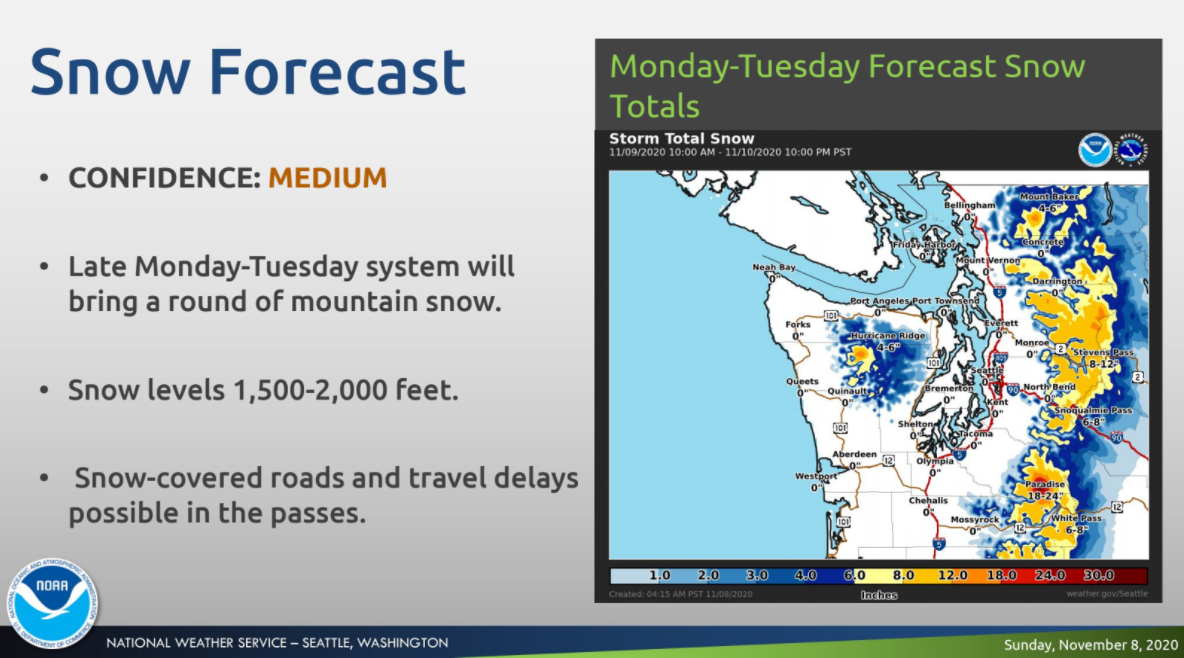
Monday is poised to start fairly frigid, with temperatures in the high 20s to low 30s for most, ahead of the next weather system. Beginning Monday night, forecasters expect a new pattern will bring rain to the lowlands while snow levels drop as low as 1,500 feet.
Find out what's happening in Seattlefor free with the latest updates from Patch.
Showers are likely to continue Tuesday, with some isolated thunderstorms near the coast and more snow possible in the Cascades. Wednesday should offer a brief break in the precipitation before a new system moves in, bringing more rain and high elevation snow, ahead of a stronger system possible Friday and Saturday.
If you've enjoyed the dry weather today, enjoy it while you can! A weather system will bring lowland rain and some mountain snow starting Monday afternoon through Tuesday. Here's a look at forecast amounts for each! #wawx pic.twitter.com/OeJZNtqgHB
— NWS Seattle (@NWSSeattle) November 9, 2020
Here is the 5-day outlook in the Seattle region:
Find out what's happening in Seattlefor free with the latest updates from Patch.
Monday: 45°/42° (Clouds, then a chance of rain)
Tuesday: 47°/38° (Chance of rain)
Wednesday: 48°/40° (Mostly cloudy)
Thursday: 49°/43° (Rain likely)
Friday: 49°42° (Rain likely)
After a mid-week break, forecasters expect a new frontal system will approach, packed with breezy conditions, heavy rain and another round of mountain snow continuing into next weekend. Details on the amount of the late-week storm are still being refined and will be shared in the coming days.
Get more local news delivered straight to your inbox. Sign up for free Patch newsletters and alerts.
