Community Corner
New Slide Near Oso Will Keep SR 530 Closed
The state Department of Transportation is monitoring a slow moving landslide near Oso.

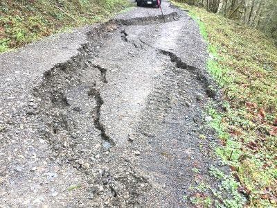
OSO, WA - State transportation officials will keep a stretch of SR 530 near Oso closed until at least Monday as they monitor a slow-moving landslide there. The slide is about 1-1/2 miles southwest of where the 2014 Oso slide occurred. A hillside above SR 530 is showing signs of movement, and other roads in the area have split in half.
"The slow moving slide was discovered on Monday, April 3. On Friday evening, April 7, DNR crews observed additional ground movement in the area, likely due to heavy rains, and asked WSDOT to close SR 530 as a precaution. The Oso Fire Department issued a voluntary evacuation for about a dozen homes near the slide area," WSDOT wrote in a blog post published Saturday.
In the meantime, there's a detour around the area using SR 20 and I-5. The road is closed between Oso Loop Road (milepost 34) and C-Post Road (milepost 38) as a safety precaution, according to WSDOT.
Find out what's happening in Woodinvillefor free with the latest updates from Patch.
Forty-three people died in the 2014 Oso landslide, where a section of hillside collapsed, spilling into the Stillaguamish River. The slide ended up covering a one-square mile area; it was the deadliest single landslide in U.S. history not related to an earthquake or volcano.
Image via WSDOT
Find out what's happening in Woodinvillefor free with the latest updates from Patch.
Get more local news delivered straight to your inbox. Sign up for free Patch newsletters and alerts.