Weather
Potential ‘Super El Niño’ Coming Faster Than Expected: What It Means For WI
NOAA says El Niño is likely to develop soon, but what that means for Wisconsin is still far from certain.

WISCONSIN — A potentially strong El Niño could be on the way, raising the possibility of a milder winter in Wisconsin.
But don’t count on a snow-free winter just yet.
The National Oceanic and Atmospheric Administration’s Climate Prediction Center said in its latest update that El Niño is likely to develop soon, with an 82 percent chance of emerging between May and July 2026.
Find out what's happening in Across Wisconsinfor free with the latest updates from Patch.
Forecasters said there is also a 96 percent chance that El Niño conditions will continue through the winter of 2026-27.
El Niño happens when sea surface temperatures in the central and eastern tropical Pacific Ocean become warmer than normal, disrupting weather patterns around the globe, according to NOAA.
Find out what's happening in Across Wisconsinfor free with the latest updates from Patch.
In the United States, El Niño often shifts the Pacific jet stream south. That can make many northern parts of the country warmer and drier than usual during winter, according to NOAA.
Still, forecasters are urging caution.
NOAA said there is "substantial uncertainty" about how strong the developing El Niño will become. No strength category currently has more than a 37 percent chance, according to the Climate Prediction Center.
And even a strong El Niño does not guarantee a mild or low-snow winter in Wisconsin.
What El Niño Usually Means In Wisconsin
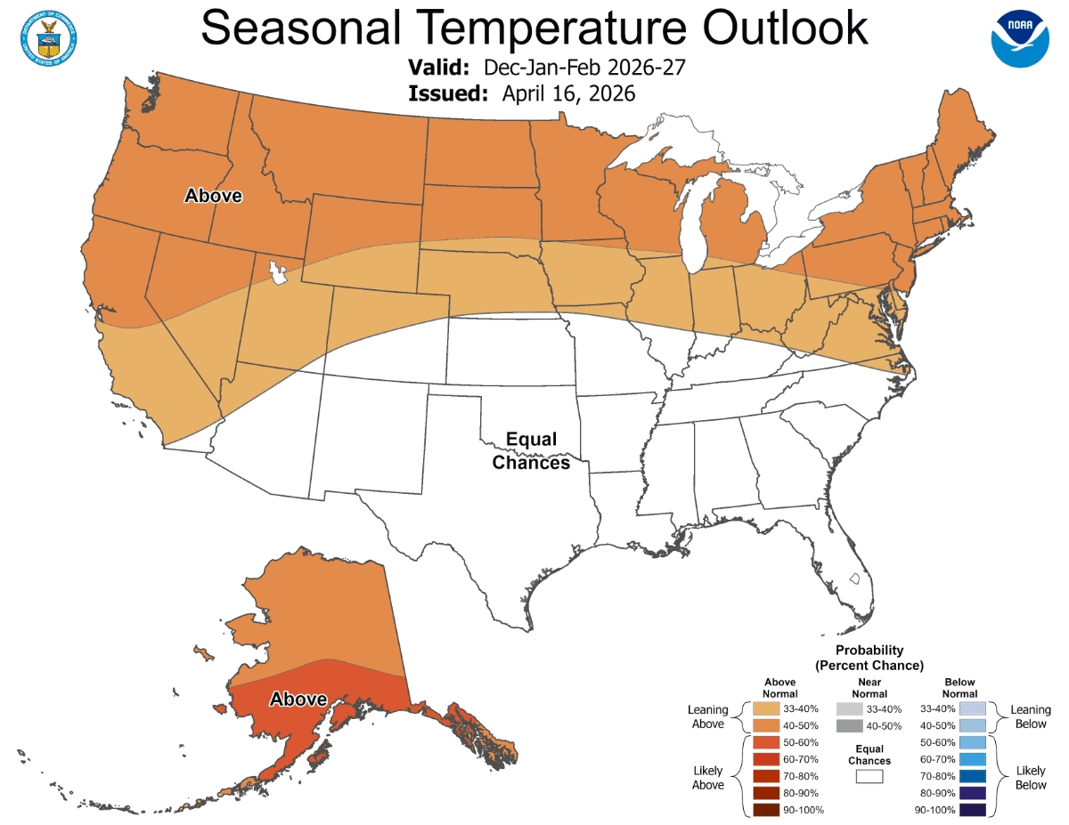
Wisconsin is one of the northern states where El Niño can tilt the odds toward a warmer winter, according to NOAA.
The National Weather Service office in La Crosse reviewed the 10 strongest El Niño events since 1900 and found that average winter temperatures were either near or above normal across the Upper Midwest and Great Lakes region.
Half of those winters were among the 10 warmest winters on record in Wisconsin, according to the National Weather Service.
But snow and precipitation are much harder to predict.
The National Weather Service office in Milwaukee says there is no strong correlation between El Niño and winter precipitation in southern Wisconsin.
During the past seven strong El Niño winters, precipitation in southern Wisconsin ranged from 2 inches below average to 2.5 inches above average, according to the weather service.
Snowfall has leaned lower during strong El Niño winters, but not always.
Milwaukee averages about 37 inches of snow during the winter season, while Madison averages about 32 inches, according to the National Weather Service.
Of the past seven strong El Niño winters, snowfall was near to below average in six of them. But one strong El Niño winter brought roughly 18 inches above-average snowfall, according to the National Weather Service.
What Wisconsinites Should Watch
For now, the safest takeaway is this:
El Niño can tilt the odds toward a warmer winter in Wisconsin, but it does not write the forecast months in advance.
A strong El Niño could increase the chances of:
- A milder-than-normal winter
- Fewer stretches of extreme cold
- Less snow than usual in parts of Wisconsin
- More variability from storm to storm
But Wisconsin can still see major snowstorms, bitter cold snaps and messy winter travel during El Niño years.
That is especially true because snowfall varies widely across the state. NOAA says annual snowfall ranges from about 30 inches in southern Wisconsin to more than 100 inches along the Gogebic Range near Lake Superior.
NOAA is expected to keep updating its El Niño outlook in the months ahead. The clearer picture for Wisconsin will come later this year, when federal forecasters release their winter outlooks.
Get more local news delivered straight to your inbox. Sign up for free Patch newsletters and alerts.