Weather
Hail, Damaging Winds Possible In Milwaukee Friday: WI Weather
Milwaukee residents should expect scattered thunderstorms throughout the daytime hours, with more severe weather possible in the evening.


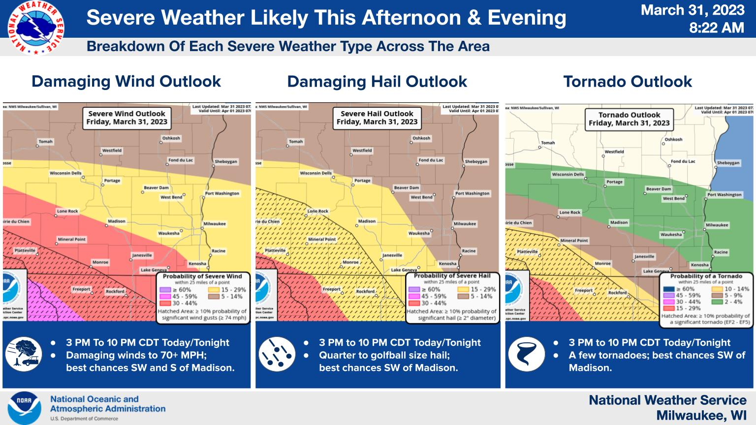
MILWAUKEE — Major spring storms could bring severe weather to Wisconsin Friday, including golf ball size hail and damaging winds in the Milwaukee metro.
Meanwhile, there is a chance of tornadoes in the Madison area.
Friday morning and early afternoon will feature scattered thunderstorms in Milwaukee, with threats of cloud-to-ground lightning and some hail possible.
Find out what's happening in Across Wisconsinfor free with the latest updates from Patch.
There will be even more chances for severe weather in the evening across the state:

Here's the specific NWS forecast from the Milwaukee Mitchell International Airport:
Find out what's happening in Across Wisconsinfor free with the latest updates from Patch.
Friday: A chance of showers and thunderstorms, then showers likely and possibly a thunderstorm after 4pm. Patchy fog after 3pm. Otherwise, cloudy, with a high near 60. South wind 10 to 15 mph becoming east in the afternoon. Chance of precipitation is 60%. New rainfall amounts between a tenth and quarter of an inch, except higher amounts possible in thunderstorms.
Friday Night: Rain showers before 5am, then a chance of rain and snow showers. Some thunder is also possible. Patchy fog before 10pm. Low around 35. Breezy, with an east wind 10 to 15 mph becoming southwest 15 to 20 mph after midnight. Winds could gust as high as 35 mph. Chance of precipitation is 100%. Little or no snow accumulation expected.
Saturday: A chance of rain and snow before 7am, then snow between 7am and 1pm. High near 39. Windy, with a west wind 15 to 20 mph becoming north 20 to 25 mph in the morning. Winds could gust as high as 40 mph. Chance of precipitation is 80%. New snow accumulation of less than a half inch possible.
Saturday Night: Mostly clear, with a low around 27. North wind 5 to 10 mph becoming southeast after midnight.
Sunday: Partly sunny, with a high near 52. Breezy, with a south wind 10 to 20 mph, with gusts as high as 25 mph.
Sunday Night: Partly cloudy, with a low around 39. Breezy, with a south wind 15 to 20 mph, with gusts as high as 30 mph.
Monday: A 20 percent chance of showers after 1pm. Partly sunny, with a high near 54. West wind around 10 mph.
Monday Night: Showers likely, mainly before 1am. Mostly cloudy, with a low around 37. Northeast wind 10 to 15 mph. Chance of precipitation is 60%. New precipitation amounts of less than a tenth of an inch possible.
Tuesday: A chance of showers, then showers and possibly a thunderstorm after 1pm. High near 55. Breezy. Chance of precipitation is 80%.
Tuesday Night: Showers and possibly a thunderstorm before 1am, then showers likely. Low around 41. Breezy. Chance of precipitation is 90%.
Wednesday: A 30 percent chance of showers. Mostly sunny, with a high near 57. Windy.
Wednesday Night: Partly cloudy, with a low around 28. Windy.
Thursday: Sunny, with a high near 45. Breezy.
Get more local news delivered straight to your inbox. Sign up for free Patch newsletters and alerts.