Weather
Flood Watch, High Swim Risk In Effect As Heavy Rain Targets South Central Wisconsin
One to 3 inches of rain is forecast tonight into Saturday, with flash flooding possible.


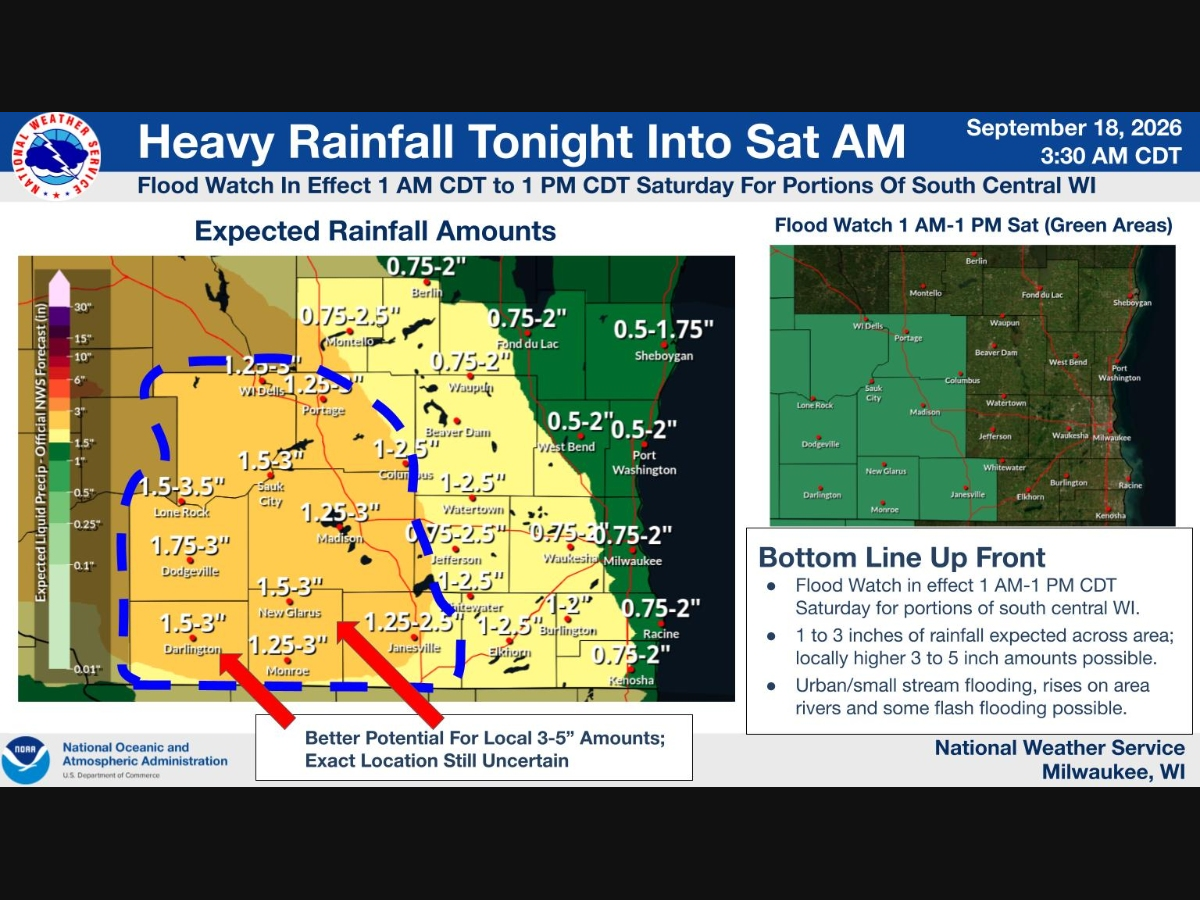
A Flood Watch is in effect from 1 a.m. to 1 p.m. CDT Saturday for portions of south-central Wisconsin, according to the National Weather Service.
Widespread heavy rainfall of 1 to 3 inches is forecast from tonight through Saturday morning across southern Wisconsin, with rainfall rates up to 1 inch per hour possible in storms.
Locally higher amounts are possible, especially where multiple rounds of storms track over the same areas, with the better chances for that falling within the Flood Watch area, though forecasters caution there is some uncertainty in exactly where the heaviest rainfall will land.
Find out what's happening in Milwaukeefor free with the latest updates from Patch.
The heaviest rain is expected to fall overnight tonight into Saturday morning.
Officials warn of a risk for urban and small stream flooding, rises on area rivers, and some flash flooding, especially within the Flood Watch area. Additional rounds of showers and storms may develop Saturday afternoon through Sunday, especially along and south of Highway 18 and Interstate 94, which could bring further flooding.
Find out what's happening in Milwaukeefor free with the latest updates from Patch.
The National Weather Service is urging residents to stay updated on the forecast, prepare for heavy rain, and remember to "turn around, don't drown" if they encounter flooded roads.
Separately, a High Swim Risk is in effect today for Lake Michigan beaches in Milwaukee, Racine, and Kenosha Counties. Persistent east winds, high waves, and dangerous water currents are expected, and officials are urging swimmers to stay out of the water.
Check out the full NWS forecast for Milwaukee below:
Today: Isolated showers before 3pm, then isolated showers after 5pm. Mostly cloudy, with a high near 68. East wind around 10 mph. Chance of precipitation is 20%.
Tonight: Showers likely, then showers and possibly a thunderstorm after 1am. Low around 59. Northeast wind 10 to 15 mph. Chance of precipitation is 100%. New rainfall amounts between three quarters and one inch possible.
Saturday: Showers and possibly a thunderstorm before noon, then a chance of showers and thunderstorms between noon and 3pm, then showers likely and possibly a thunderstorm after 3pm. High near 68. Southeast wind 10 to 15 mph, with gusts as high as 25 mph. Chance of precipitation is 90%. New rainfall amounts between three quarters and one inch possible.
Saturday Night: Showers likely and possibly a thunderstorm. Cloudy, with a low around 55. Northeast wind 5 to 10 mph. Chance of precipitation is 60%. New precipitation amounts between three quarters and one inch possible.
Sunday: A 50 percent chance of showers. Mostly cloudy, with a high near 66. Breezy, with a northeast wind 10 to 20 mph, with gusts as high as 30 mph.
Sunday Night: A 30 percent chance of showers after 1am. Mostly cloudy, with a low around 50. East wind 10 to 15 mph, with gusts as high as 25 mph.
Monday: A 40 percent chance of showers. Mostly cloudy, with a high near 63. Breezy, with an east wind 15 to 20 mph, with gusts as high as 30 mph.
Monday Night: A 20 percent chance of showers. Mostly cloudy, with a low around 50. Northeast wind 10 to 15 mph, with gusts as high as 25 mph.
Tuesday: A 20 percent chance of showers. Partly sunny, with a high near 62.
Tuesday Night: Mostly cloudy, with a low around 50.
Wednesday: Partly sunny, with a high near 64.
Wednesday Night: Mostly cloudy, with a low around 50.
Thursday: Partly sunny, with a high near 67.
Get more local news delivered straight to your inbox. Sign up for free Patch newsletters and alerts.