Weather
Heavy Rain, Flooding, Cold Front Thursday Night: NWS
Our area has already seen between two to six inches of rain since Monday night, with much of this rain coming in the last 24 hours.


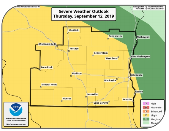
MILWAUKEE, WI — The National Weather Service says that rain showers and thunderstorms will produce heavy rainfall Thursday that may lead to flooding today and tonight.
Southeastern Wisconsin has already seen between two to six inches of rain since Monday night, with much of this rain coming in the last 24 hours. There is increasing concern for flooding as multiple rounds of rainfall the past few days have resulted in saturated soils. A Flash Flood Watch has been issued for all of southern Wisconsin.
The heaviest rainfall will be focused west of I-90. Isolated rainfall amounts upwards of two inches are possible across the entire area. The National Weather Service says thunderstorms will enter Southeastern Wisconsin starting around 6 p.m., with the wet weather hanging around until at least 7 a.m. Friday.
Find out what's happening in Milwaukeefor free with the latest updates from Patch.
Showers and thunderstorms will slowly move north across the area Thursday ahead of an approaching system. Moderate to occasional heavy rain is possible today. Another round of showers and storms are expected tonight as a cold front sweeps across the area.
Strong to severe storms are possible later tonight with the cold front.
Find out what's happening in Milwaukeefor free with the latest updates from Patch.
At A Glance
Hazards: An additional 1 to 3 inches of rain tonight may lead to flooding. Severe
thunderstorms with strong winds are the main threat especially this afternoon and
evening.
Areas Impacted: All of southern Wisconsin.
Timing And Duration: A few Scattered thunderstorms are expected through this
afternoon. A line of strong severe thunderstorms is expected to begin affecting
areas west of Madison during the early to mid evening hours. This line will then
push across Wisconsin through midnight.
Impacts: Main impact will be from possible flooding and some tree damage from
any storms that become severe. If you are in a flood prone area, take action
now, before any flooding develops.
Certainty And Considerations: Moderate to high. A more area wide coverage is
expected this afternoon and evening with severe storms possible with faster
moving storms likely. Remain alert for changing conditions.
Get more local news delivered straight to your inbox. Sign up for free Patch newsletters and alerts.