Weather
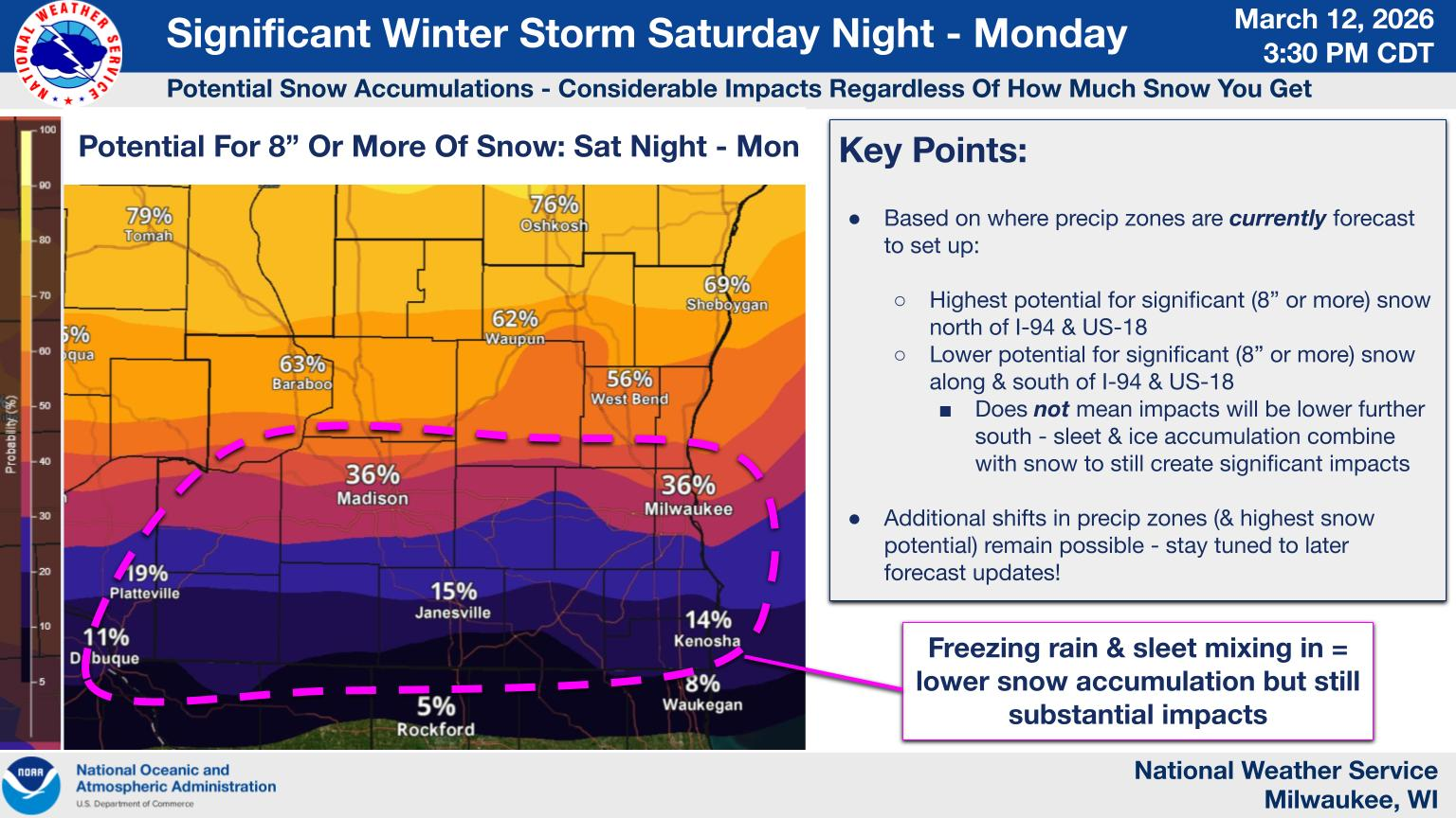
Significant Winter Storm To Hit WI, 8+ Inches Of Snow Possible
A winter storm watch is in effect for portions of east central, south central and southeast Wisconsin.

A significant winter storm will target parts of Wisconsin this weekend and could bring heavy snow, freezing rain and strong winds to the Milwaukee area, according to the latest forecasts.
A blast of arctic air is expected to fuel the storm, which is predicted to impact the state Saturday night into Monday morning.
"After brief tastes of spring warmth across the Midwest early March, Mother Nature will send a reminder that winter is not done yet, as this powerful storm will bring the potential for some of the heaviest snow of the season across the region," AccuWeather meteorologist Brandon Buckingham said Thursday.
Find out what's happening in Milwaukeefor free with the latest updates from Patch.
A winter storm watch is in effect for the Milwaukee metro from Saturday evening through Monday afternoon.
Find out what's happening in Milwaukeefor free with the latest updates from Patch.
According to the National Weather Service, heavy snow and blowing snow are possible Saturday night and Sunday, especially north of Interstate 94.
A wintry mix is also possible for a time Saturday night and Sunday, including a chance for sleet and freezing rain, particularly along and south of the I-94 corridor. Rain may also mix in for a time, mainly south of I-94.
The wintry mix is expected to transition to moderate to heavy snow across southern Wisconsin Sunday evening, persisting into Monday.
Strong winds are expected to continue into Monday, which will likely cause hazardous travel conditions across the region.
On Thursday, the National Weather Service predicted that the Milwaukee region has a 36 percent chance of receiving more than 8 inches of snow over the course of the storm.
"There remains a fair amount of uncertainty with the track of this system as well as precipitation types and amounts," the National Weather Service-Milwaukee office said. "Monitor the latest forecasts for updates on this situation."
Here's a look at the detailed National Weather Service forecast for the Milwaukee area:
Thursday Night: Rain, mainly before 4am, then a chance of showers after 4am. Low around 35. Windy, with a south wind 10 to 15 mph increasing to 20 to 25 mph after midnight. Winds could gust as high as 45 mph. Chance of precipitation is 90%. New precipitation amounts between a tenth and quarter of an inch possible.
Friday: A slight chance of rain and snow showers before 9am, then a slight chance of snow showers between 9am and 10am. Partly sunny, with a high near 43. Windy, with a west wind 25 to 30 mph, with gusts as high as 55 mph. Chance of precipitation is 20%.
Friday Night: Mostly cloudy, with a low around 28. Northwest wind 10 to 15 mph decreasing to 5 to 10 mph after midnight. Winds could gust as high as 30 mph.
Saturday: A 20 percent chance of snow after 1pm. Cloudy, with a high near 37. North wind 5 to 10 mph becoming southeast in the afternoon.
Saturday Night: Snow before 4am, then snow, possibly mixed with rain. Low around 32. East wind 10 to 15 mph, with gusts as high as 25 mph. Chance of precipitation is 100%. New snow accumulation of 1 to 3 inches possible.
Sunday: Rain and snow before 1pm, then rain and snow, possibly mixed with sleet. High near 38. Windy, with an east wind 20 to 25 mph, with gusts as high as 40 mph. Chance of precipitation is 100%. New snow and sleet accumulation of less than one inch possible.
Sunday Night: Snow, possibly mixed with rain, becoming all snow after 1am. The snow could be heavy at times. Widespread blowing snow after 10pm. Low around 18. Windy, with a north wind 20 to 25 mph, with gusts as high as 40 mph. Chance of precipitation is 100%. New precipitation amounts between a half and three quarters of an inch possible.
Monday: Snow likely, mainly before 1pm. Areas of blowing snow before 1pm. Mostly cloudy, with a high near 24. Windy, with a northwest wind around 25 mph, with gusts as high as 45 mph. Chance of precipitation is 60%.
Get more local news delivered straight to your inbox. Sign up for free Patch newsletters and alerts.