Weather
'High Risk For Tornadoes' Tuesday, NWS Warns: WI Weather
"Have a way to receive warnings," the National Weather Service warned Wisconsin residents ahead of Tuesday's storms.


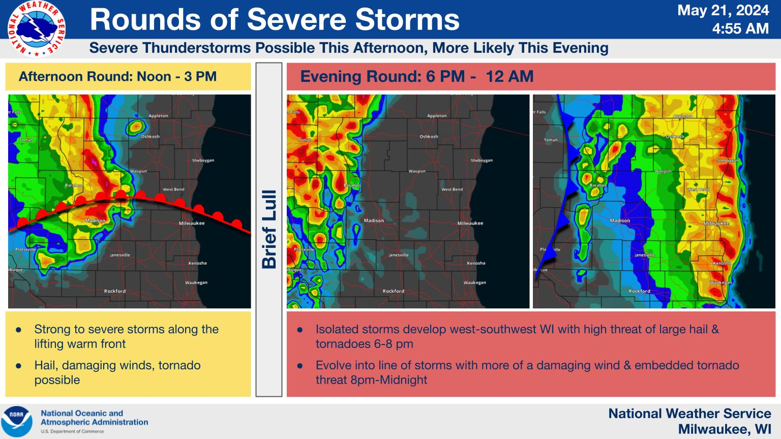
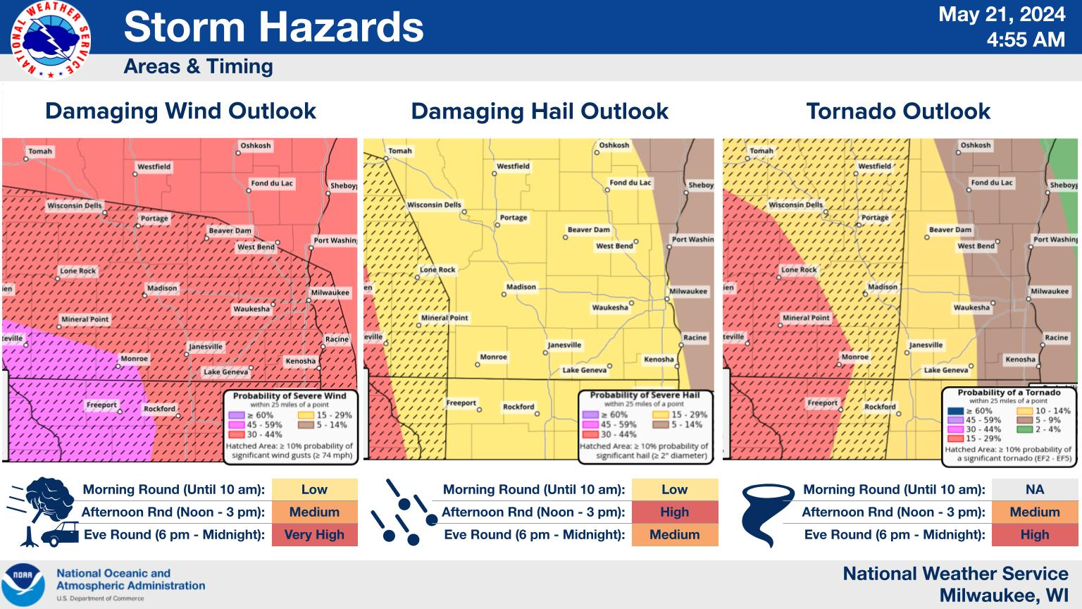
MILWAUKEE — Wisconsinites should be prepared for multiple rounds of significant storms Tuesday, including a "high risk for tornadoes" this evening, the National Weather Service said.
The morning round of storms may contain small hail and gusty winds.
The afternoon round has a high risk of large hail, a medium risk of damaging winds, and a small risk of tornadoes.
Find out what's happening in Milwaukeefor free with the latest updates from Patch.
The evening round has a "very high risk for damaging winds, a high risk for tornadoes, and a medium risk for large hail," the NWS said. "Have a way to receive warnings."
Here's the specific NWS forecast from the Milwaukee Airport:
Find out what's happening in Milwaukeefor free with the latest updates from Patch.
Tuesday: Areas of dense fog before 10am. Otherwise, mostly cloudy, with a high near 68. Light east wind becoming southeast 5 to 10 mph in the morning.
Tuesday Night: Showers and thunderstorms, mainly before 1am. Low around 57. Breezy, with a southeast wind 15 to 20 mph becoming southwest after midnight. Winds could gust as high as 30 mph. Chance of precipitation is 80%. New rainfall amounts between a quarter and half of an inch possible.
Wednesday: Sunny, with a high near 72. West wind around 15 mph, with gusts as high as 25 mph.
Wednesday Night: Mostly clear, with a low around 55. West wind 5 to 10 mph.
Thursday: Sunny, with a high near 76. West wind 5 to 10 mph.
Thursday Night: Mostly clear, with a low around 54. South wind around 5 mph.
Friday: A 30 percent chance of showers and thunderstorms, mainly after 1pm. Mostly sunny, with a high near 71. East wind 5 to 10 mph.
Friday Night: A 50 percent chance of showers and thunderstorms. Mostly cloudy, with a low around 56. East wind 5 to 10 mph becoming south after midnight.
Saturday: A chance of showers and thunderstorms. Partly sunny, with a high near 72. Chance of precipitation is 30%.
Saturday Night: A 40 percent chance of showers. Mostly cloudy, with a low around 52.
Sunday: A 40 percent chance of showers. Partly sunny, with a high near 67.
Sunday Night: A 30 percent chance of showers. Mostly cloudy, with a low around 53.
Memorial Day: A 30 percent chance of showers and thunderstorms. Mostly sunny, with a high near 69.
Get more local news delivered straight to your inbox. Sign up for free Patch newsletters and alerts.