Weather
Ice Then Storms: Wisconsin Faces Slick Commute, Severe Risk
Freezing rain north of I-94 could create icy roads Thursday morning before damaging winds, hail and possible tornadoes later in the day.


MILWAUKEE, WI — A messy and potentially dangerous spring weather system is set to move through Wisconsin from Wednesday night into Thursday evening, bringing everything from freezing rain to strong thunderstorms.
Forecasters say freezing rain and sleet are possible late Wednesday night into early Thursday, mainly north of the I-94 corridor. Ice accumulation is expected to be light overall, but a glaze of up to a tenth of an inch is possible, with isolated higher amounts.
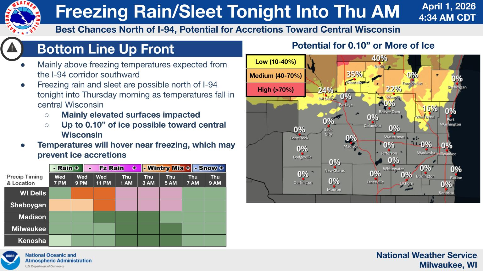
The biggest concern during the morning hours will be slick roads, especially on bridges and overpasses. While most surfaces may remain just above freezing, some icy spots could develop in areas farther north, potentially impacting the Thursday morning commute.
Find out what's happening in Milwaukeefor free with the latest updates from Patch.
South of I-94, including Milwaukee, the system is expected to fall mainly as rain.
Temperatures are expected to rise quickly Thursday morning, changing any lingering wintry mix over to all rain. But that’s not the end of the story.
Find out what's happening in Milwaukeefor free with the latest updates from Patch.
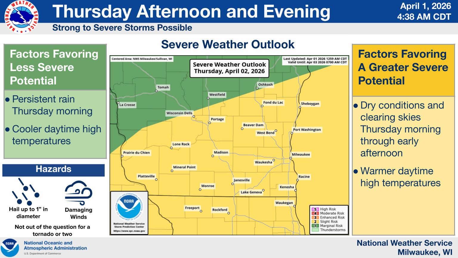
By Thursday afternoon and evening, conditions could shift toward severe weather. If enough warming and instability develop, strong to severe thunderstorms may form across the region.
The primary threats include damaging winds and large hail, though an isolated tornado cannot be ruled out. Locally heavy rainfall is also possible.
Storms are expected to move out from west to east Thursday evening, bringing an end to the system.
Forecasters note that exact impacts will depend on the track of the storm system, and residents should stay updated as conditions evolve.
Here's the full NWS forecast from the Milwaukee Airport:
Today: Mostly cloudy, with a high near 38. Breezy, with a northeast wind 15 to 20 mph, with gusts as high as 30 mph.
Tonight: Showers, mainly after 9pm. Low around 34. Breezy, with an east wind 15 to 20 mph, with gusts as high as 30 mph. Chance of precipitation is 80%. New precipitation amounts between a quarter and half of an inch possible.
Thursday: Showers and possibly a thunderstorm. High near 62. East wind around 15 mph becoming south in the afternoon. Winds could gust as high as 30 mph. Chance of precipitation is 100%. New rainfall amounts between a half and three quarters of an inch possible.
Thursday Night: Showers and possibly a thunderstorm before 1am. Low around 42. West wind 10 to 15 mph, with gusts as high as 25 mph. Chance of precipitation is 80%. New rainfall amounts between a tenth and quarter of an inch, except higher amounts possible in thunderstorms.
Friday: Mostly sunny, with a high near 56. West wind around 5 mph becoming east in the afternoon.
Friday Night: Showers and possibly a thunderstorm. Low around 40. Northeast wind 5 to 10 mph. Chance of precipitation is 90%. New rainfall amounts between a quarter and half of an inch possible.
Saturday: Showers likely, mainly before 1pm. Mostly cloudy, with a high near 58. South wind 10 to 15 mph becoming west in the afternoon. Chance of precipitation is 60%. New precipitation amounts between a tenth and quarter of an inch possible.
Saturday Night: A 20 percent chance of showers before 1am. Mostly cloudy, with a low around 32. West wind around 15 mph.
Sunday: Mostly cloudy, with a high near 47.
Sunday Night: Partly cloudy, with a low around 31.
Monday: A chance of rain and snow showers. Partly sunny, with a high near 49. Chance of precipitation is 40%.
Monday Night: A chance of rain and snow showers. Mostly cloudy, with a low around 30. Chance of precipitation is 40%.
Tuesday: A 30 percent chance of snow showers. Mostly cloudy, with a high near 42.
Get more local news delivered straight to your inbox. Sign up for free Patch newsletters and alerts.