Weather
Multiple Waves Of Winter Weather Expected As Major Storm Targets WI
A long-duration winter storm could bring rain, thunderstorms, freezing rain and accumulating snow to the Milwaukee region this weekend.

A major storm system is expected to target Wisconsin this weekend, creating a prolonged weather event that will likely bring multiple rounds of wintry precipitation and accumulating snowfall to the Milwaukee area and southern parts of the state.
A winter storm watch remains in effect from 7 p.m. Saturday until 4 p.m. for much of southern Wisconsin, including the cities of Milwaukee, Waukesha, Burlington, Racine and Kenosha, according to the National Weather Service.
“This is shaping up to be one of the most expansive and impactful storms that the United States has experienced so far this year,” AccuWeather Senior Meteorologist John Feerick said Friday. “Millions of people could be impacted by travel delays, power outages, business shutdowns and school closures, even after the storm exits.”
Find out what's happening in Milwaukeefor free with the latest updates from Patch.
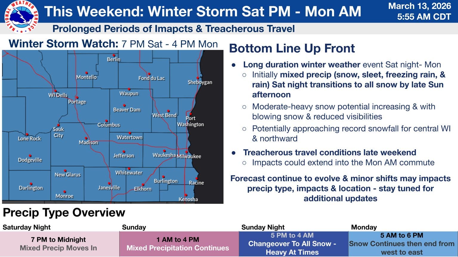
The storm is expected to strengthen as it moves from the Rockies into the Plains and Great Lakes from Saturday through Monday, interacting with an advancing surge of Arctic air, AccuWeather said in its latest forecast.
According to the National Weather Service, the storm is expected to impact southern Wisconsin during the last half of the weekend in three phases.
Find out what's happening in Milwaukeefor free with the latest updates from Patch.
The first phase will run from Saturday night into Sunday morning and will feature a Winter Weather Advisory. During this time, snow accumulations of 1 to 3 inches are expected in the advisory area, along with up to a tenth of an inch of ice accumulation.
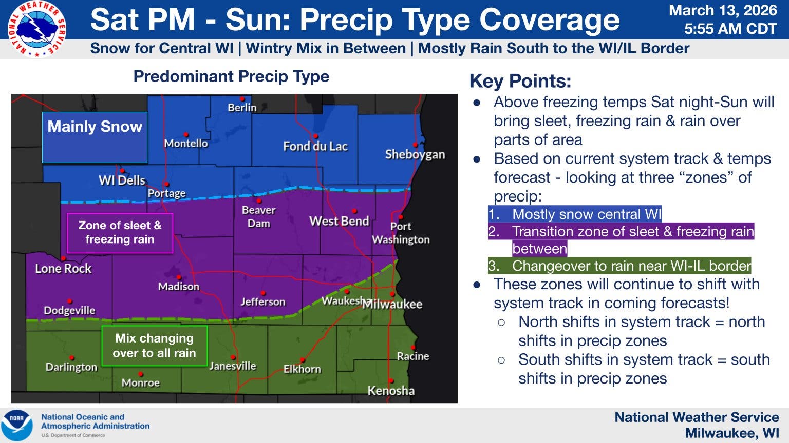
The second phase is then expected to start Sunday late morning into Sunday afternoon as warm air causes a transition to rain over a majority of southern Wisconsin. Thunderstorms may occur during this time, forecasters said.
The last phase will then run from late Sunday afternoon through Monday as cold air moves back into the area and heavy snow moves in.
Snowfall totals from 5 to 9 inches are possible during the final phase, according to the National Weather Service. A light glaze of ice may also occur, especially over central and east-central Wisconsin.
Forecasters said there is a 54 percent chance the Milwaukee metro could see more than 6 inches of snow, and a 38 percent chance that more than 12 inches could fall.
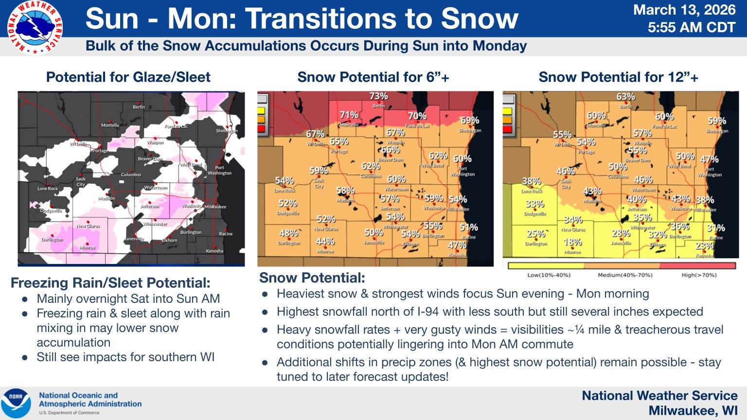
Additionally, wind gusts up to 45 mph will cause blowing snow
and visibility restrictions, forecasters said. Hazardous travel conditions are expected during the duration of the storm.
"This forecast continues to evolve and minor shifts may impact precipitation types, impact and location," the National Weather Service's Milwaukee office wrote. "Stay tuned for additional updates."
Here's a look at the detailed National Weather Service forecast for the Milwaukee metro:
Friday Night: Partly cloudy, with a low around 28. Blustery, with a northwest wind 15 to 20 mph decreasing to 5 to 10 mph after midnight. Winds could gust as high as 40 mph.
Saturday: A 20 percent chance of snow after 4pm. Cloudy, with a high near 37. Light and variable wind becoming southeast 5 to 10 mph in the afternoon.
Saturday Night: Rain and snow likely before 1am, then rain and sleet likely between 1am and 4am, then rain likely after 4am. Cloudy, with a low around 32. East wind 10 to 15 mph, with gusts as high as 30 mph. Chance of precipitation is 70%. New snow and sleet accumulation of around an inch possible.
Sunday: Rain likely before 1pm, then rain and possibly a thunderstorm between 1pm and 4pm, then rain after 4pm. High near 52. Southeast wind around 15 mph, with gusts as high as 35 mph. Chance of precipitation is 90%. New rainfall amounts between a half and three quarters of an inch possible.
Sunday Night: Rain before 10pm, then snow, possibly mixed with rain between 10pm and 1am, then snow after 1am. Patchy blowing snow after 2am. Low around 20. Blustery, with a north wind around 20 mph, with gusts as high as 45 mph. Chance of precipitation is 90%. New snow accumulation of 1 to 3 inches possible.
Monday: Snow, mainly before 1pm. Patchy blowing snow. High near 27. Windy, with a northwest wind 20 to 25 mph, with gusts as high as 45 mph. Chance of precipitation is 80%.
Monday Night: A 30 percent chance of snow before 1am. Cloudy, then gradually becoming partly cloudy, with a low around 9. Blustery, with a northwest wind 15 to 20 mph, with gusts as high as 35 mph.
Tuesday: Mostly sunny, with a high near 24.
Get more local news delivered straight to your inbox. Sign up for free Patch newsletters and alerts.