Weather
NWS: 'Very Large Hail,' Tornadoes Possible In Milwaukee Area Today
Forecasters warn of tornadoes, damaging winds and very large hail as storms develop this afternoon and evening.

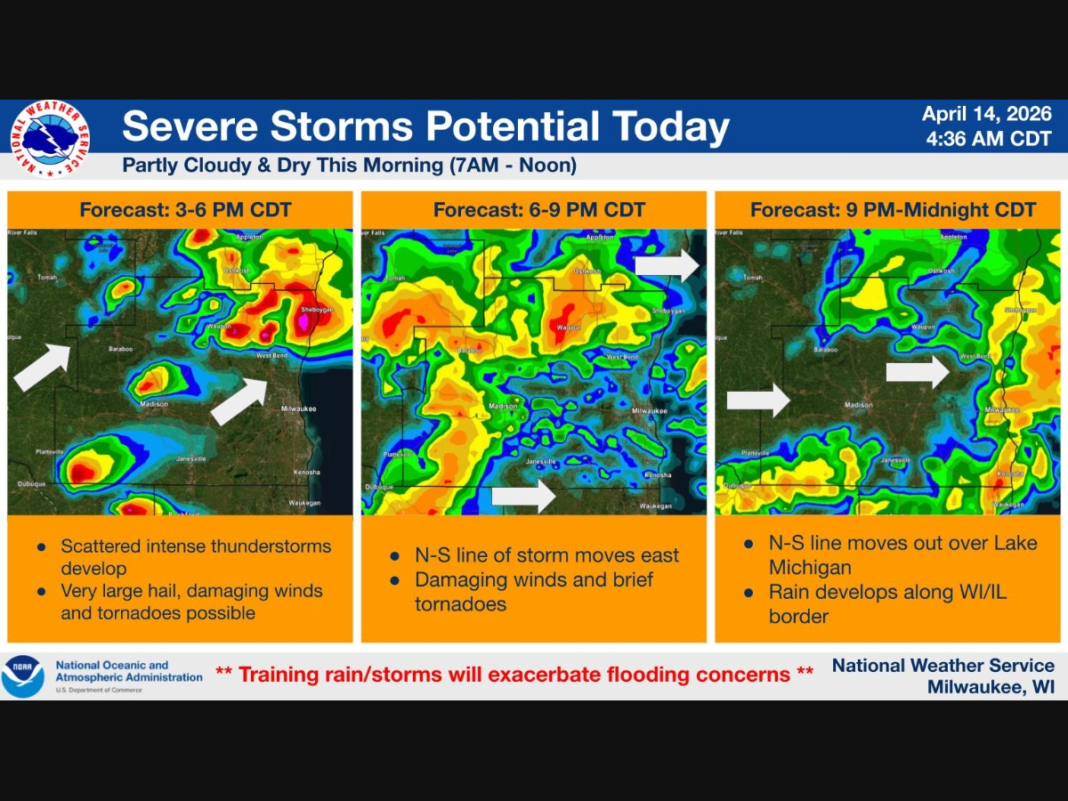


MILWAUKEE, WI — Forecasters are warning that dangerous storms capable of producing tornadoes and very large hail could move into the Milwaukee area later today.
The National Weather Service says “very large hail greater than golf ball size” and a few tornadoes are possible as storms develop this afternoon and intensify into the evening.
All severe weather hazards are on the table, including damaging winds, large hail and tornadoes.
Find out what's happening in Milwaukeefor free with the latest updates from Patch.
Storms are expected to begin developing by mid-afternoon, with the greatest threat during the evening hours as activity increases in coverage and intensity across southeast Wisconsin.
Forecasters say storms will likely begin as isolated cells before organizing into clusters or a line as they move east toward Lake Michigan.
Find out what's happening in Milwaukeefor free with the latest updates from Patch.
Early, discrete storms may carry the highest risk for tornadoes and very large hail. As storms merge, damaging winds and brief spin-up tornadoes could become the primary threats.
A Flood Watch remained in effect until 7 a.m. Tuesday, and any storms later today could produce torrential rainfall that may worsen flooding concerns.
Residents are urged to have multiple ways to receive warnings and be ready to take shelter immediately if warnings are issued.
Spotter activation is expected this afternoon and evening, signaling the potential for significant severe weather.
Additional severe storms are possible again Wednesday, though the timing and location remain uncertain. Another round of storms could also arrive late this week.
Here's the full NWS forecast from the Milwaukee Airport:
Today
A 30 percent chance of showers and thunderstorms, mainly after 4pm. Patchy dense fog. Otherwise, mostly cloudy, with a high near 64. Southwest wind around 10 mph becoming south in the afternoon.
Tonight
Showers and thunderstorms before 9pm, then showers and possibly a thunderstorm, mainly after 9pm. Widespread dense fog, mainly after 3am. Low around 49. East wind 5 to 10 mph becoming west in the evening. Chance of precipitation is 80%. New rainfall amounts between three quarters and one inch possible.
Wednesday
Showers and possibly a thunderstorm. Areas of dense fog before 1pm. High near 62. South wind 5 to 10 mph. Chance of precipitation is 90%. New rainfall amounts between a tenth and quarter of an inch, except higher amounts possible in thunderstorms.
Wednesday Night
Showers likely and possibly a thunderstorm. Cloudy, with a low around 49. South wind 5 to 10 mph becoming west after midnight. Chance of precipitation is 70%. New precipitation amounts between a quarter and half of an inch possible.
Thursday
A 50 percent chance of showers. Mostly cloudy, with a high near 58. West wind around 10 mph.
Thursday Night
A 20 percent chance of showers before 1am. Mostly cloudy, with a low around 45. Northeast wind around 10 mph.
Friday
Mostly cloudy, with a high near 59. Southeast wind 10 to 15 mph.
Friday Night
Showers and possibly a thunderstorm. Steady temperature around 56. Southeast wind around 15 mph. Chance of precipitation is 80%. New rainfall amounts between a quarter and half of an inch possible.
Saturday
Showers likely and possibly a thunderstorm before 1pm, then a chance of showers and thunderstorms after 1pm. Mostly cloudy, with a steady temperature around 55. Breezy. Chance of precipitation is 60%.
Saturday Night
A 20 percent chance of showers before 1am. Mostly cloudy, with a low around 35. Breezy.
Sunday
Partly sunny, with a high near 47. Breezy.
Sunday Night
Mostly clear, with a low around 35.
Monday
Sunny, with a high near 49.
Get more local news delivered straight to your inbox. Sign up for free Patch newsletters and alerts.